


Details
Collection: 917.8 Un3r v.11 map Digitized Images from Collection
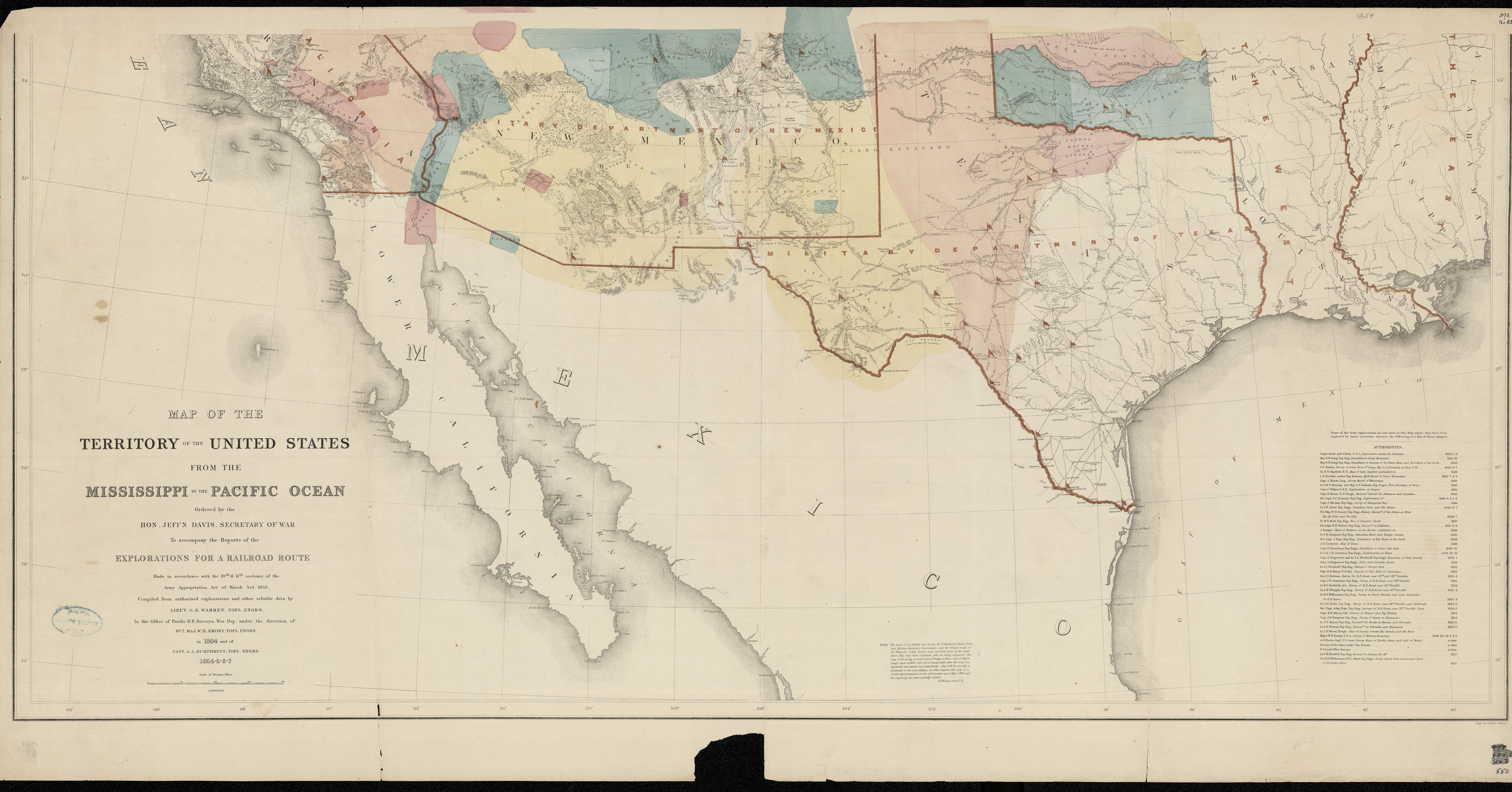
Title: Map of the territory of the United States from the Mississippi River to the Pacific Ocean : __ordered by Jeff'n Davis, Secretary of War to accompany the reports of the explorations for a railroad route : made in accordance with the 10th & 11th sections of the Army Appropriation Act of March 3rd 1853 / __compiled from authorized explorations and other reliable data by G.K. Warren in the Office of Pacific R.R. Surveys, War Dept. under the direction of W.H. Emory in 1854 and of A.A. Humphreys 1854-5-6-7 ; engr. by Selmar Siebert
Date: ca. 1857
Summary: Warren, Gouverneur Kemble,--1830-1882 -- Railroads--West (U.S.)--Maps --Pacific railroads--Explorations and surveys--Maps
Collection: 917.8 Un3r v.11 map Digitized Images from Collection
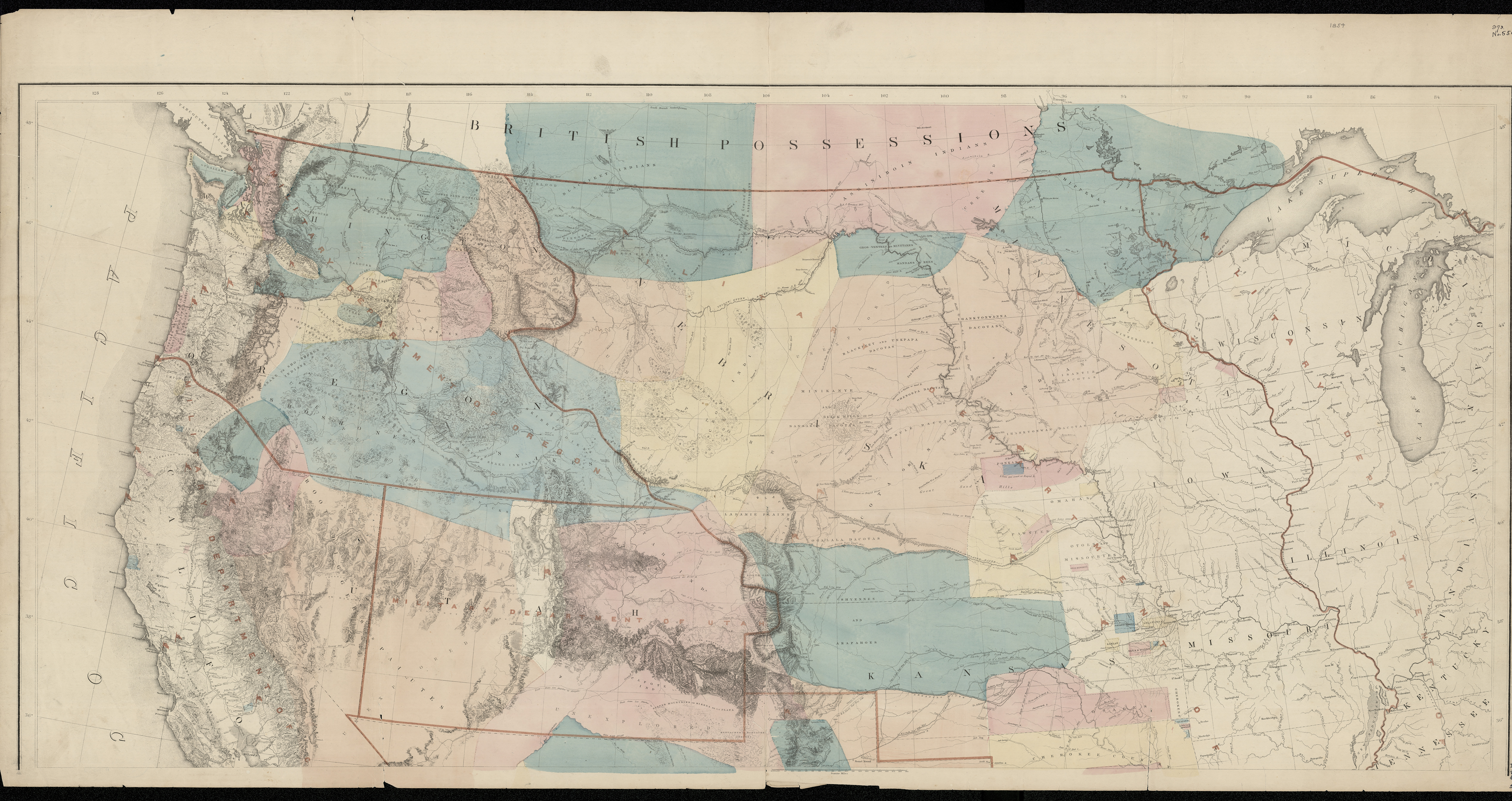
Title: Map of the territory of the United States from the Mississippi River to the Pacific Ocean : __ordered by Jeff'n Davis, Secretary of War to accompany the reports of the explorations for a railroad route : made in accordance with the 10th & 11th sections of the Army Appropriation Act of March 3rd 1853 / __compiled from authorized explorations and other reliable data by G.K. Warren in the Office of Pacific R.R. Surveys, War Dept. under the direction of W.H. Emory in 1854 and of A.A. Humphreys 1854-5-6-7 ; engr. by Selmar Siebert
Date: ca. 1857
Summary: Warren, Gouverneur Kemble,--1830-1882 -- Railroads--West (U.S.)--Maps --Pacific railroads--Explorations and surveys--Maps
Enter a subject or term in one or both of the “Search” boxes.
- “Item Detail” searches the Title, Creator and Summary fields of all item-level records.
- “Collection Number” searches the Collection Number field only and requires an exact match.
The “DETAILS” button provides additional information about an item, as well as the following options:
- “Collection Summary” details the contents of the entire collection in which the selected item is located.
- You can print the image and its corresponding details by selecting “Print".
- “Digitized Images from the Collection” returns a list of all digitized items within that collection (available from the “Collection Summary” screen).
Click on image to expand/zoom the image view.
“Photobook home” takes you back to the main Photobook page where you can start a new search.
“Featured Collections” showcases new and/or popular collections and the digitized images within those collections.
Information on how to order copies is located here.
The collections preserved in the North Dakota State Archives include over a million images. Only a small percentage of these images have been digitized. This photo gallery provides a preview of the images that have been digitized.
For more information on the non-digitized images, please refer to the finding aids found on our website at history.nd.gov, or ask a member of our reference staff for assistance.