This image may be restricted. Contact reference staff for assistance.
Collection: 2019P162 - Leo D. Harris Photo Collection
Series:
Folder:
0001
Item:
00010
Title:
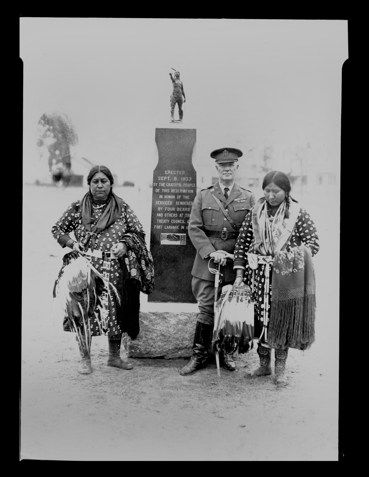
Unveiling of the monument to Four Bears for services rendered at the Fort Laramie Treaty Council of 1851, Elbowoods (N.D.)
Date:
09/08/1933
Creator:
Harris, Leo D.
Inscription/Marks:
Summary:
White Body Woman, Gros Ventre from Elbowoods, Major Alfred Burton Welch and Sarah Brown of Van Hook in regalia at unveiling of the Monument to the Treaty Council at Fort Laramie of 1851 monument honoring Four Bears and other council member's work with the Fort Laramie Treaty in Elbowoods (N.D.) The inscription on the monument reads: "Erected Sept. 6 1933 by the grateful people of this reservation in honor of services rendered by Four Bears and others at the Treaty Council at Fort Laramie in 1851. Mandan side lists Raven Chief; Gros Ventre lists: Four Bears, Chicken Bear, Man Chief, Black Shield, Advancing Along, Red Thigh, Never Retreats, H. Culbertson, Interpreter. It is surrounded by a metal fence. Currently located near the Three Affiliated Tribal Headquarters building at New Town (N.D.). __[History] In 1851, a tribal delegation of Mandan, Hidatsa, and Arikara (Sahnish) accompanied Father Pierre-Jean DeSmet to Fort Laramie to hold council with representatives of the government of the United States. White Wolf spoke for the Mandans, Four Bears for the Hidatsa, and Iron Bear for the Arikara. Colonel M. Mitchell and Major Fitzpatrick represented the government. The boundaries of the Mandan, Hidatsa, and Arikara territory were set-aside in the 1851 Fort Laramie Treaty: Commencing at the mouth of the Heart River; thence up the Missouri to the mouth of the Yellowstone River; thence up the Yellowstone to the mouth of Powder River, thence in a southeasterly direction to the headwaters of the Little Missouri River, thence along the Black Hills to the headwaters of the Heart River; thence down the Heart River to the place of the beginning. (11 Stats., p. 749, in Kappler, 1972, p. 594, Article 5) This was the largest treaty council ever held. More than ten thousand plains Indians from the Lakota, Cheyenne, Arapaho, Crow, Mandan, Arikara, Assiniboine, and Gros Ventres (Hidatsa) nations attended. In exchange for $50,000 a year for 50 years, the nations agreed to allow the United States to construct roads and military posts through their country. The tribes also established the boundaries of their territories and agreed to maintain peaceful relations with one another and with the United States. Several tribes, including the Mandans, Gros Ventres (Hidatsas), Crows, Blackfeet, and some bands of the Cheyennes and Araphaos, accepted reservations. (O’Brian, 1989, p. 141) Under the terms of agreement, the United States would supply the several tribes with $50,000 for 50 years, designate territorial boundaries of each tribe, provide punishment for depredations, and gave authority for the government to lay roads and build military forts in Indian country and other provisions. (Kappler, (compiled and edited) 1904 Indian Affairs, Laws and Treaties, Washington, Vol. II, pp. 594-596) When the treaty was returned to Washington, the U.S. Senate refused to give its approval to the long term financial arrangements, and amended the treaty by limiting the appropriation to ten years. The Indians were not a part of this amendment and believed the original treaty was still in force. In this form, the Fort Laramie Treaty of 1851 was ratified by the U.S. Senate on May 24, 1852, and the amendment was not sent to the tribes until 1853. While the government secured some signatories to the amendment, in some cases under threat to withhold annuities, the amended document was never approved by all of the tribes concerned. This amendment has been a source of controversy ever since. Following the Fort Laramie Treaty of 1851, the government established several forts along the Missouri River. In 1864 the cavalry was sent to Fort Berthold and remained there until 1867 when they moved to Fort Stevenson, 18 miles downriver. The establishment of forts brought numerous groups up river by steamboat—twenty to thirty steamboats stopped at Like-A-Fishhook Village every summer. By the early 1870s, the railroad had reached the territory of the Mandan, Hidatsa, and Arikara, a bustling economic center for the region. By 1871, federal Indian policy shifted radically for several reasons. An act of Congress in 1871 “Provided that no treaties shall hereafter be negotiated with any Indian tribe within the United States as an independent nation or people.” Thereafter, all Indian land cessions were achieved by act of Congress or by Executive Order. Indian societies were being transformed radically from a combination of forces—U. S. Army troops stationed at posts near Fort Berthold after 1864, Indian agency personnel resided on the reservation after 1868, and day schools were being opened on reservations as early as 1870.
Red ID: PH_I_149354 Image ID: 175608 Image Notes: 2019-P-162-00010