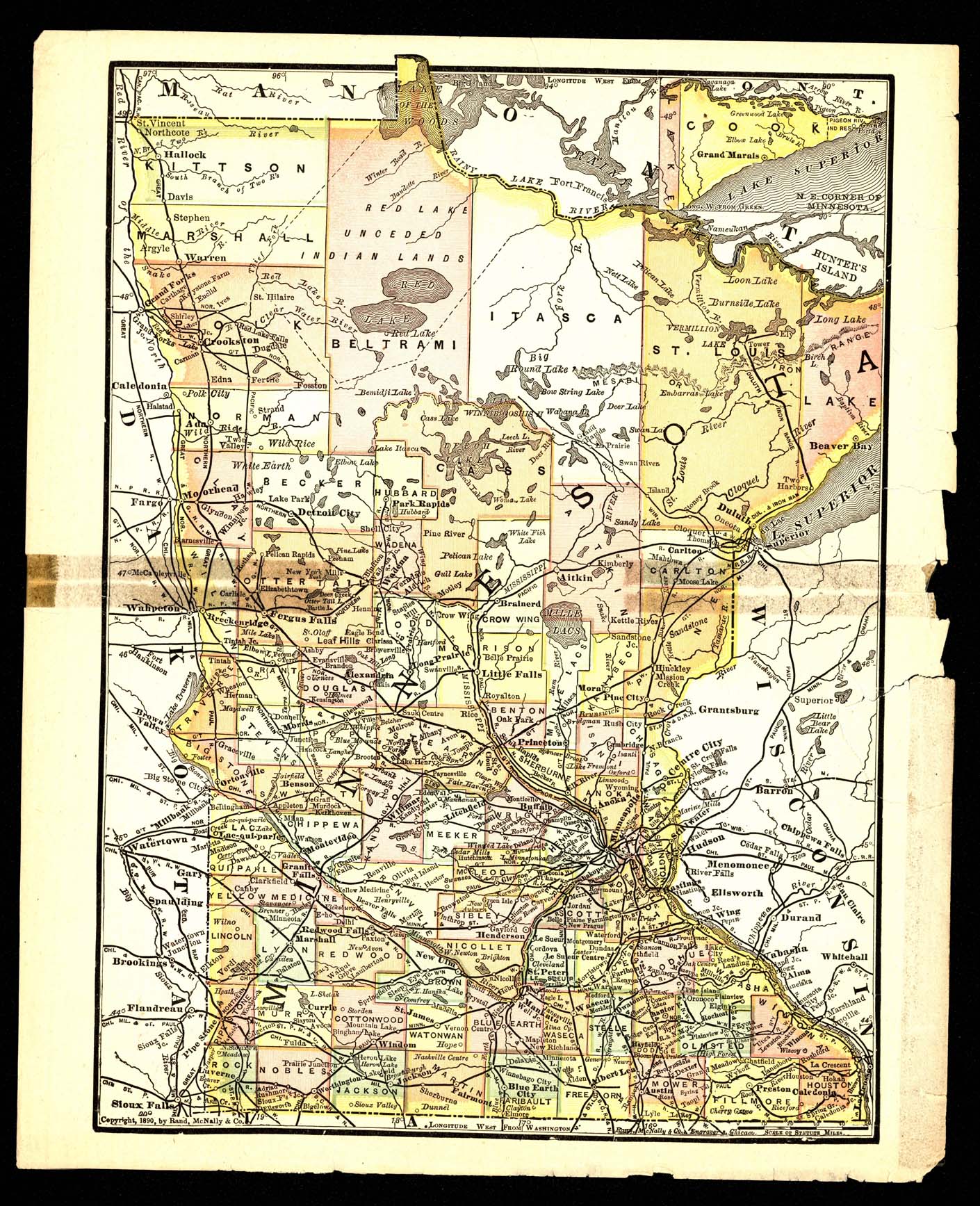
Collection: 977.6 R186m 1890 - [Map of Minnesota] / __ __Rand, McNally & Co., Engravers
Folder: Library
Item: 977.6 R186m 1890
Date: ©1890.
Creator: Rand McNally and Company
Title: [Map of Minnesota] / __ __Rand, McNally & Co., Engravers
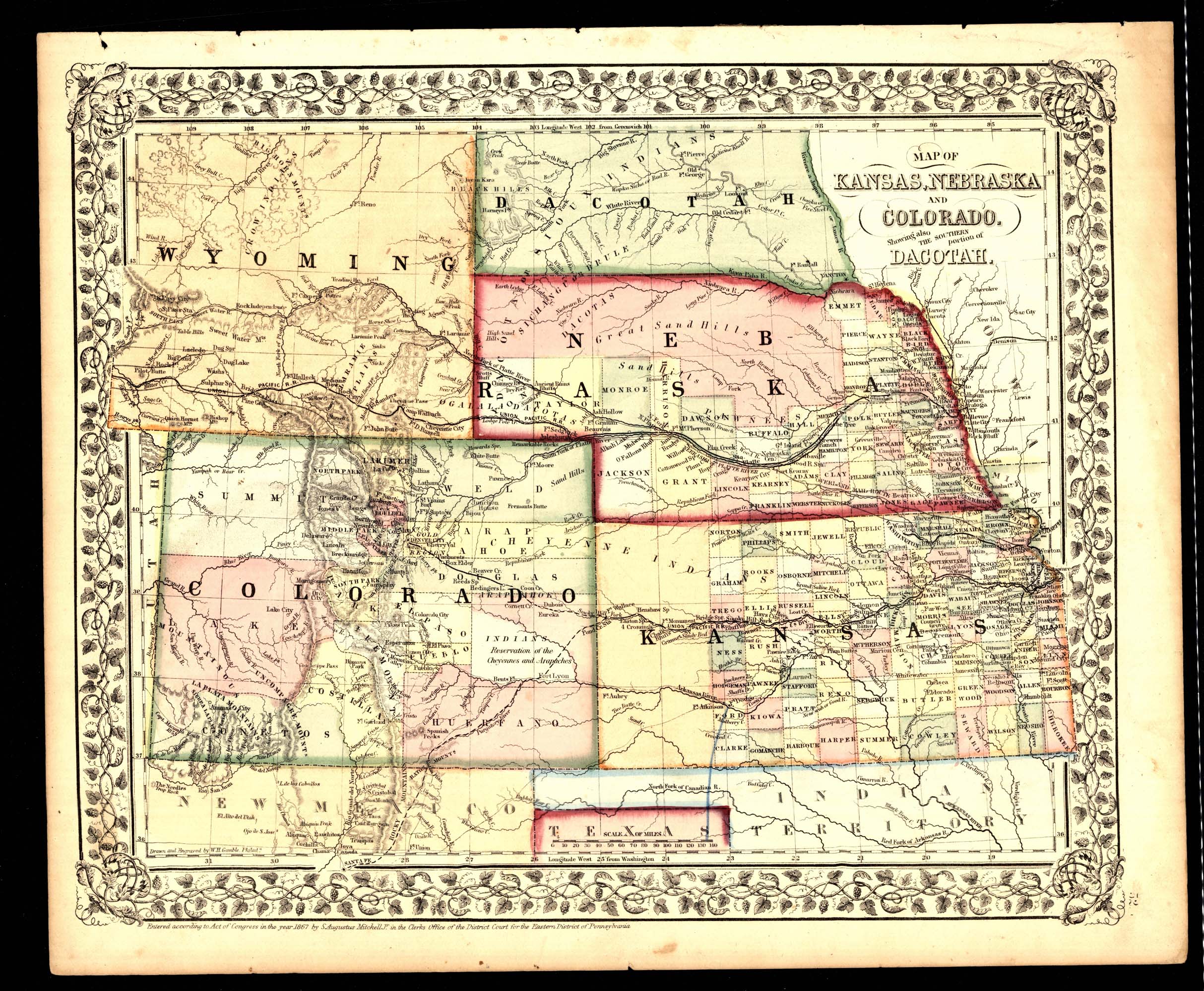
Collection: 978 G191m 1867 - Map of Kansas, Nebraska and Colorado : __showing also the southern portion of Dacotah / __drawn and engraved by W.H. Gamble
Folder: Library
Item: 978 G191m 1867
Date: ©1867.
Creator: Gamble, W. H.--(William H.)
Title: Map of Kansas, Nebraska and Colorado : __showing also the southern portion of Dacotah / __drawn and engraved by W.H. Gamble
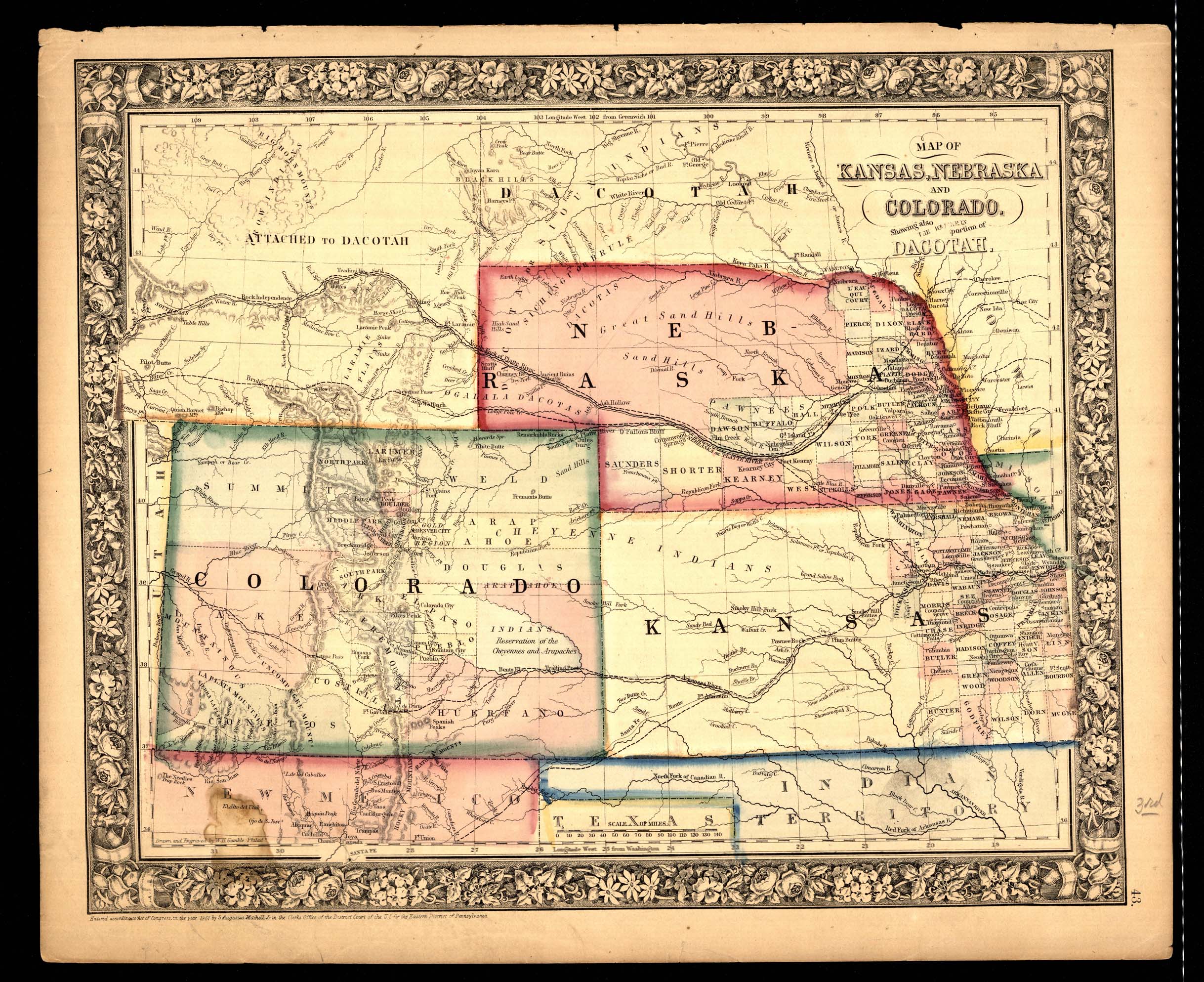
Collection: 978 G191m 1861 - Map of Kansas, Nebraska and Colorado : __showing also the southern portion of Dacotah / __drawn and engraved by W.H. Gamble
Folder: Library
Item: 978 G191m 1861
Date: ©1861.
Creator: Gamble, W. H.--(William H.)
Title: Map of Kansas, Nebraska and Colorado : __showing also the southern portion of Dacotah / __drawn and engraved by W.H. Gamble
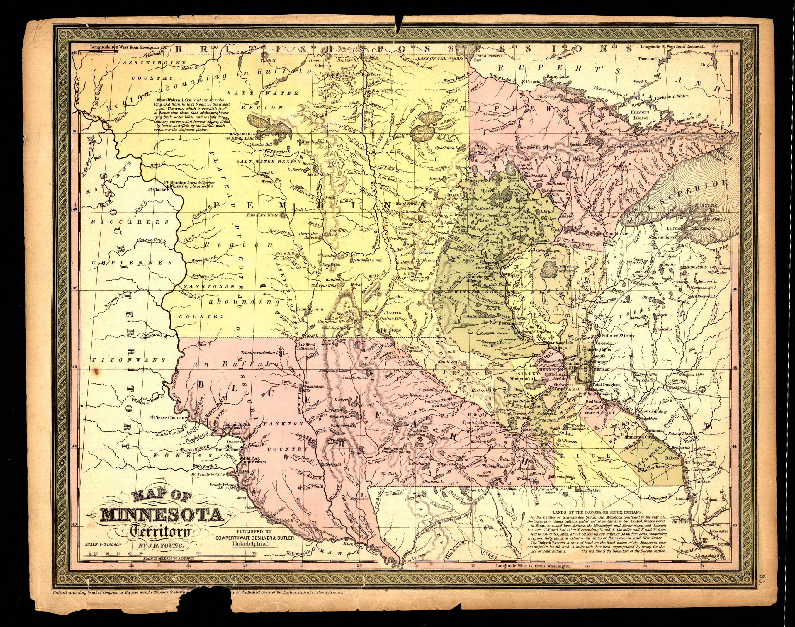
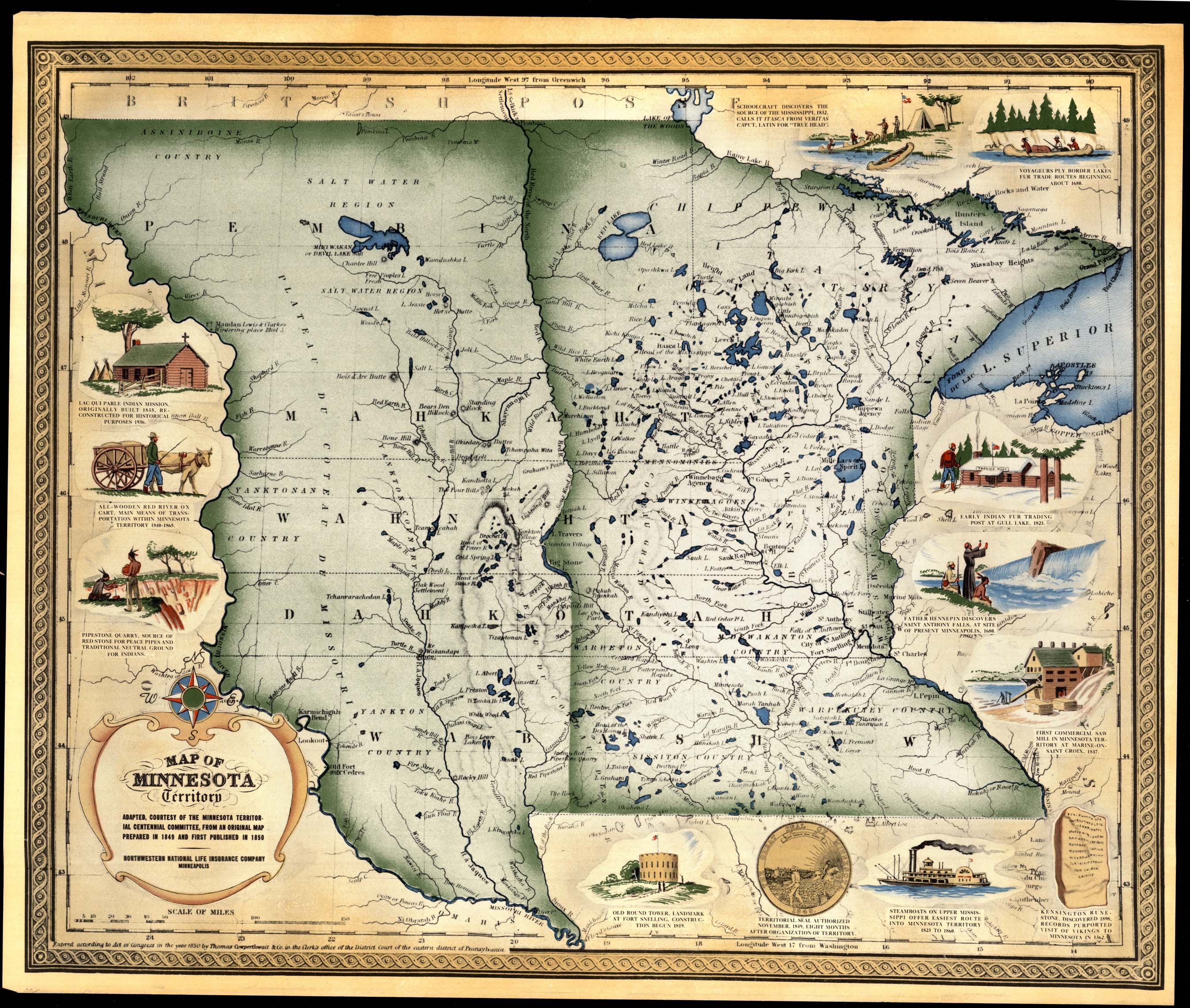
Collection: 977.604 Y68m 1850 - Map of Minnesota Territory / __ __by J.H. Young
Folder: Library
Item: 977.604 Y68m 1850
Date: ©1850.
Creator: Young, J. H.--(James Hamilton)
Title: Map of Minnesota Territory / __ __by J.H. Young
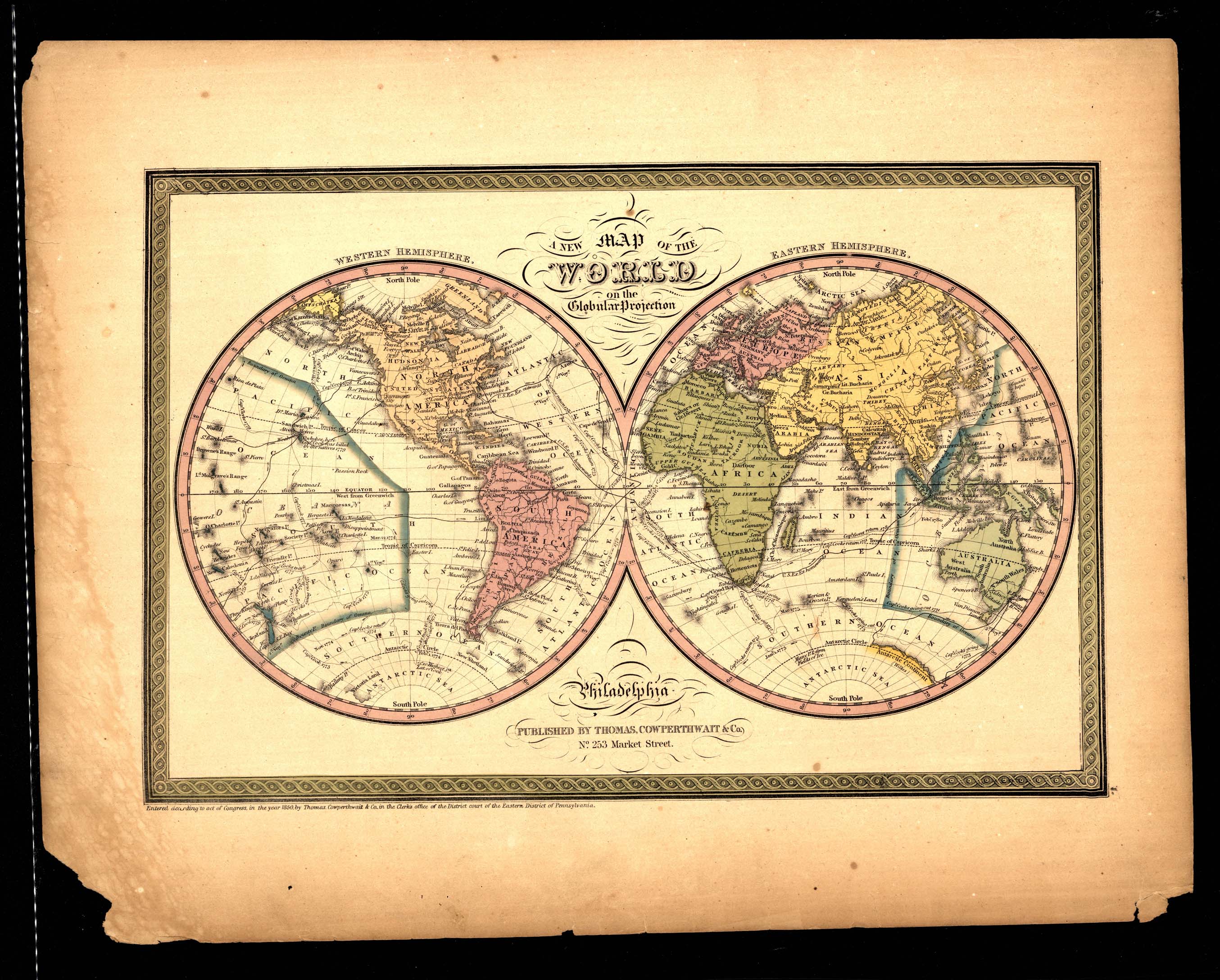
Collection: 912 T454n 1850 - A new map of the world on the globular projection
Folder: Library
Item: 912 T454n 1850
Date: ©1850.
Creator: Thomas, Cowperthwait & Co
Title: A new map of the world on the globular projection
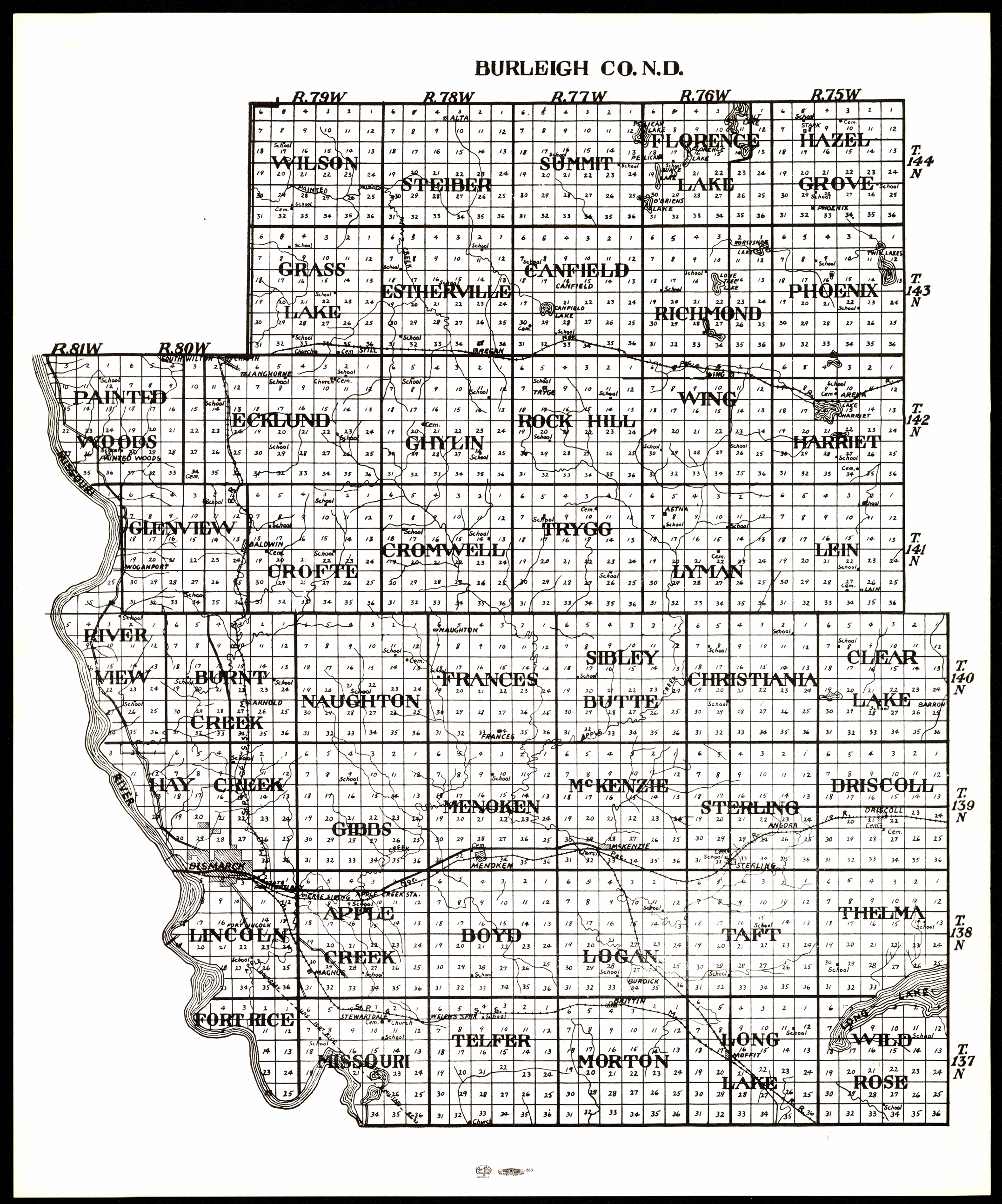
Collection: 978.477 B924 - Burleigh Co. N.D
Folder: Library
Item: 978.477 B924
Date: [between 1950 and 1980?]
Title: Burleigh Co. N.D
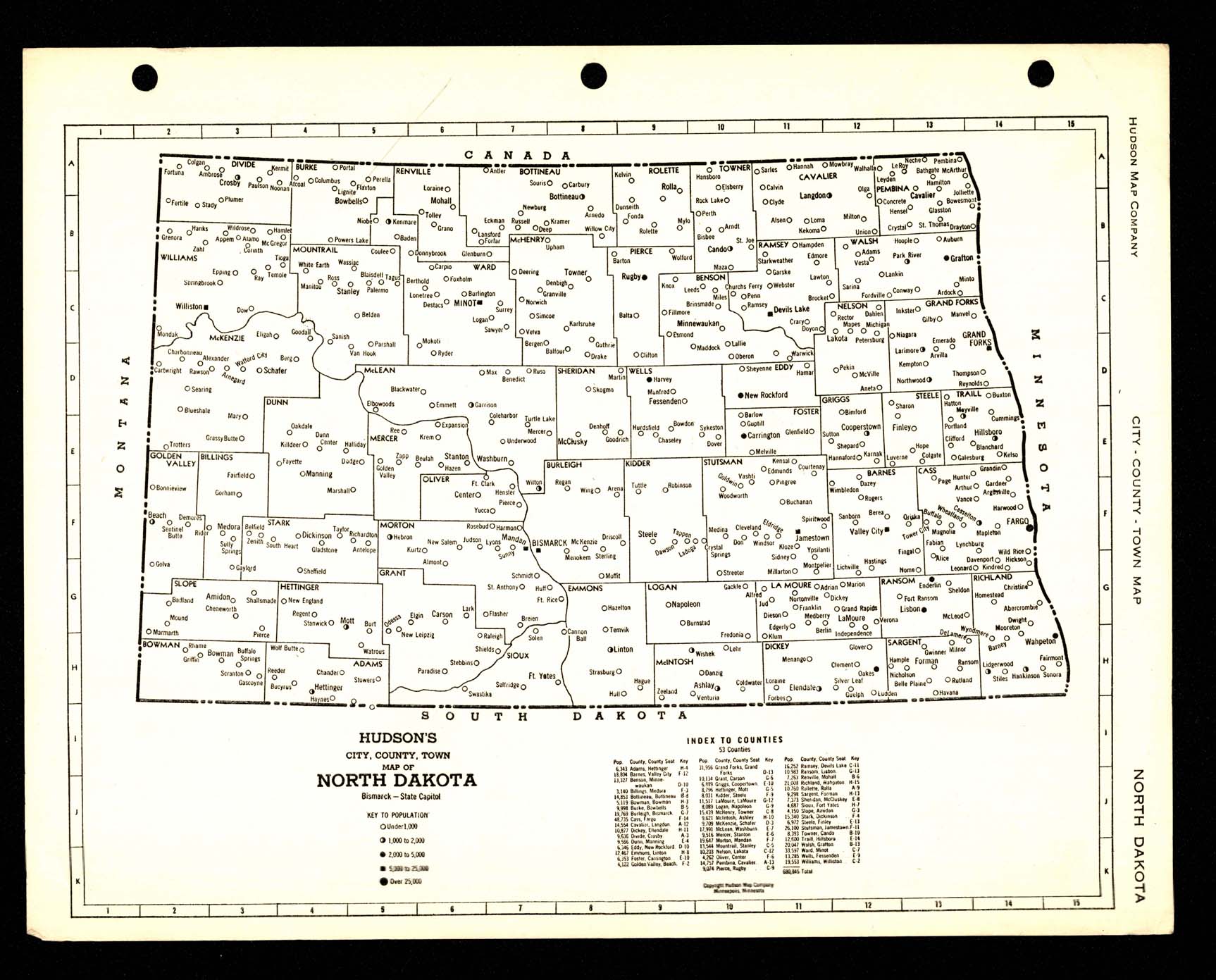
Collection: 978.4 H885h - Hudson's city, county, town map of North Dakota
Folder: Library
Item: 978.4 H885h
Date: [between 1940 and 1950?]
Creator: Hudson Map Company
Title: Hudson's city, county, town map of North Dakota
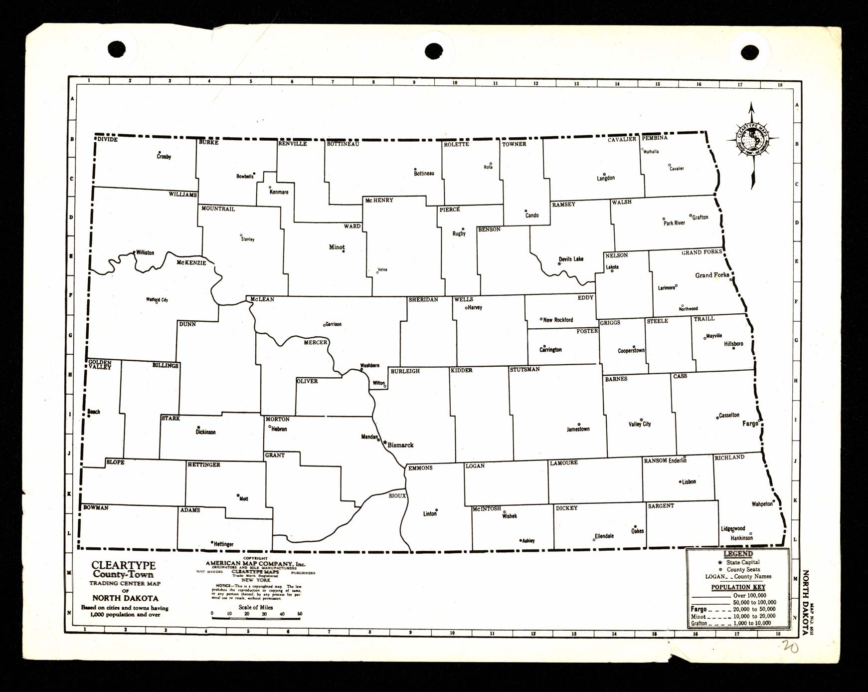
Collection: 978.4 A512c - Cleartype county-town trading center map of North Dakota
Folder: Library
Item: 978.4 A512c
Date: [between 1930 and 1940?]
Creator: American Map Company (New York, N.Y.)
Title: Cleartype county-town trading center map of North Dakota
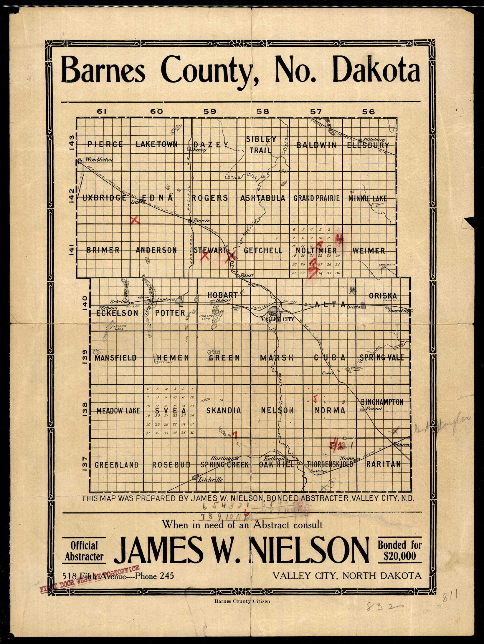
Collection: 978.432 N669 - Barnes County, No. Dakota / __ __prepared by James W. Nielson, bonded abstracter, Valley City, N.D
Folder: Library
Item: 978.432 N669
Date: [between 1900 and 1919?]
Creator: Nielson, James W.,--cartographer
Title: Barnes County, No. Dakota / __ __prepared by James W. Nielson, bonded abstracter, Valley City, N.D
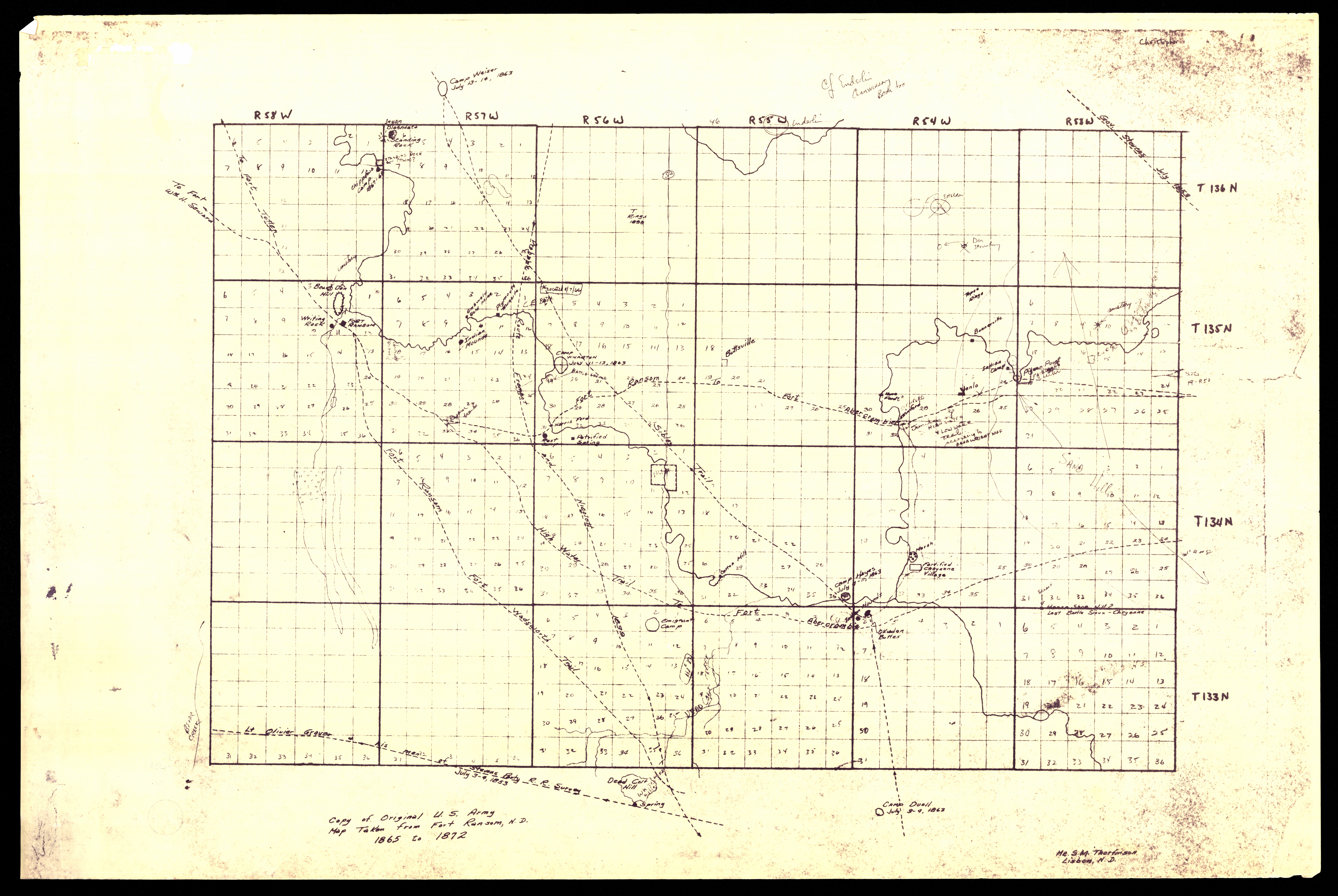
Collection: 978.4315 F736t - Copy of original U.S. Army map taken from Fort Ransom, N.D., 1865 to 1872 / __ __S.M. Thorfinson
Folder: Library
Item: 978.4315 F736t
Date: [between 1872 and 1965]
Creator: Thorfinson, S. M
Title: Copy of original U.S. Army map taken from Fort Ransom, N.D., 1865 to 1872 / __ __S.M. Thorfinson
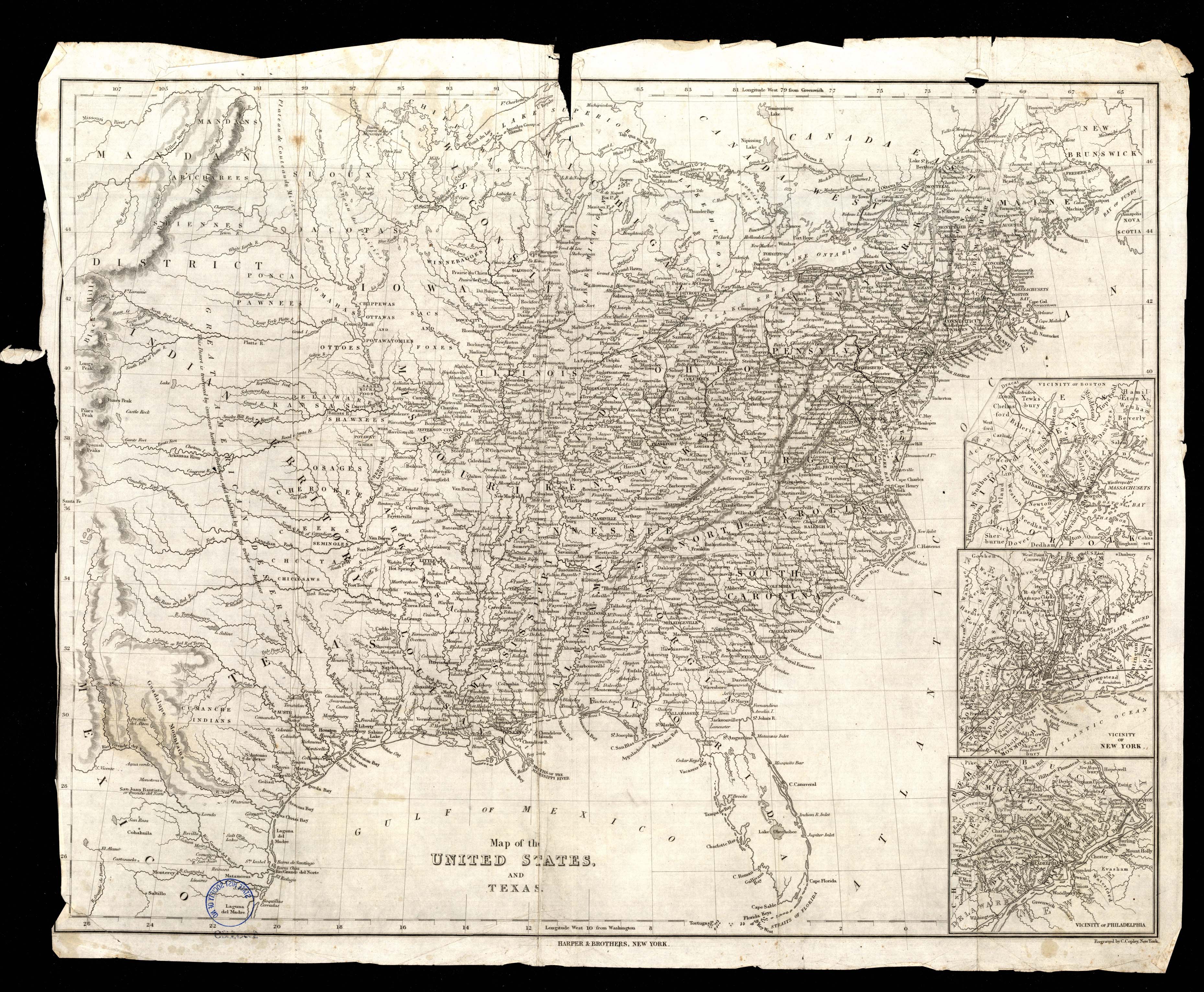
Collection: 973 M297u - Map of the United States and Texas
Folder: Library
Item: 973 M297u
Date: [between 1840 and 1850?]
Title: Map of the United States and Texas
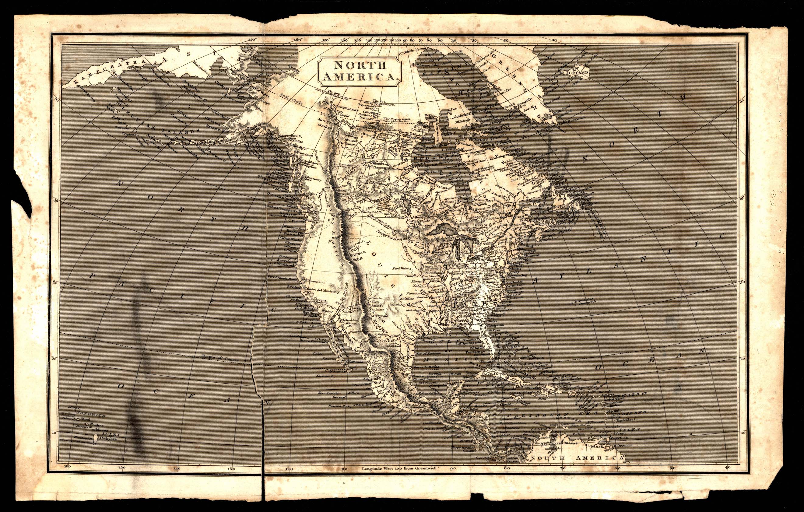
Collection: 970 N277 - North America
Folder: Library
Item: 970 N277
Date: [between 1804 and 1812?]
Title: North America
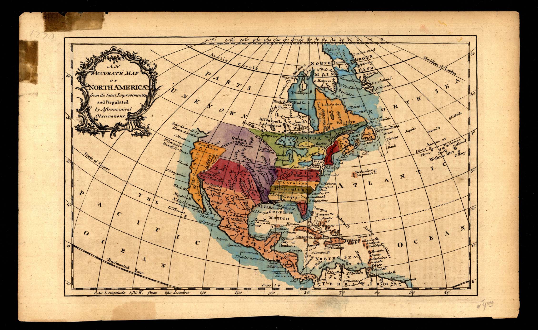
Collection: 970 R755a - An accurate map of North America from the latest improvements, and regulated by astronomical observations
Folder: Library
Item: 970 R755a
Date: [between 1760 and 1780?]
Title: An accurate map of North America from the latest improvements, and regulated by astronomical observations
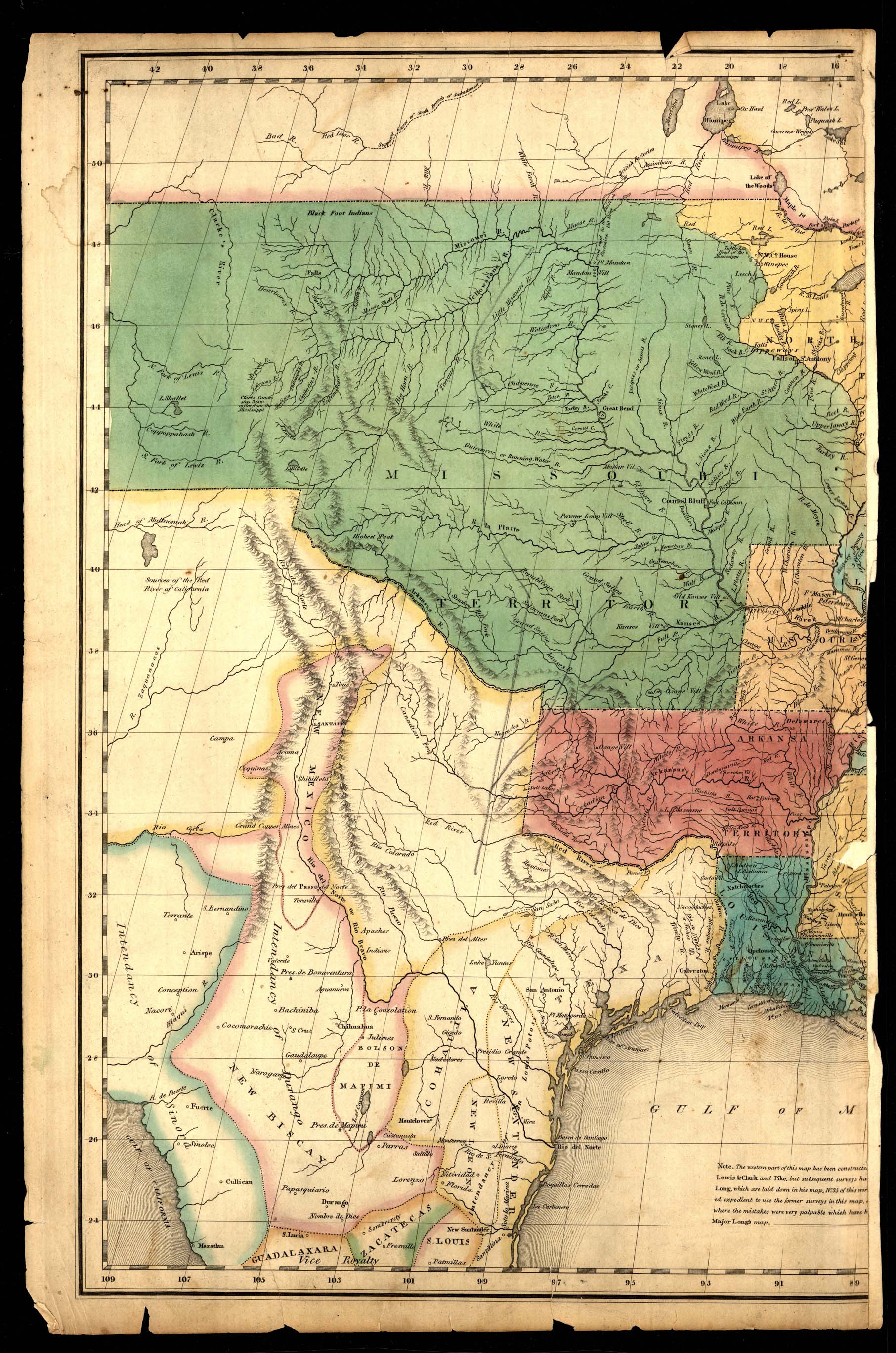
Collection: 977 M678 - [Map of of Missouri Territory]
Folder: Library
Item: 977 M678
Date: [approximately 1821]
Title: [Map of of Missouri Territory]
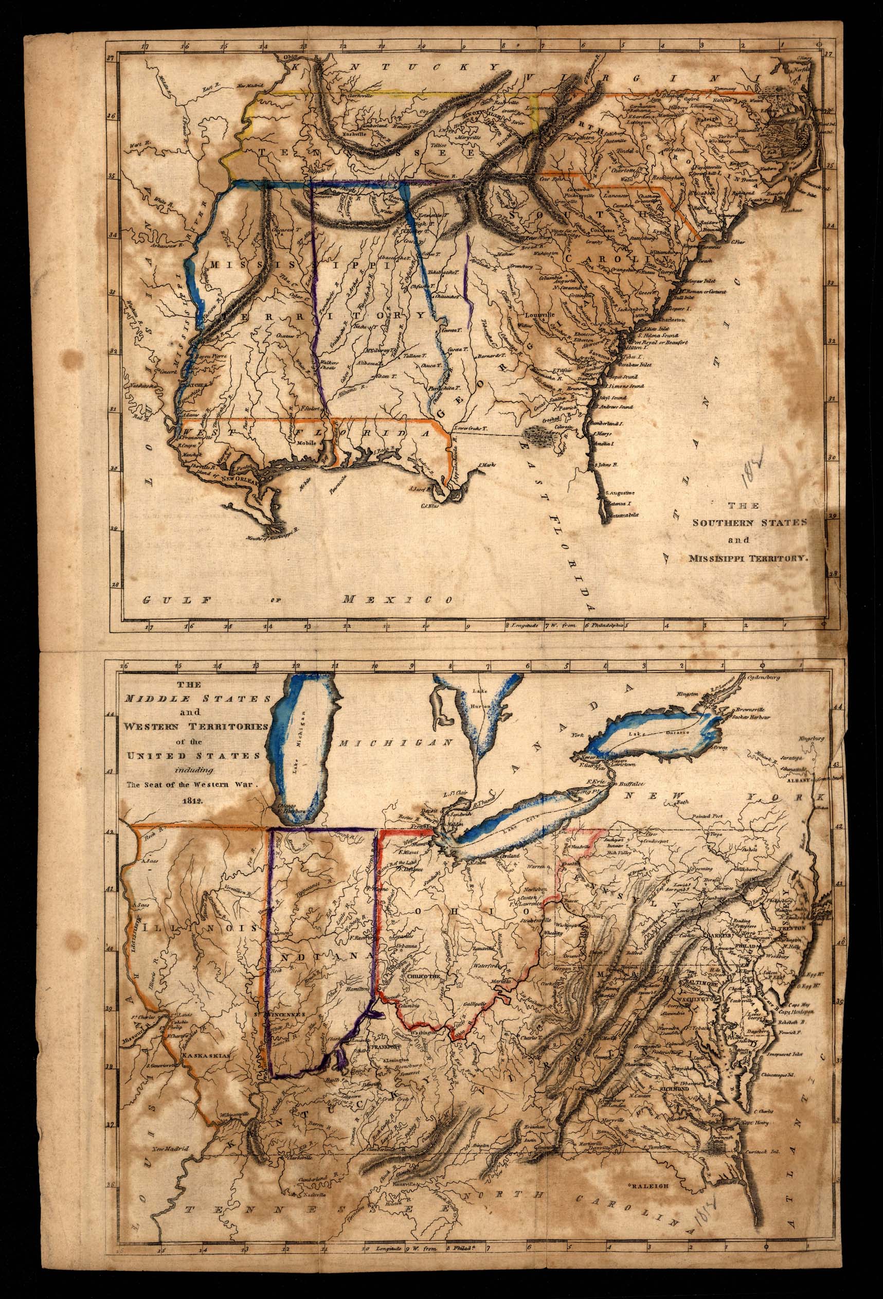
Collection: 973 M297 - [Map of the middle and southern states and territories]
Folder: Library
Item: 973 M297
Date: [approximately 1812?]
Title: [Map of the middle and southern states and territories]
Collection: 977.604 N879m - Map of Minnesota Territory
Folder: Library
Item: 977.604 N879m
Date: [1958?]
Creator: Northwestern National Life Insurance Company
Title: Map of Minnesota Territory
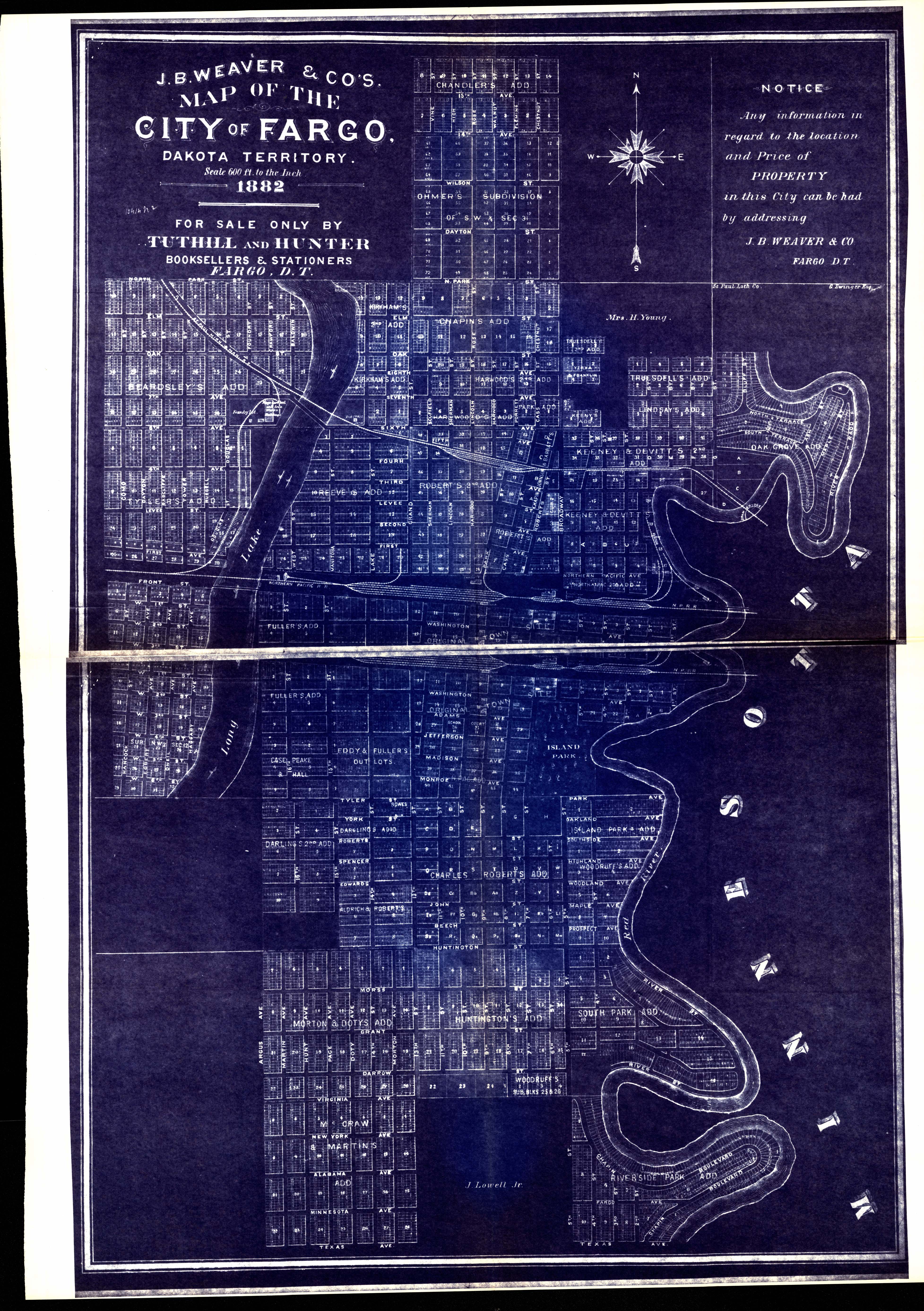
Collection: 978.413 J111m - Map of the City of Fargo, Dakota Territory, 1882
Folder: Library
Item: 978.413 J111m
Date: [1940?, 1882?]
Creator: J.B. Weaver & Co
Title: Map of the City of Fargo, Dakota Territory, 1882
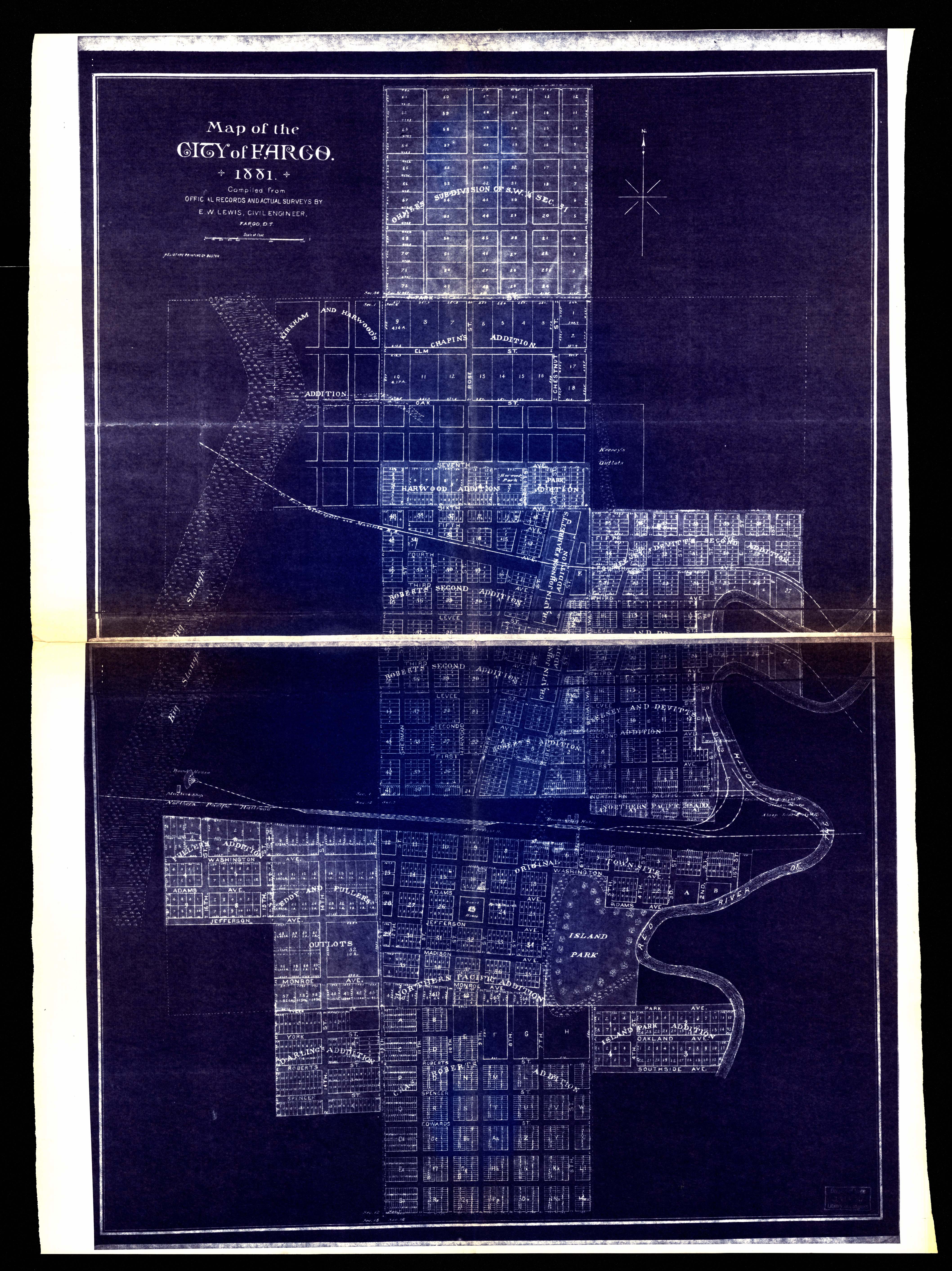
Collection: 978.413 L673m - Map of the city of Fargo, 1881/ __ __compiled from official records and actual surveys by E.W. Lewis, Civil Engineer
Folder: Library
Item: 978.413 L673m
Date: [1940?, 1881?]
Creator: Lewis, E. W
Title: Map of the city of Fargo, 1881/ __ __compiled from official records and actual surveys by E.W. Lewis, Civil Engineer
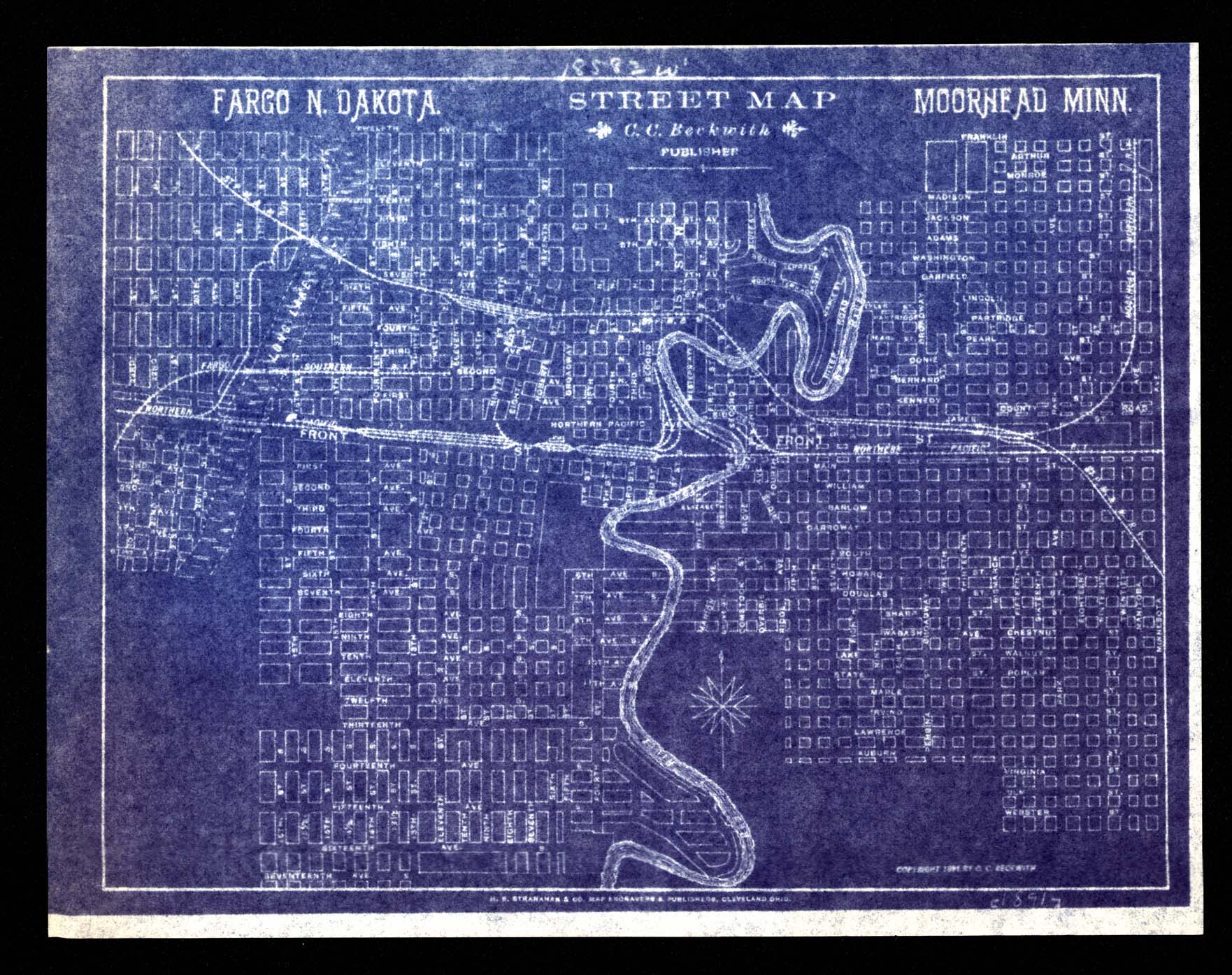
Collection: 978.413 F223s - Fargo N. Dakota street map Moorhead Minn
Folder: Library
Item: 978.413 F223s
Date: [194-?, 1891].
Title: Fargo N. Dakota street map Moorhead Minn
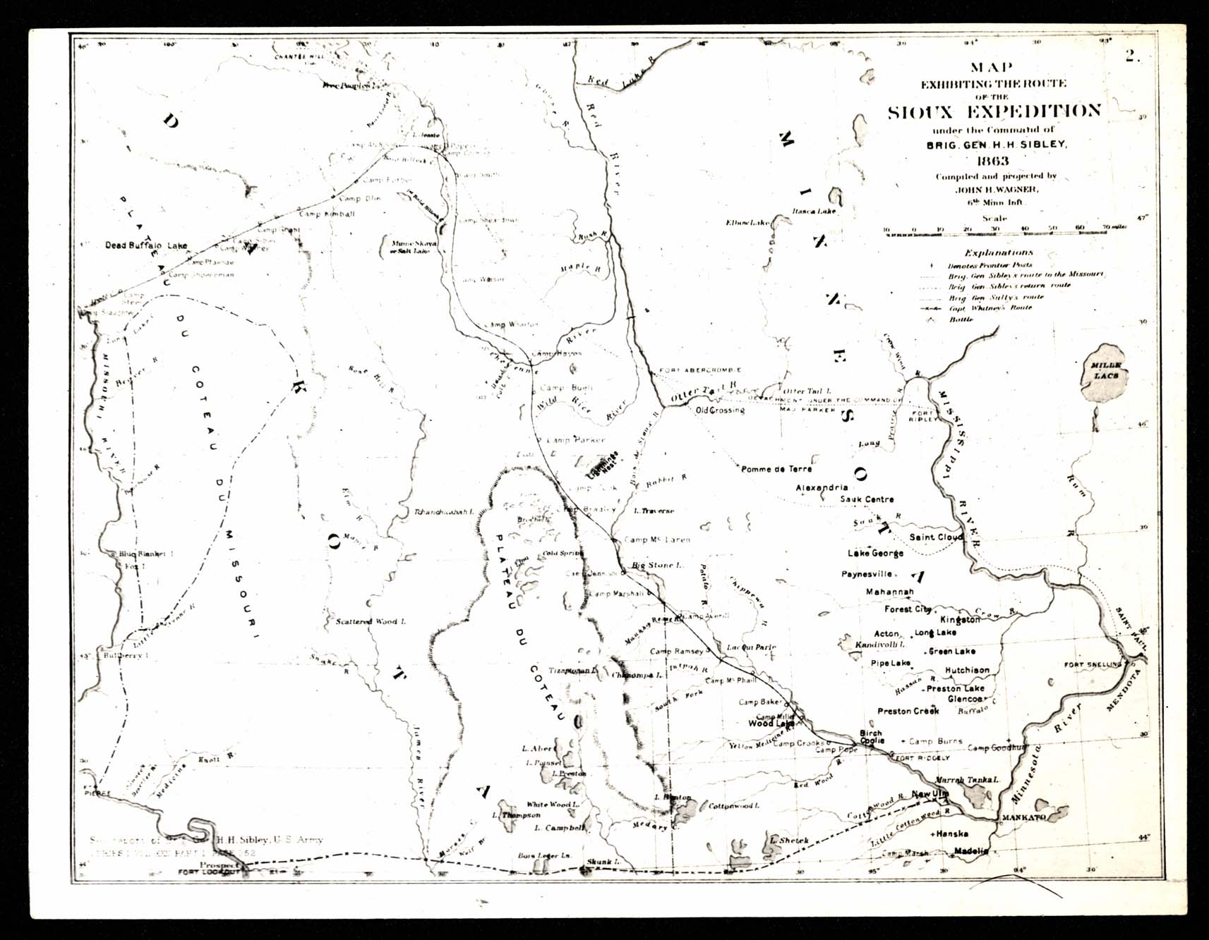
Collection: 973.7 G3263m - Map exhibiting the route of the Sioux expedition under the command of Brigadier General H.H. Sibley, 1863 / __ __compiled and projected by John H. Wagner
Folder: Library
Item: 973.7 G3263m
Date: [194-?, 1865?]
Creator: Wagner, John H
Title: Map exhibiting the route of the Sioux expedition under the command of Brigadier General H.H. Sibley, 1863 / __ __compiled and projected by John H. Wagner
Collection: 912.784 S198 Williston 1932 - Williston, Williams County, North Dakota / __ __Sanborn Map Company
Folder: Library
Item: 912.784 S198 Williston 1932
Date: [1932]
Creator: Sanborn Map Company
Title: Williston, Williams County, North Dakota / __ __Sanborn Map Company
Collection: 912.784 S198 Williston 1932 - Williston, Williams County, North Dakota / __ __Sanborn Map Company
Folder: Library
Item: 912.784 S198 Williston 1932
Date: [1932]
Creator: Sanborn Map Company
Title: Williston, Williams County, North Dakota / __ __Sanborn Map Company
Collection: 912.784 S198 Williston 1932 - Williston, Williams County, North Dakota / __ __Sanborn Map Company
Folder: Library
Item: 912.784 S198 Williston 1932
Date: [1932]
Creator: Sanborn Map Company
Title: Williston, Williams County, North Dakota / __ __Sanborn Map Company
Collection: 912.784 S198 Williston 1932 - Williston, Williams County, North Dakota / __ __Sanborn Map Company
Folder: Library
Item: 912.784 S198 Williston 1932
Date: [1932]
Creator: Sanborn Map Company
Title: Williston, Williams County, North Dakota / __ __Sanborn Map Company
Collection: 912.784 S198 Williston 1932 - Williston, Williams County, North Dakota / __ __Sanborn Map Company
Folder: Library
Item: 912.784 S198 Williston 1932
Date: [1932]
Creator: Sanborn Map Company
Title: Williston, Williams County, North Dakota / __ __Sanborn Map Company


 1932-01-jpg637055356576740565.jpg )
 1932-02-jpg637055356622198988.jpg )
 1932-03-jpg637055356672085565.jpg )
 1932-04-jpg637055356720376382.jpg )
 1932-05-jpg637055356766968775.jpg )