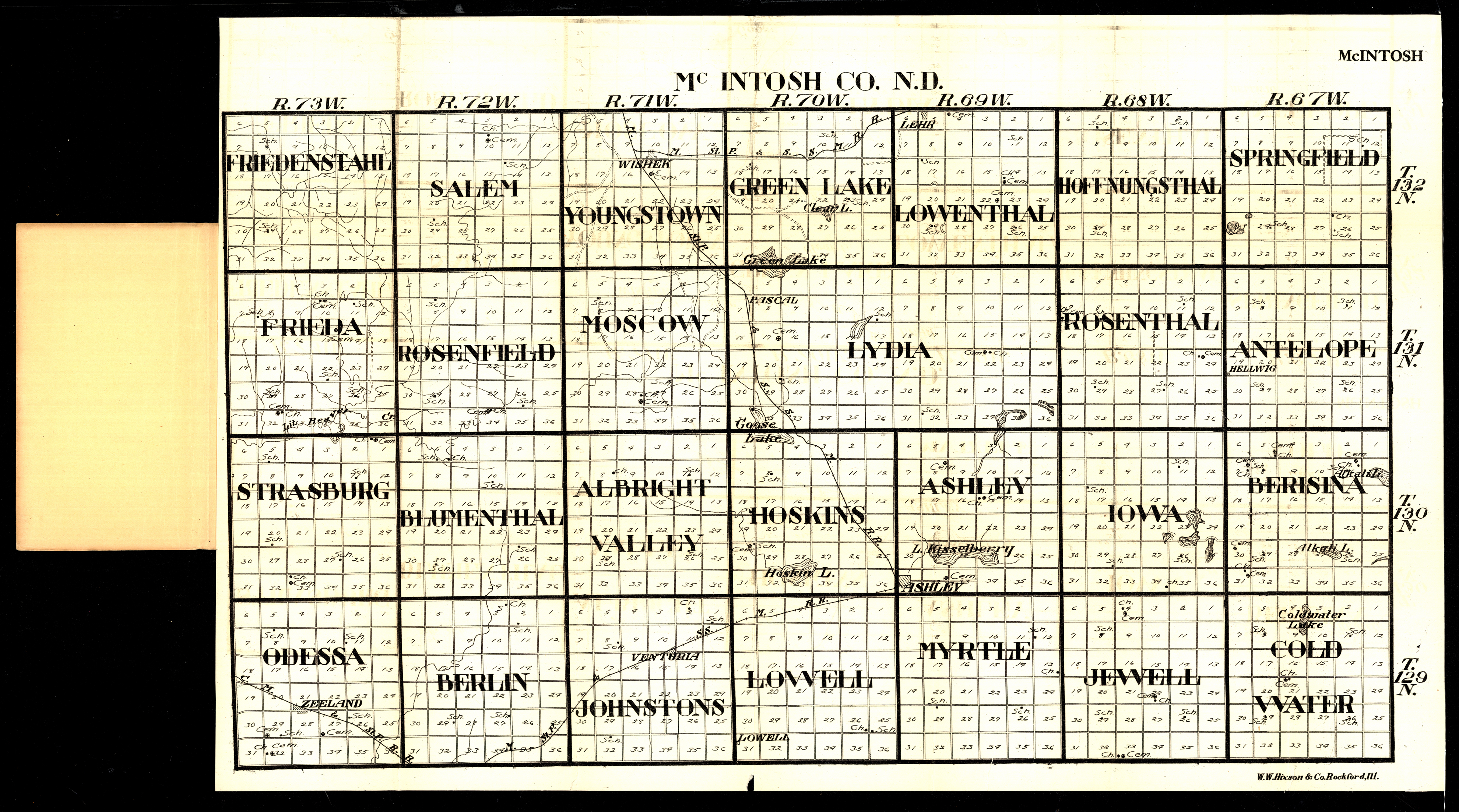
Collection: 978.455 W1117m 1916 - McIntosh Co., N.D
Folder:
Library
Item:
978.455 W1117m 1916
Date:
1916
Creator:
W.W. Hixson & Co
Title:
McIntosh Co., N.D
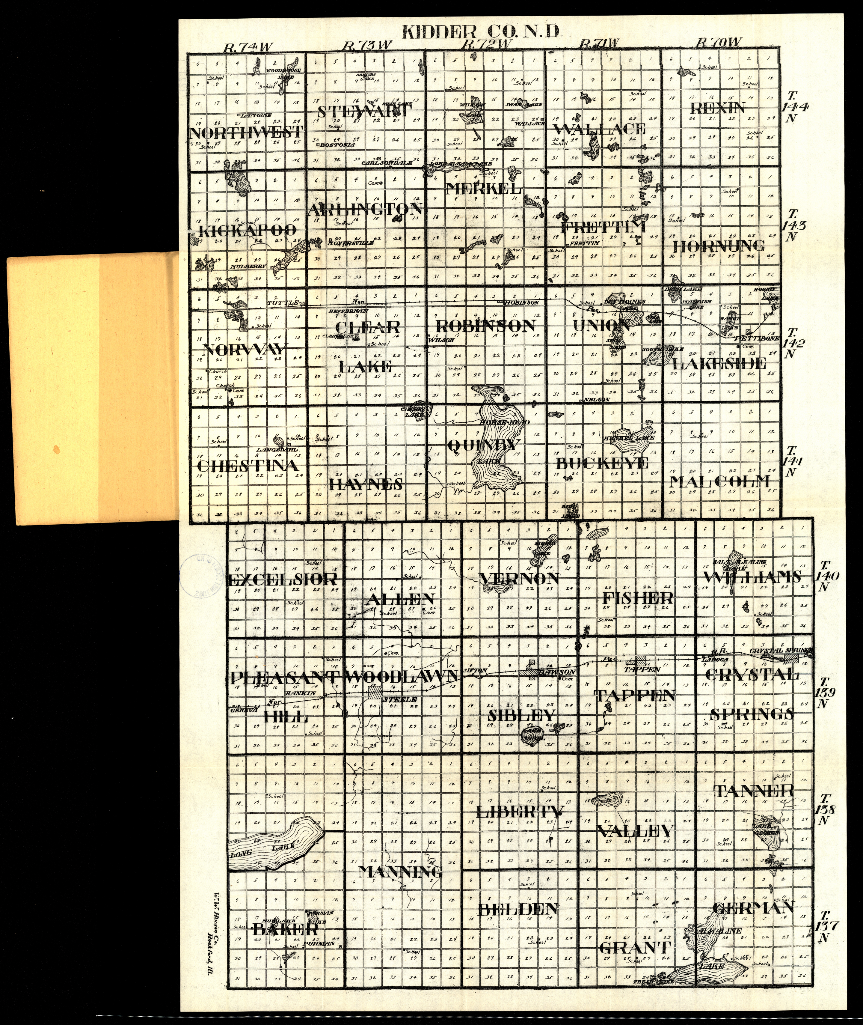
Collection: 978.457 W1117k 1916 - Kidder Co., N.D
Folder:
Library
Item:
978.457 W1117k 1916
Date:
1916
Creator:
W.W. Hixson & Co
Title:
Kidder Co., N.D
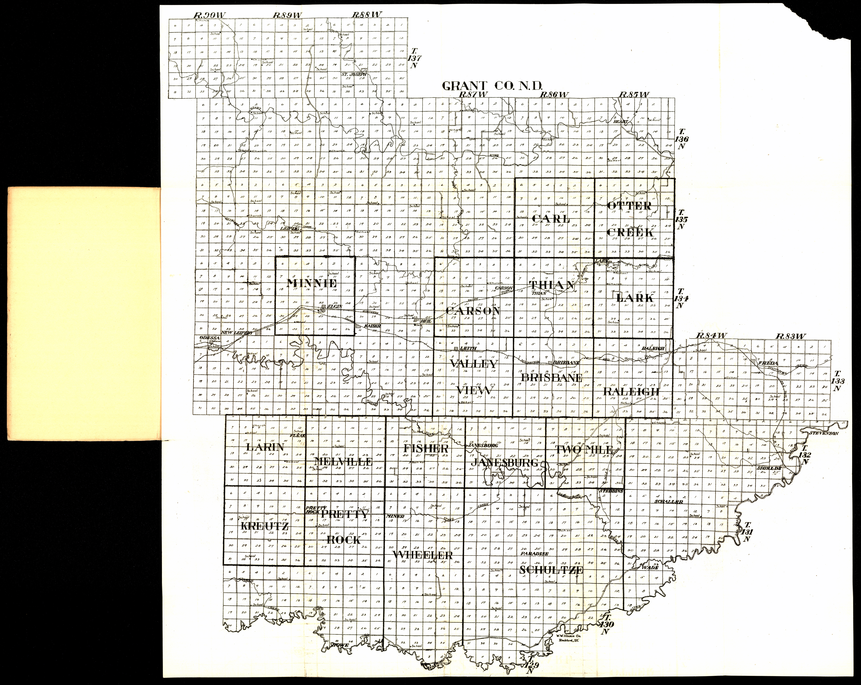
Collection: 978.487 W1117g 1916 - Grant Co., N.D
Folder:
Library
Item:
978.487 W1117g 1916
Date:
1916
Creator:
W.W. Hixson & Co
Title:
Grant Co., N.D
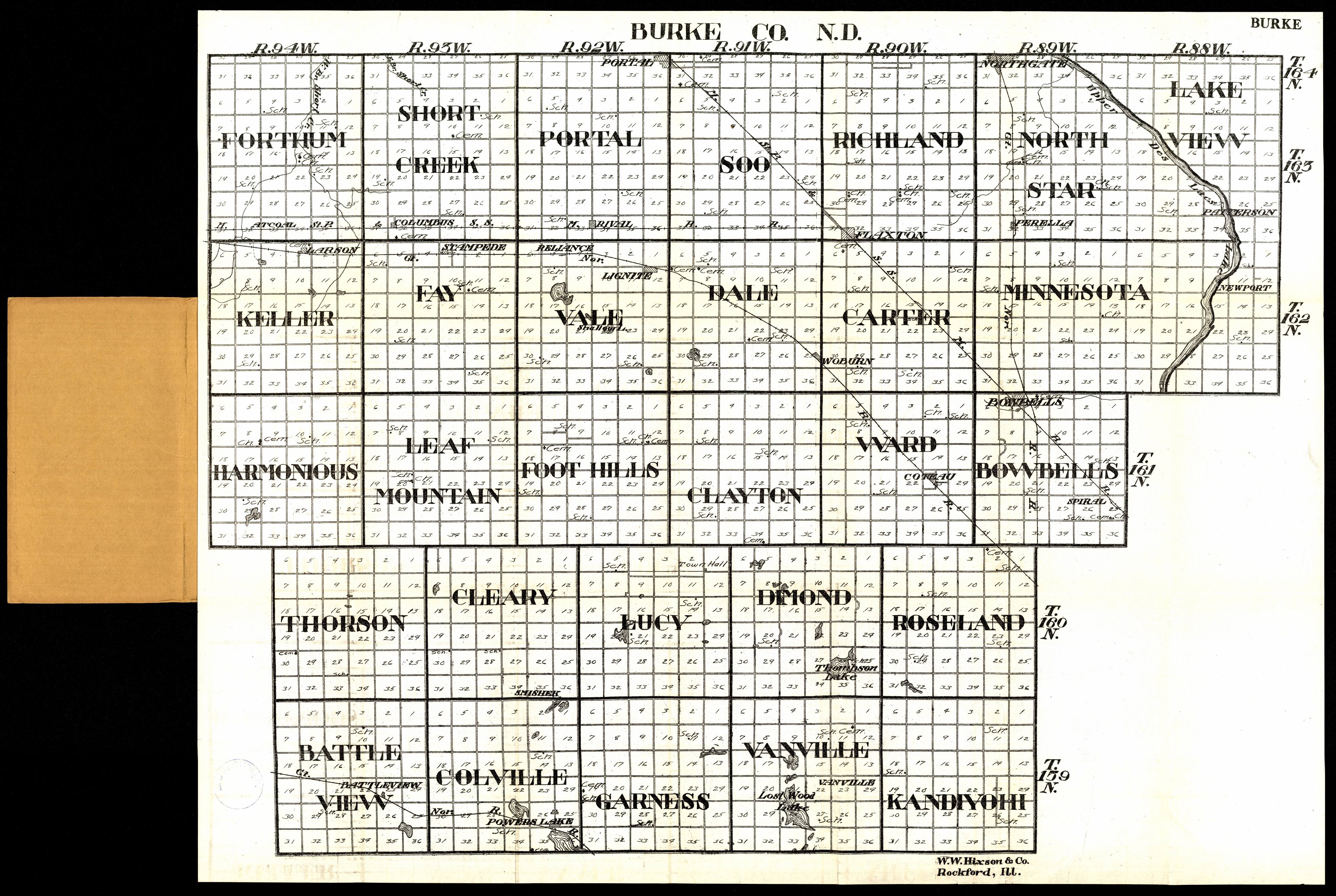
Collection: 978.472 W1117b 1916 - Burke Co., N.D
Folder:
Library
Item:
978.472 W1117b 1916
Date:
1916
Creator:
W.W. Hixson & Co
Title:
Burke Co., N.D
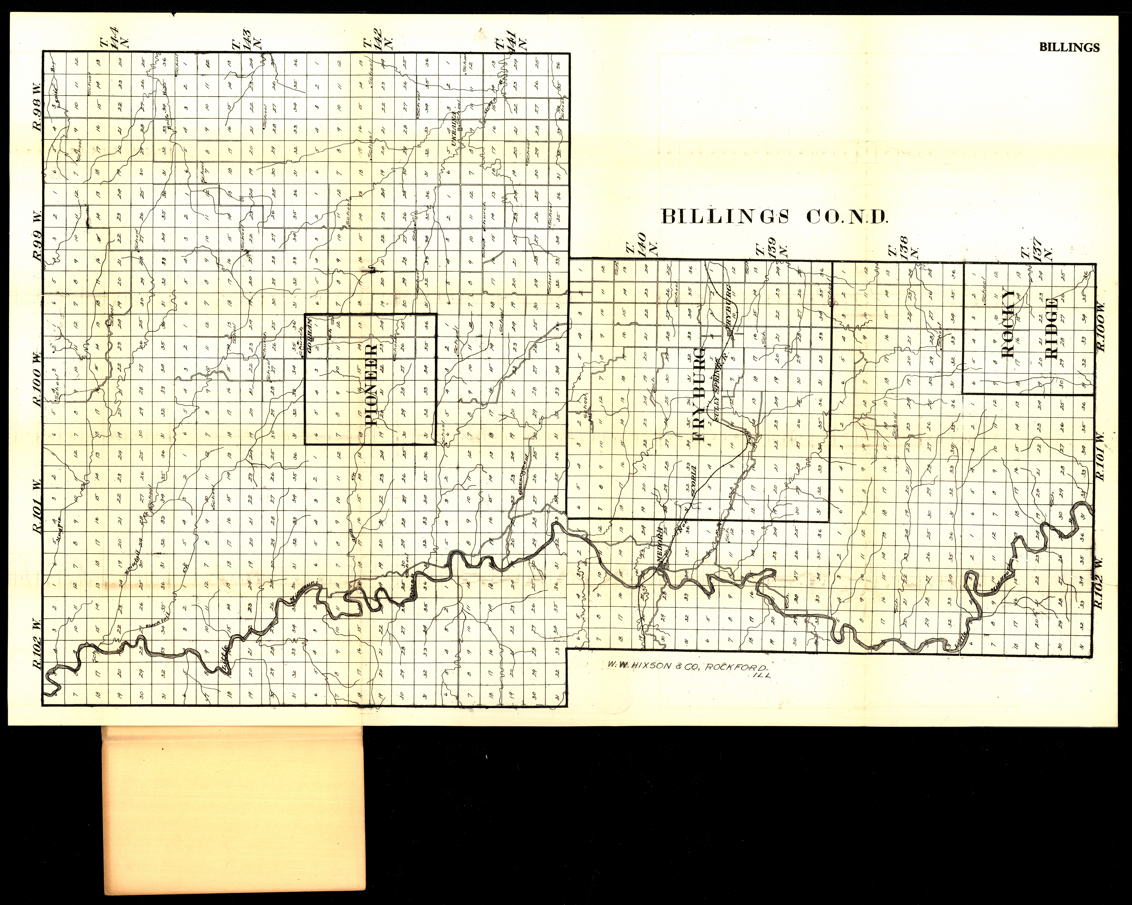
Collection: 978.494 W1117b 1916 - Billings Co., N.D
Folder:
Library
Item:
978.494 W1117b 1916
Date:
1916
Creator:
W.W. Hixson & Co
Title:
Billings Co., N.D
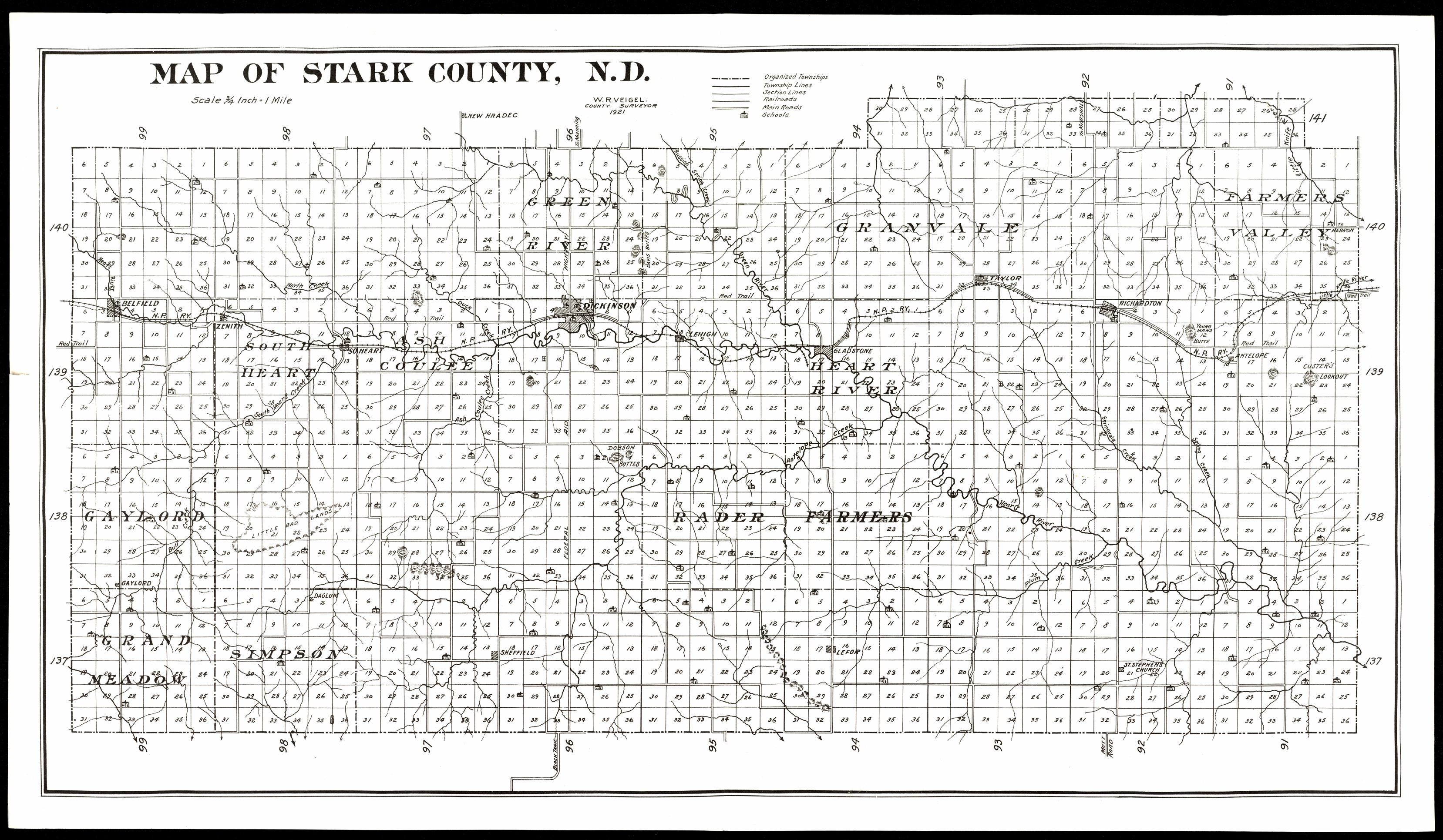
Collection: 978.4844 V426m 1921b - Map of Stark County, N.D. / __ __W.R. Veigel
Folder:
Library
Item:
978.4844 V426m 1921b
Date:
1921
Creator:
Veigel, W. R
Title:
Map of Stark County, N.D. / __ __W.R. Veigel
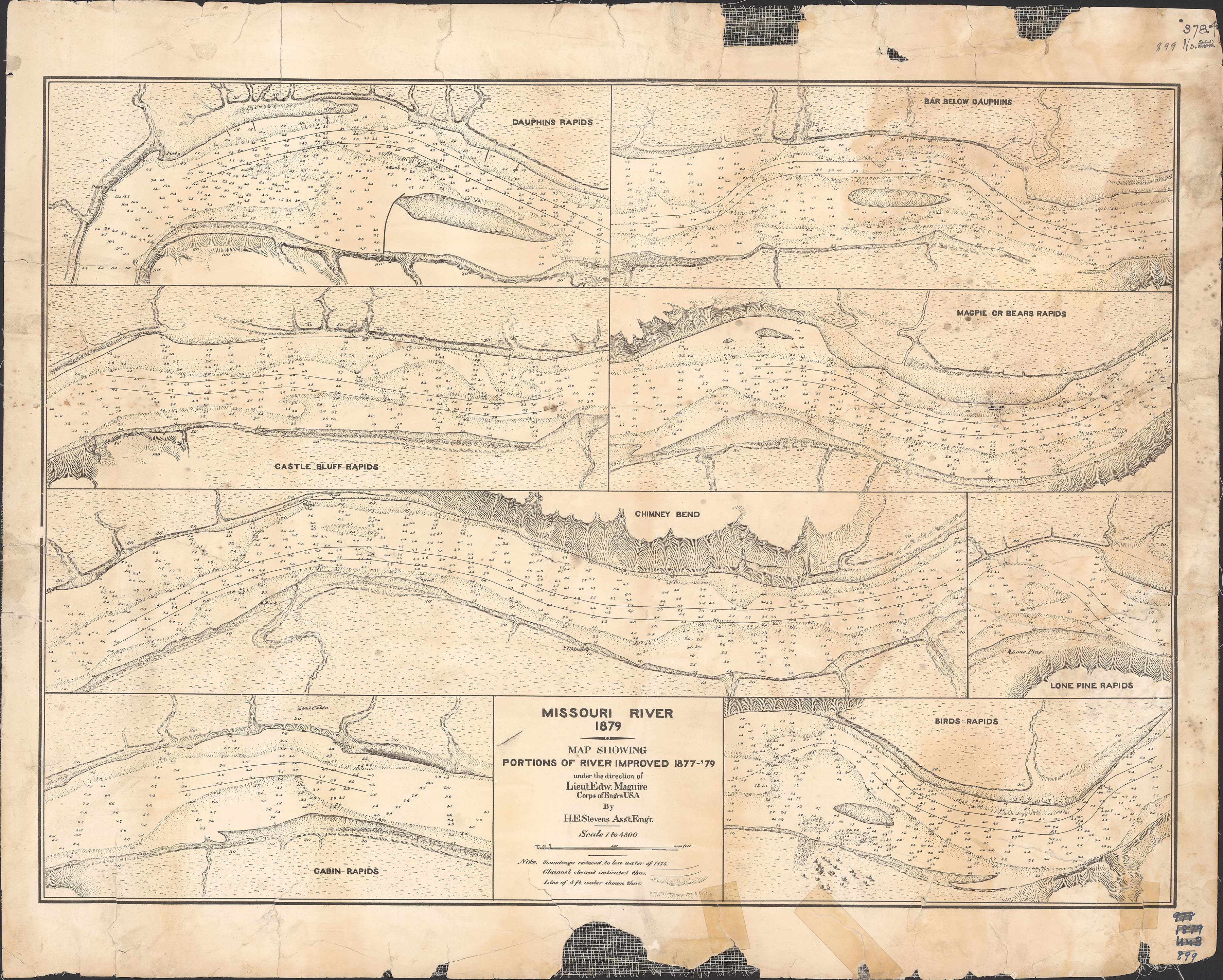
Collection: 978.6 U5813m 1879 - Missouri River, 1879 : __map showing portions of river improved 1877-'79, under the direction of Lieut. Edw. Maguire / __by H.E. Stevens
Folder:
Library
Item:
978.6 U5813m 1879
Date:
1879
Creator:
United States.--Army.--Corps of Engineers
Title:
Missouri River, 1879 : __map showing portions of river improved 1877-'79, under the direction of Lieut. Edw. Maguire / __by H.E. Stevens
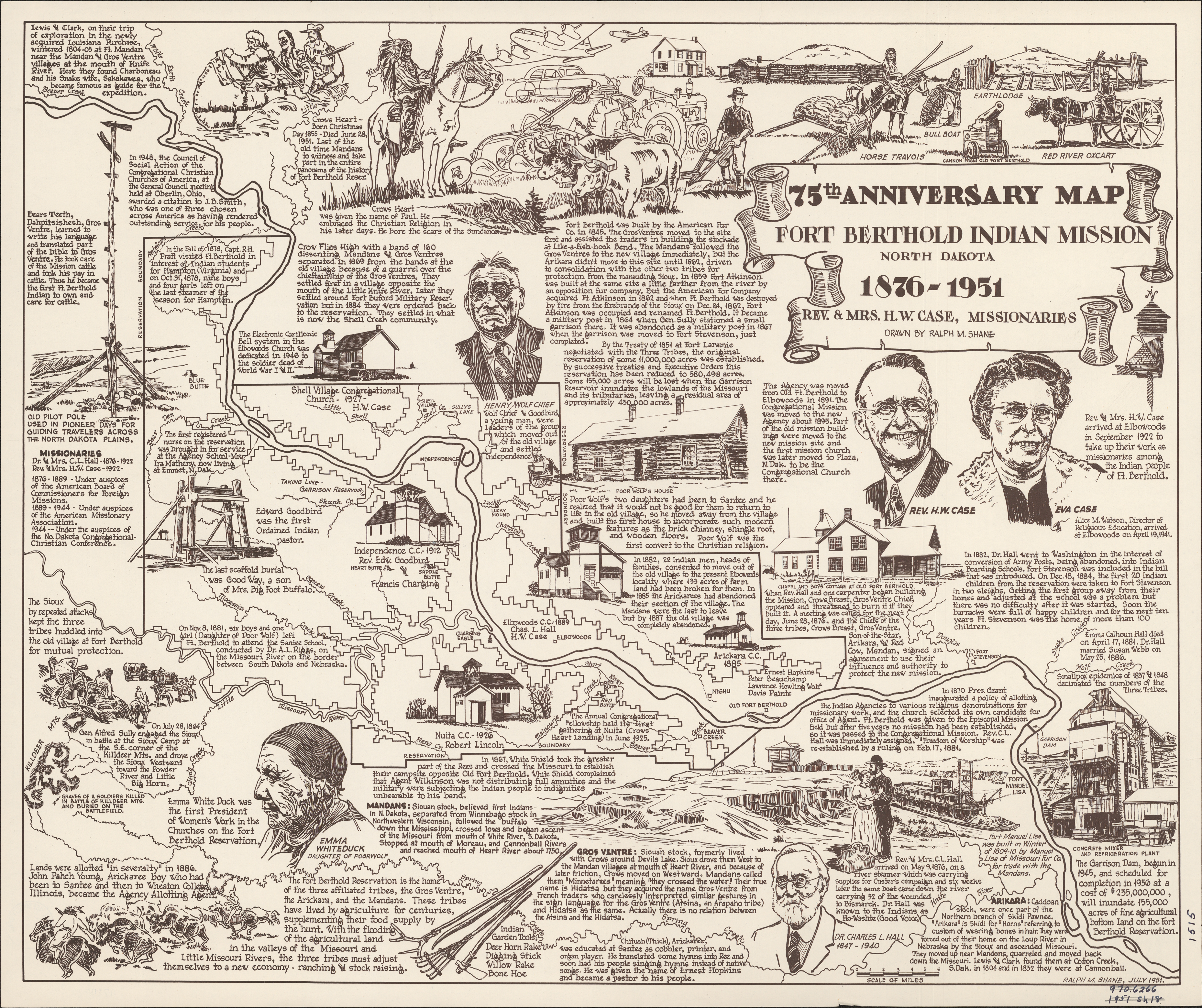
Collection: 970.6266 S5284s 1951 - 75th anniversary map, Fort Berthold Indian Mission, North Dakota, 1876-1951 / __ __drawn by Ralph M. Shane
Folder:
Library
Item:
970.6266 S5284s 1951
Date:
1951
Creator:
Shane, Ralph M
Title:
75th anniversary map, Fort Berthold Indian Mission, North Dakota, 1876-1951 / __ __drawn by Ralph M. Shane
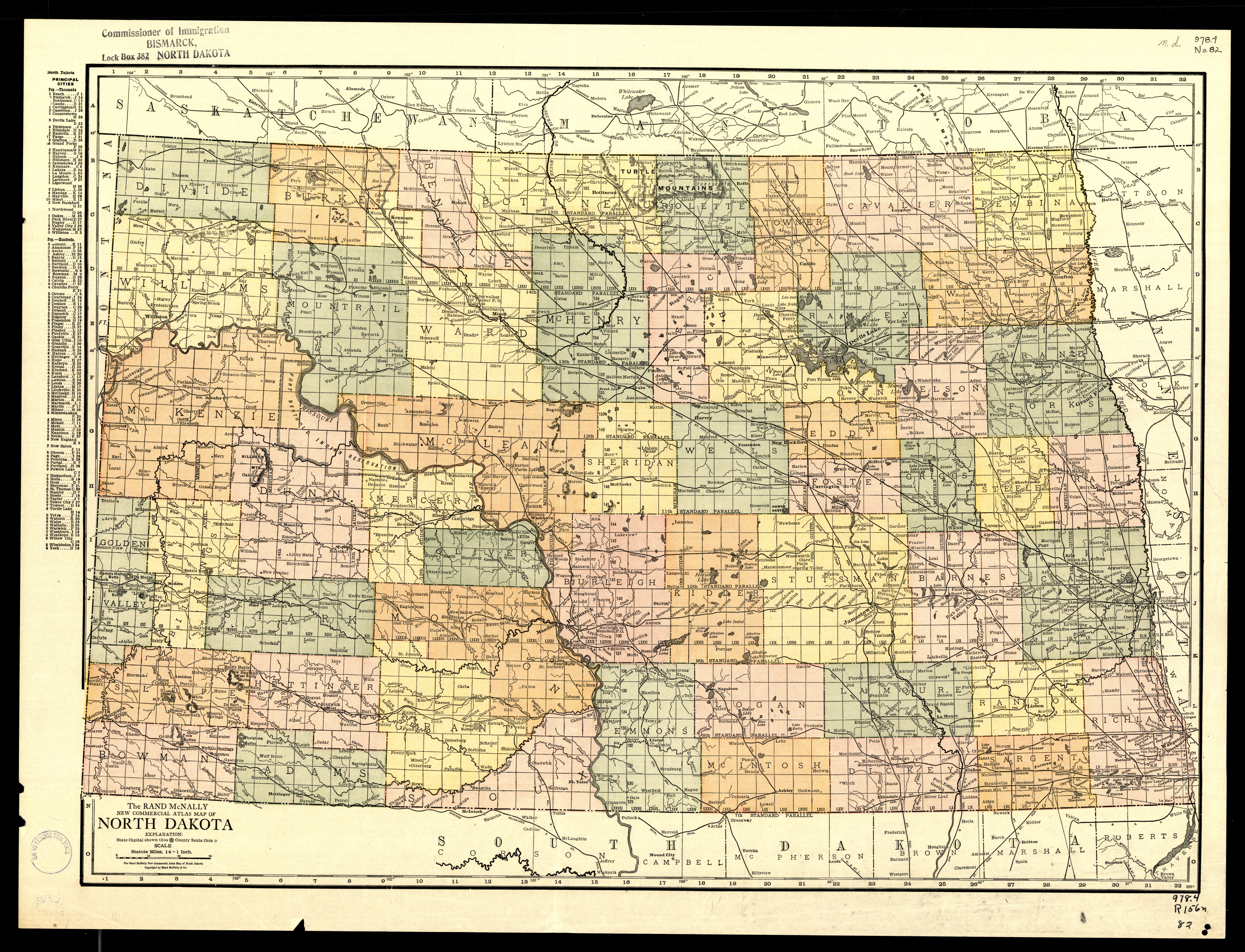
Collection: 978.4032 R186c 1918 - The Rand McNally new commercial atlas map of North Dakota
Folder:
Library
Item:
978.4032 R186c 1918
Date:
1918
Creator:
Rand McNally and Company
Title:
The Rand McNally new commercial atlas map of North Dakota
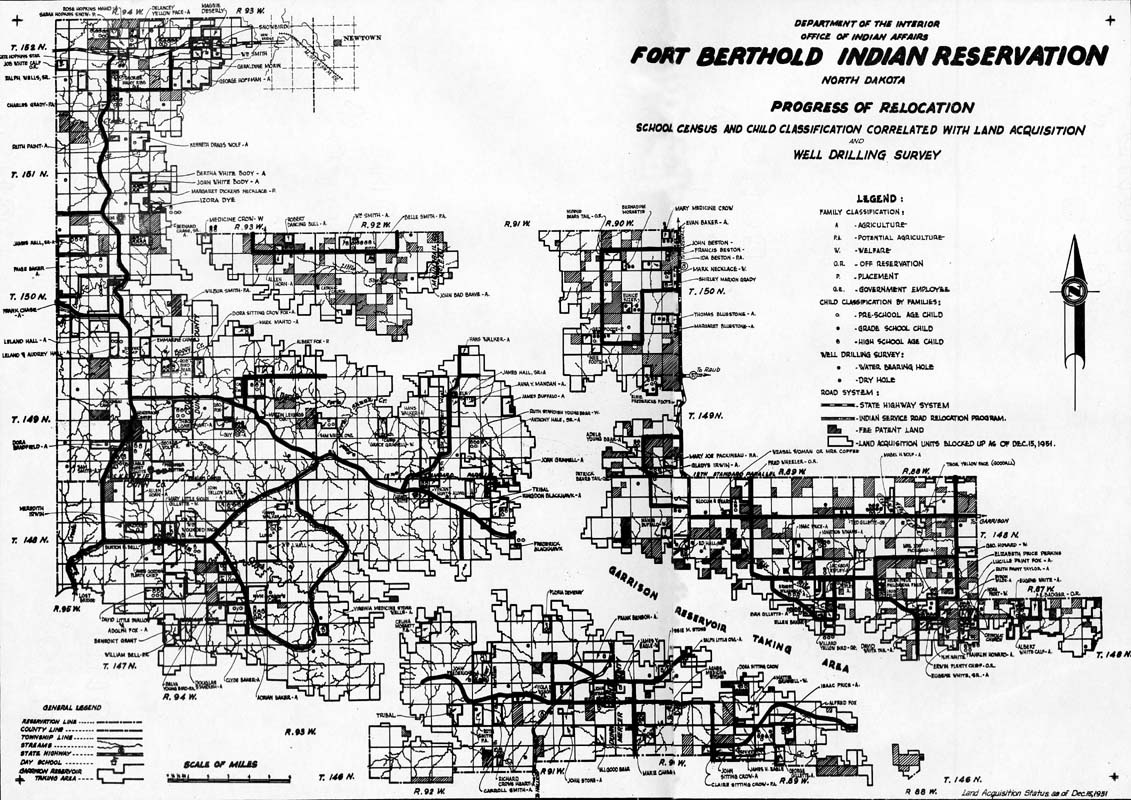
Collection: 978.47 U5813fr 1951 - Fort Berthold Indian Reservation, North Dakota : __progress of relocation / __Department of the Interior, Office of Indian Affairs
Folder:
Library
Item:
978.47 U5813fr 1951
Date:
1951
Creator:
United States.--Bureau of Indian Affairs
Title:
Fort Berthold Indian Reservation, North Dakota : __progress of relocation / __Department of the Interior, Office of Indian Affairs
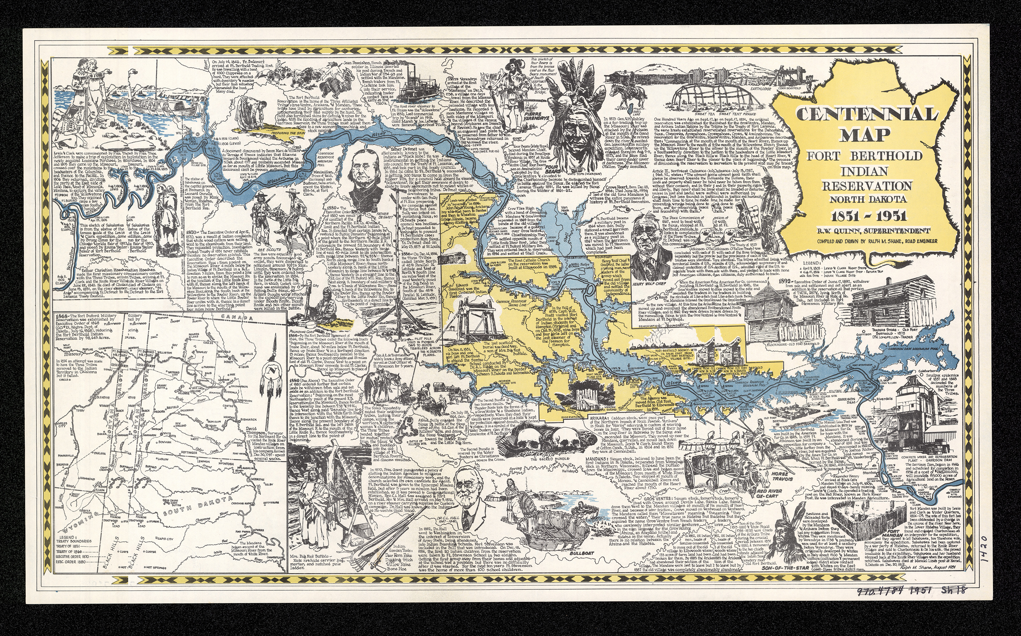
Collection: 978.47 S5284c 1951 - Centennial map, Fort Berthold Indian Reservation, North Dakota, 1851-1951 / __ __compiled and drawn by Ralph M. Shane
Folder:
Library
Item:
978.47 S5284c 1951
Date:
1951
Creator:
Shane, Ralph M
Title:
Centennial map, Fort Berthold Indian Reservation, North Dakota, 1851-1951 / __ __compiled and drawn by Ralph M. Shane
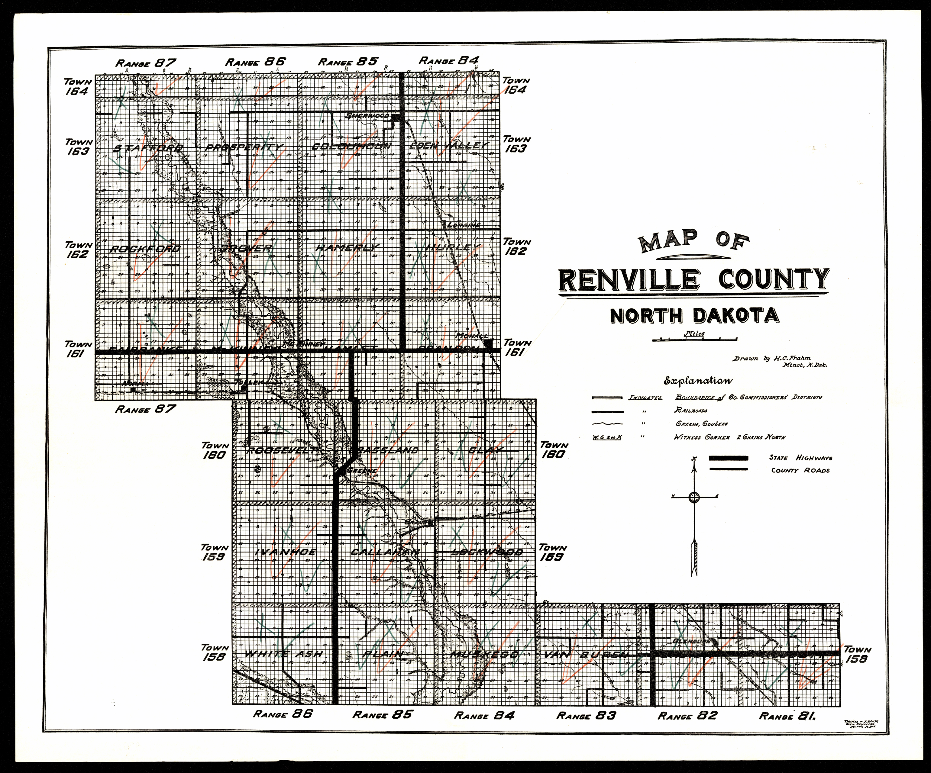
Collection: 978.464 F8m 1920 - Map of Renville County, North Dakota / __ __drawn by H.C. Frahm
Folder:
Library
Item:
978.464 F8m 1920
Date:
1920
Creator:
Frahm, H. C
Title:
Map of Renville County, North Dakota / __ __drawn by H.C. Frahm
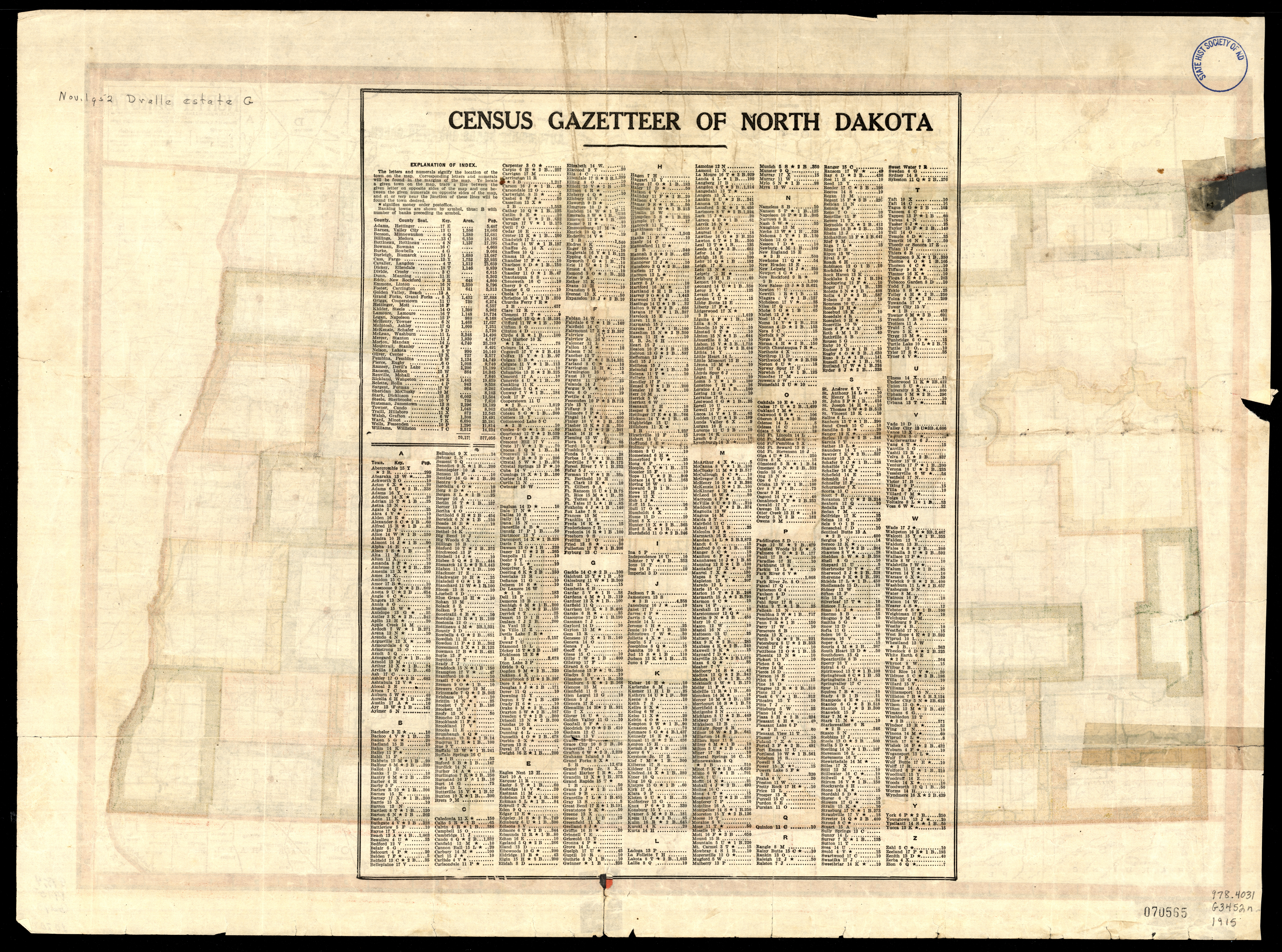
Collection: 978.4031 G3452n 1915 - North Dakota / __ __edited, engraved and published by the Geographical Publishing Co
Folder:
Library
Item:
978.4031 G3452n 1915
Date:
Copyright 1915
Creator:
Geographical Publishing Co
Title:
North Dakota / __ __edited, engraved and published by the Geographical Publishing Co
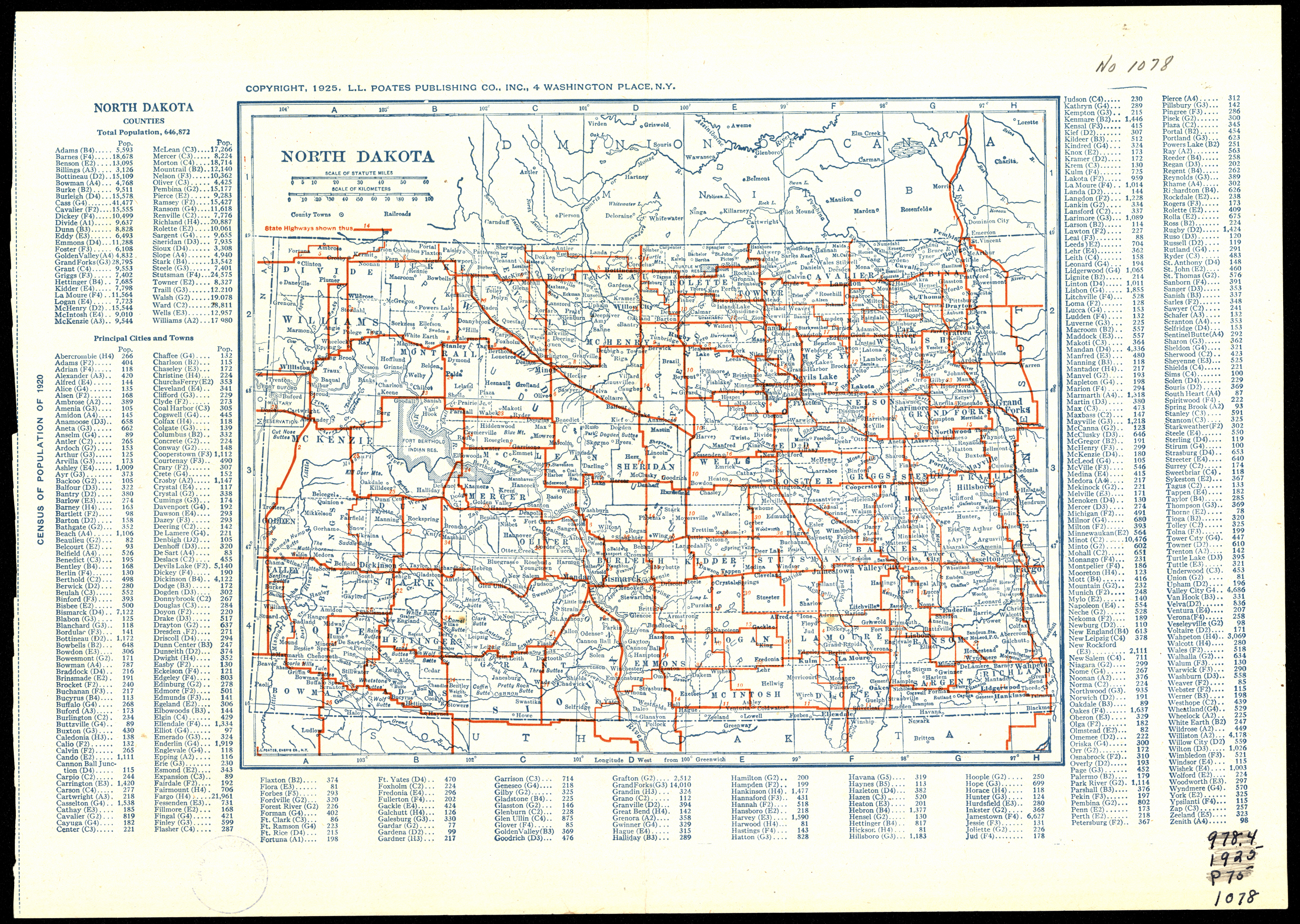
Collection: 978.4032 L1113n 1925 - North Dakota / __ __L.L. Poates Engr'g Co
Folder:
Library
Item:
978.4032 L1113n 1925
Date:
Copyright 1925
Creator:
L.L. Poates Engr'g Co
Title:
North Dakota / __ __L.L. Poates Engr'g Co
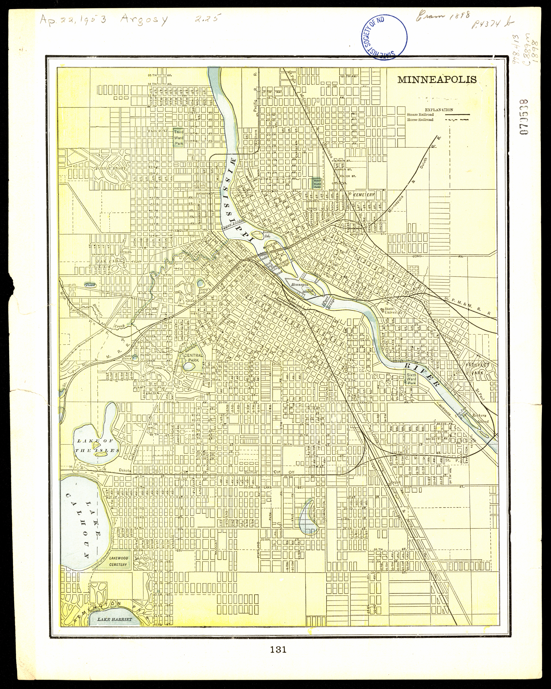
Collection: 978.413 C889m 1898 - Map of the City of Fargo, Cass County, North Dakota / __ __Geo. F. Cram, engraver and publisher
Folder:
Library
Item:
978.413 C889m 1898
Date:
1898
Creator:
Cram, George Franklin,--1841-1928
Title:
Map of the City of Fargo, Cass County, North Dakota / __ __Geo. F. Cram, engraver and publisher
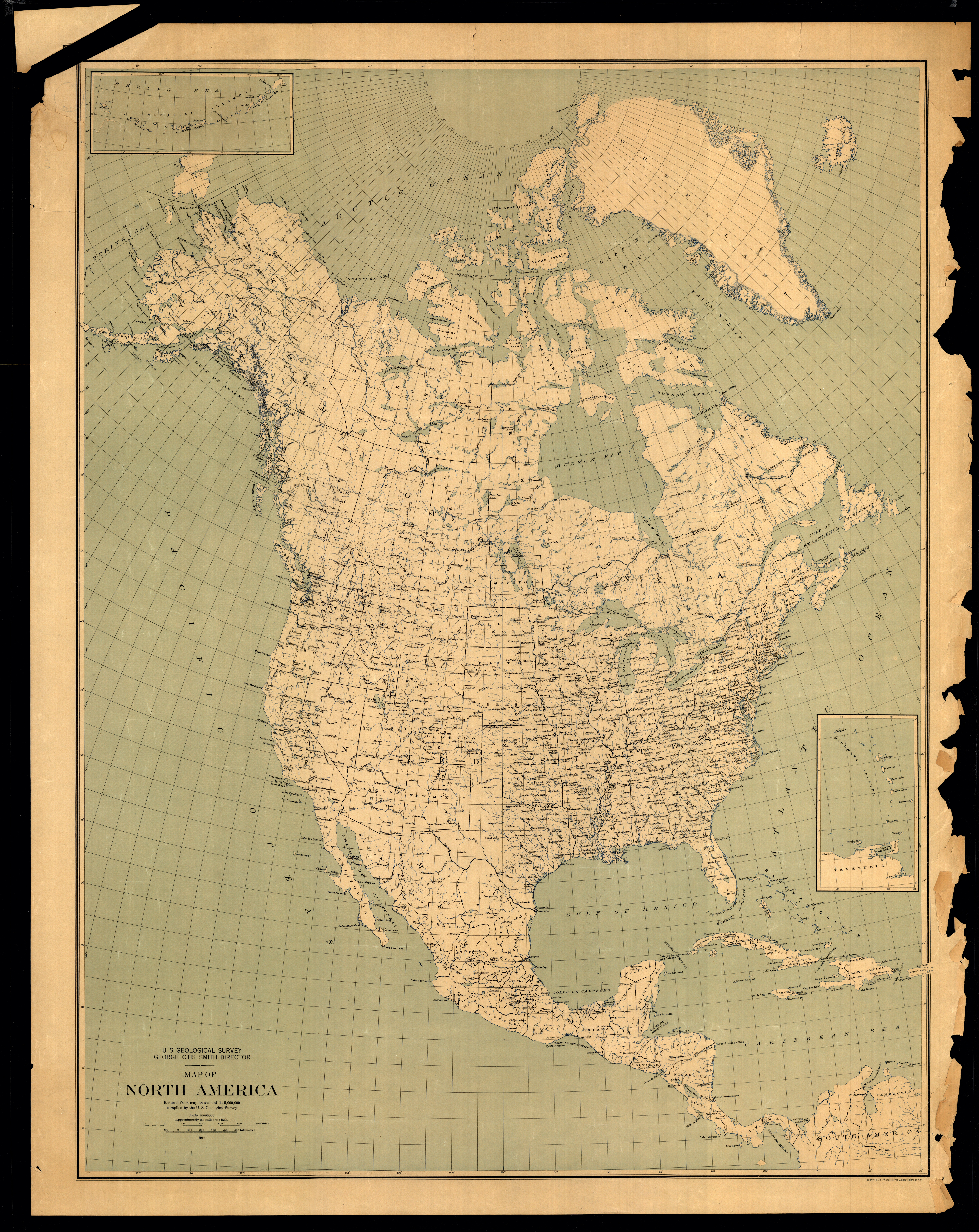
Collection: 970 G345m 1912 - Map of North America : __reduced from map on scale of 1:5,000,000 / __compiled by the U.S. Geological Survey
Folder:
Library
Item:
970 G345m 1912
Date:
1912
Creator:
Geological Survey (U.S.)
Title:
Map of North America : __reduced from map on scale of 1:5,000,000 / __compiled by the U.S. Geological Survey
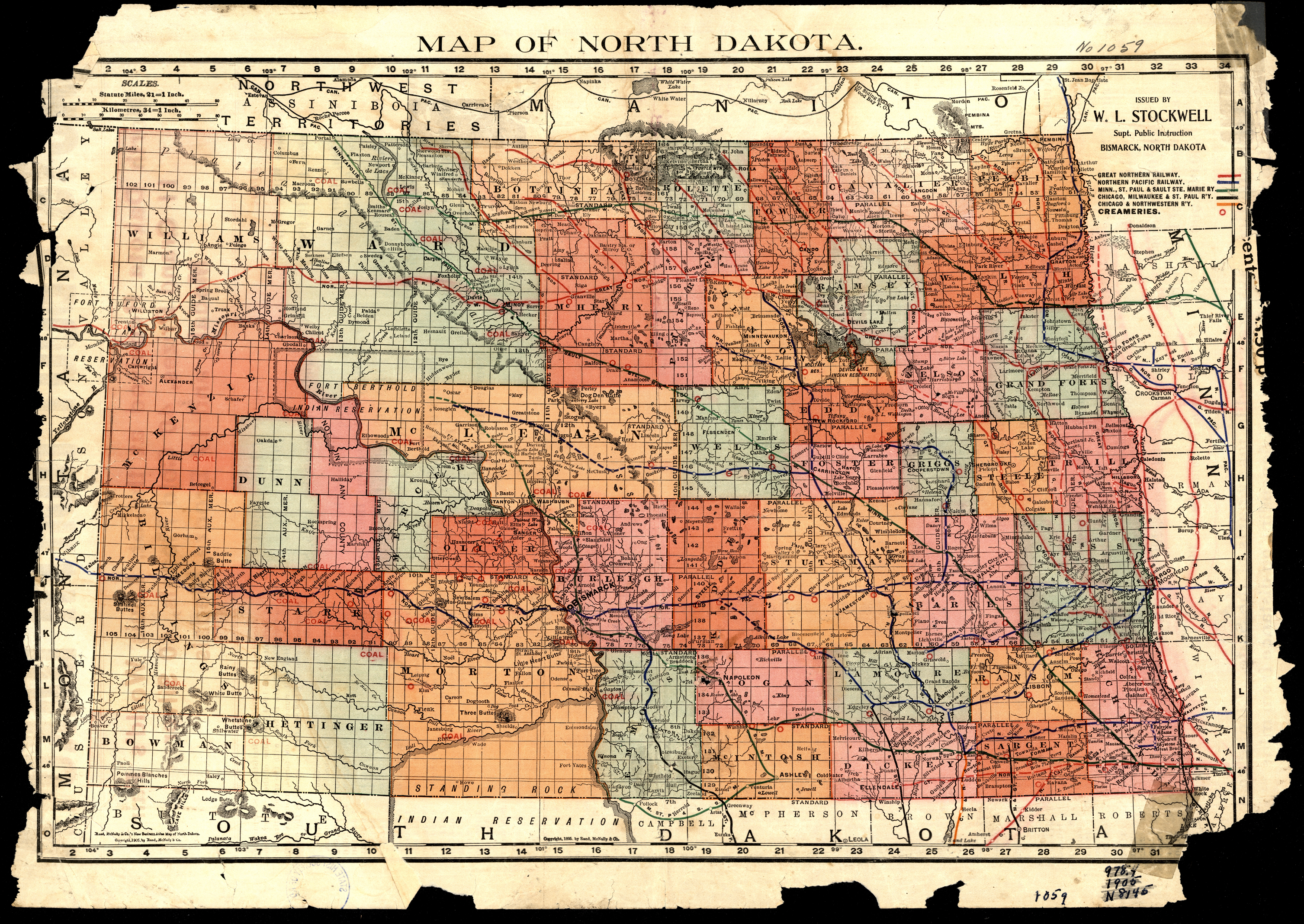
Collection: 978.4031 N864 1905b - Map of North Dakota / __ __issued by W.L. Stockwell, Supt. Public Instruction
Folder:
Library
Item:
978.4031 N864 1905b
Date:
Copyright 1905
Creator:
North Dakota.--Department of Public Instruction
Title:
Map of North Dakota / __ __issued by W.L. Stockwell, Supt. Public Instruction
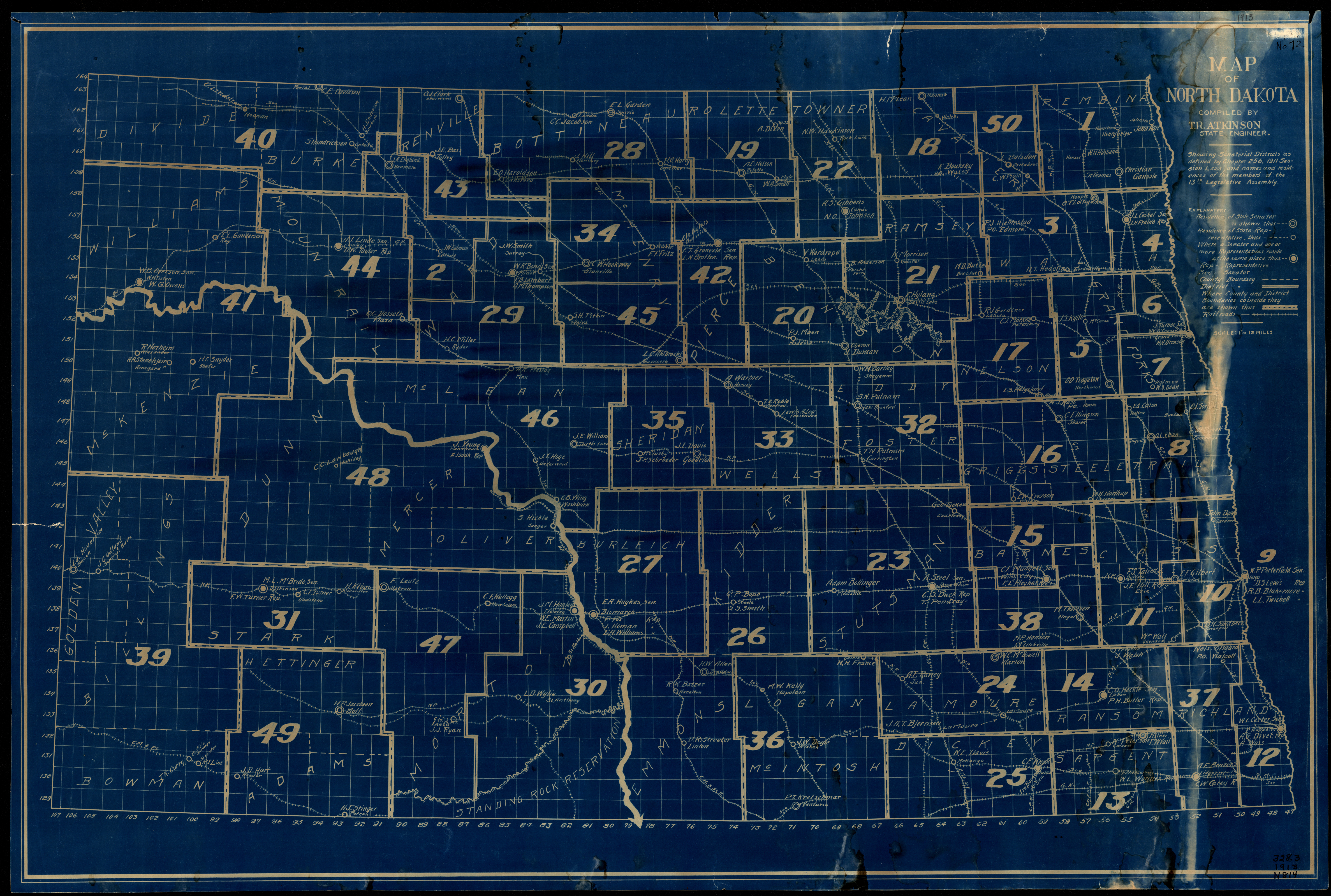
Collection: 328.3345 M297 1913 - Map of North Dakota / __ __compiled by T.R. Atkinson, State Engineer
Folder:
Library
Item:
328.3345 M297 1913
Date:
1913
Creator:
Title:
Map of North Dakota / __ __compiled by T.R. Atkinson, State Engineer
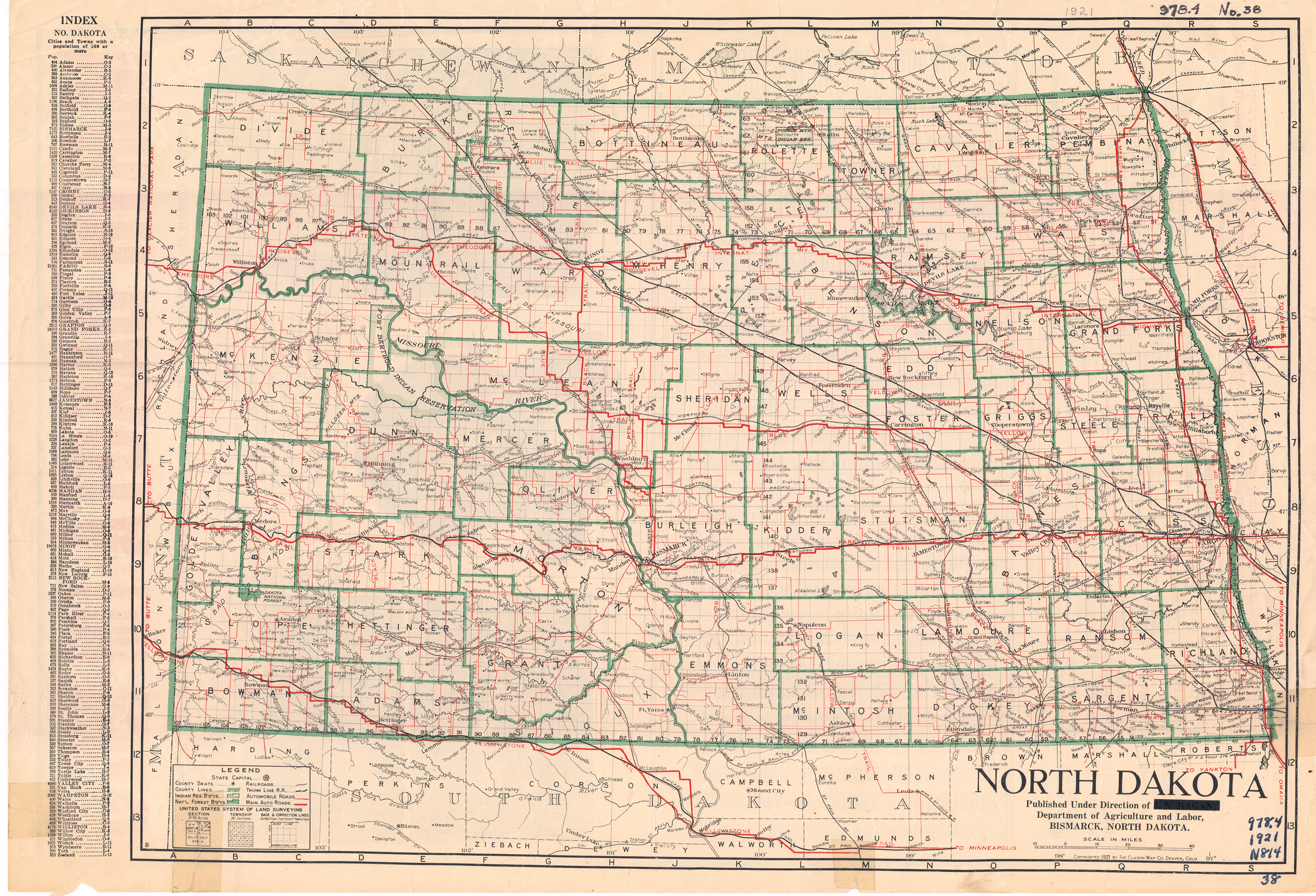
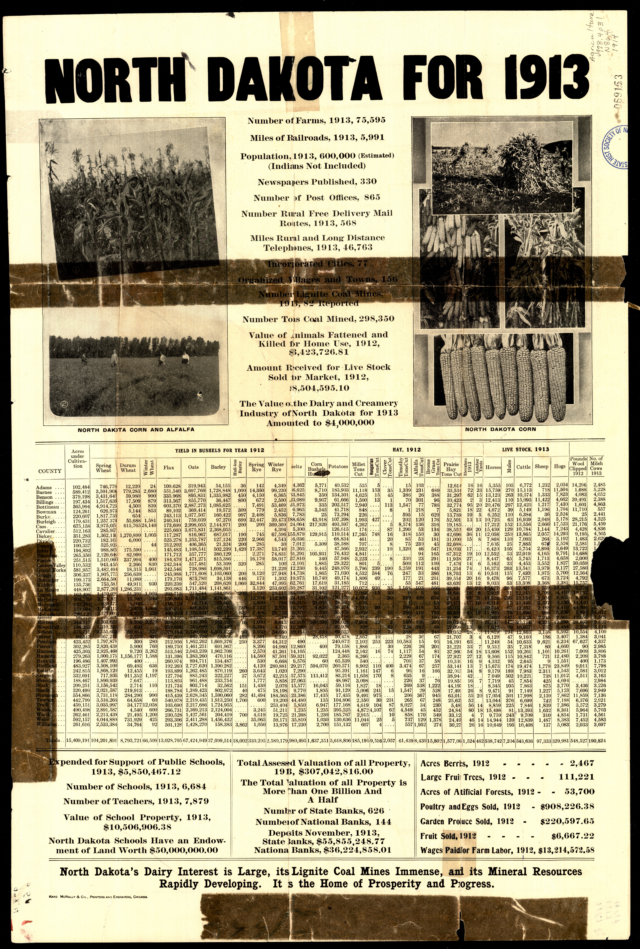
Collection: 978.4032 N864 1918 - North Dakota / __ __published under direction of J.N. Hagan, Department of Agriculture and Labor
Folder:
Library
Item:
978.4032 N864 1918
Date:
1918
Creator:
North Dakota.--Department of Agriculture and Labor
Title:
North Dakota / __ __published under direction of J.N. Hagan, Department of Agriculture and Labor
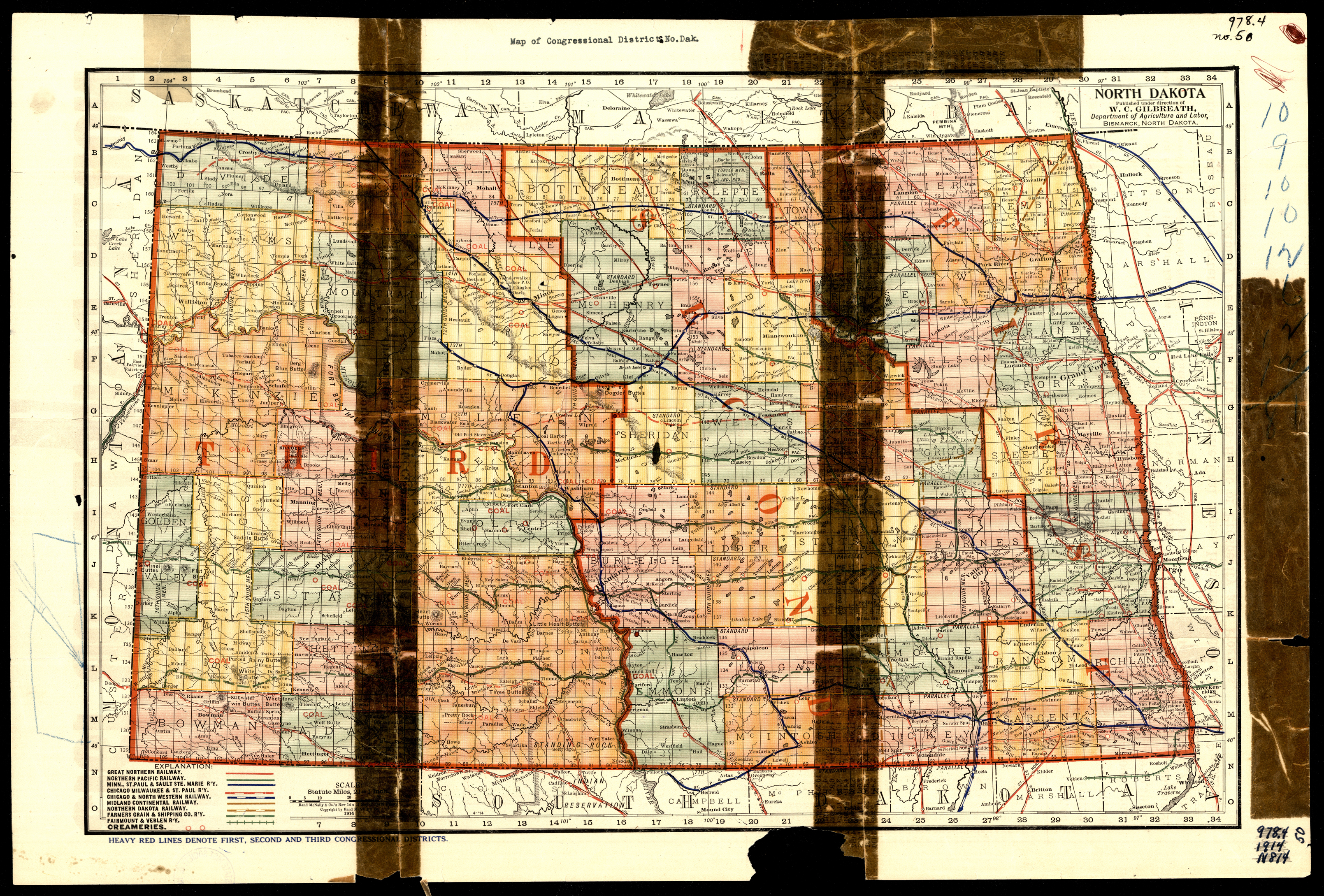
Collection: 978.4031 N864 1914 - North Dakota / __ __published under direction of W.C. Gilbreath, Department of Agriculture and Labor
Folder:
Library
Item:
978.4031 N864 1914
Date:
1914
Creator:
North Dakota.--Department of Agriculture and Labor
Title:
North Dakota / __ __published under direction of W.C. Gilbreath, Department of Agriculture and Labor
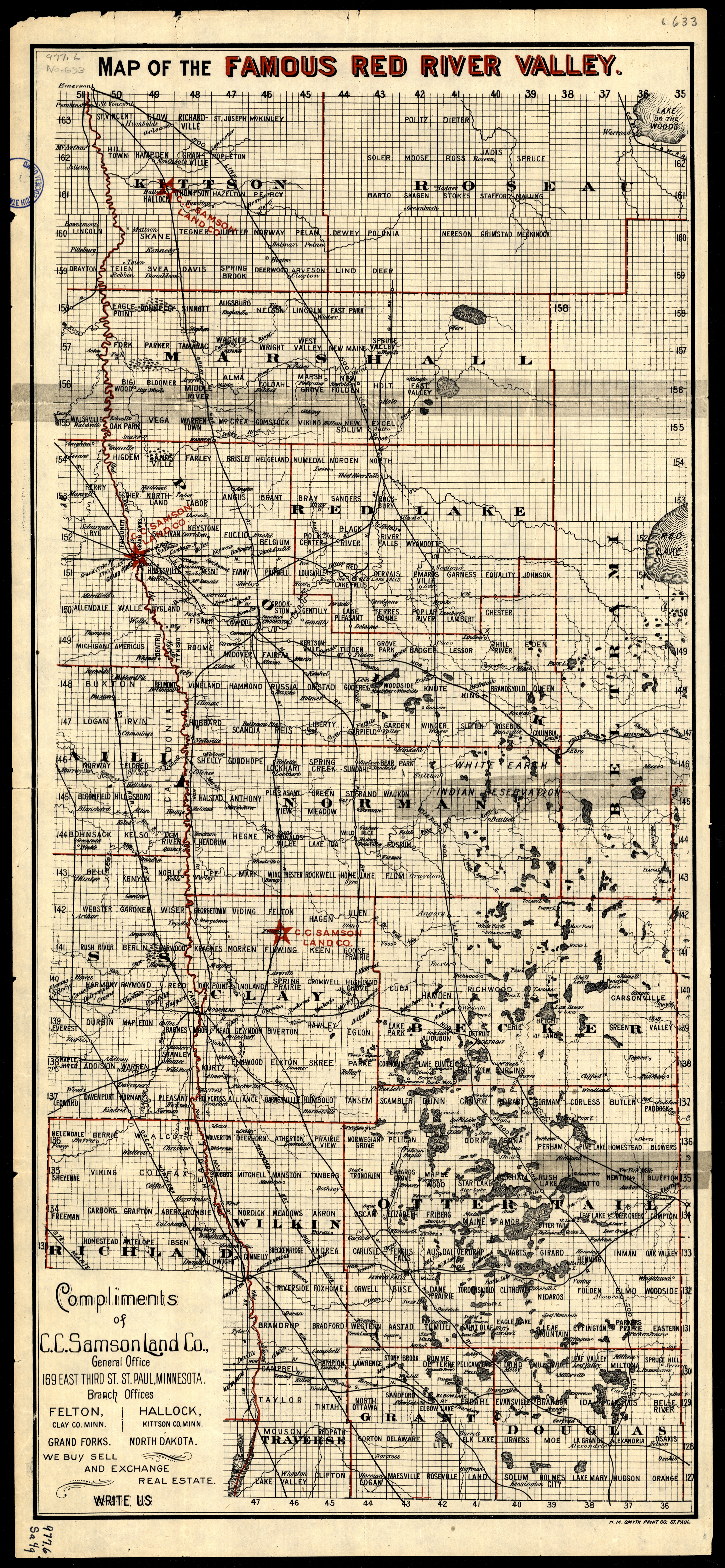
Collection: 978.41 M297r - Map of the famous Red River Valley / __ __compliments of C.C. Samson Land Co
Folder:
Library
Item:
978.41 M297r
Date:
ca. 1900- ca. 1999
Creator:
Title:
Map of the famous Red River Valley / __ __compliments of C.C. Samson Land Co
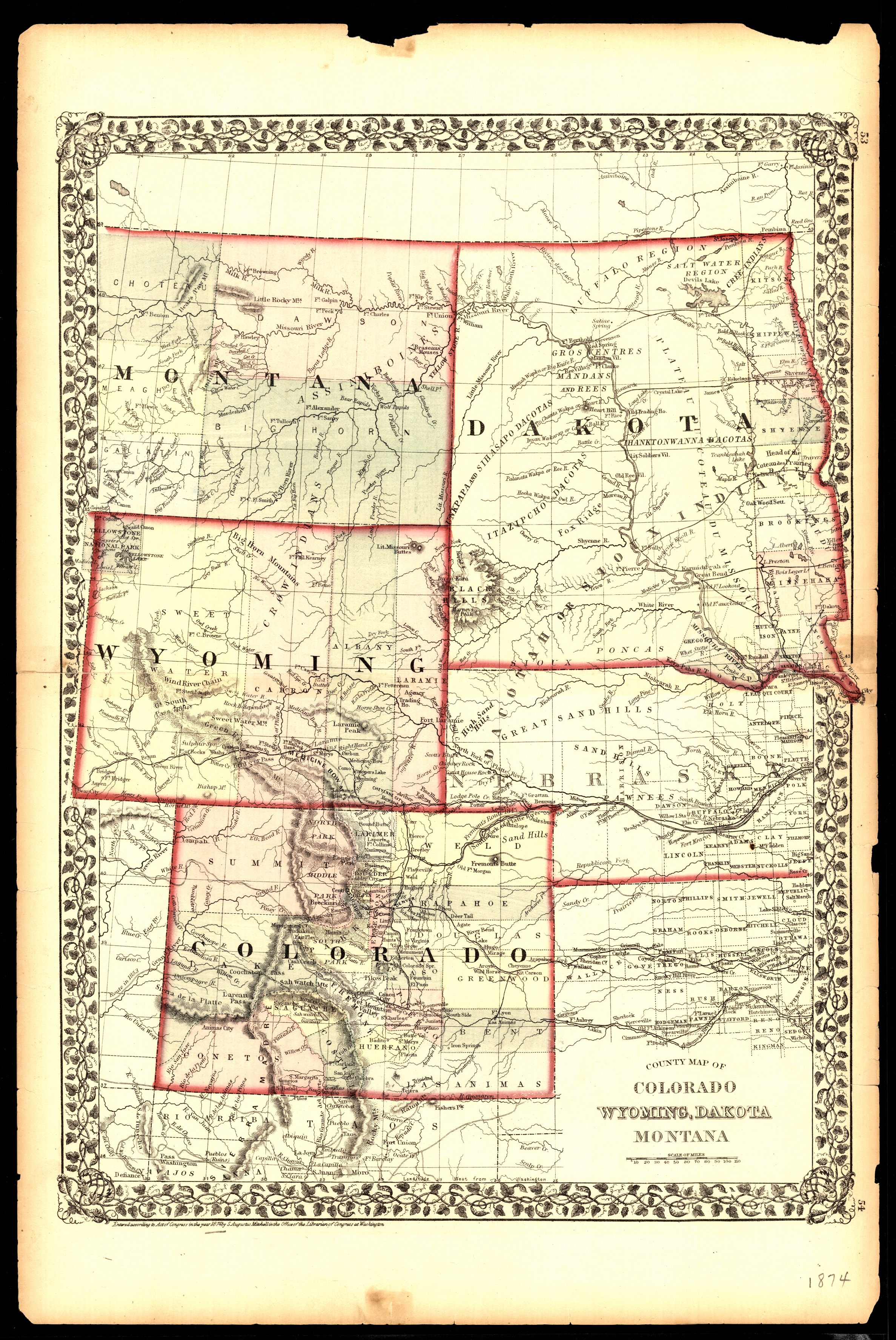
Collection: 978.402 M68c 1874 - County map of Colorado, Wyoming, Dakota, Montana / __ __S. Augustus Mitchell
Folder:
Library
Item:
978.402 M68c 1874
Date:
1874
Creator:
Mitchell, S. Augustus--(Samuel Augustus),--1792-1868
Title:
County map of Colorado, Wyoming, Dakota, Montana / __ __S. Augustus Mitchell
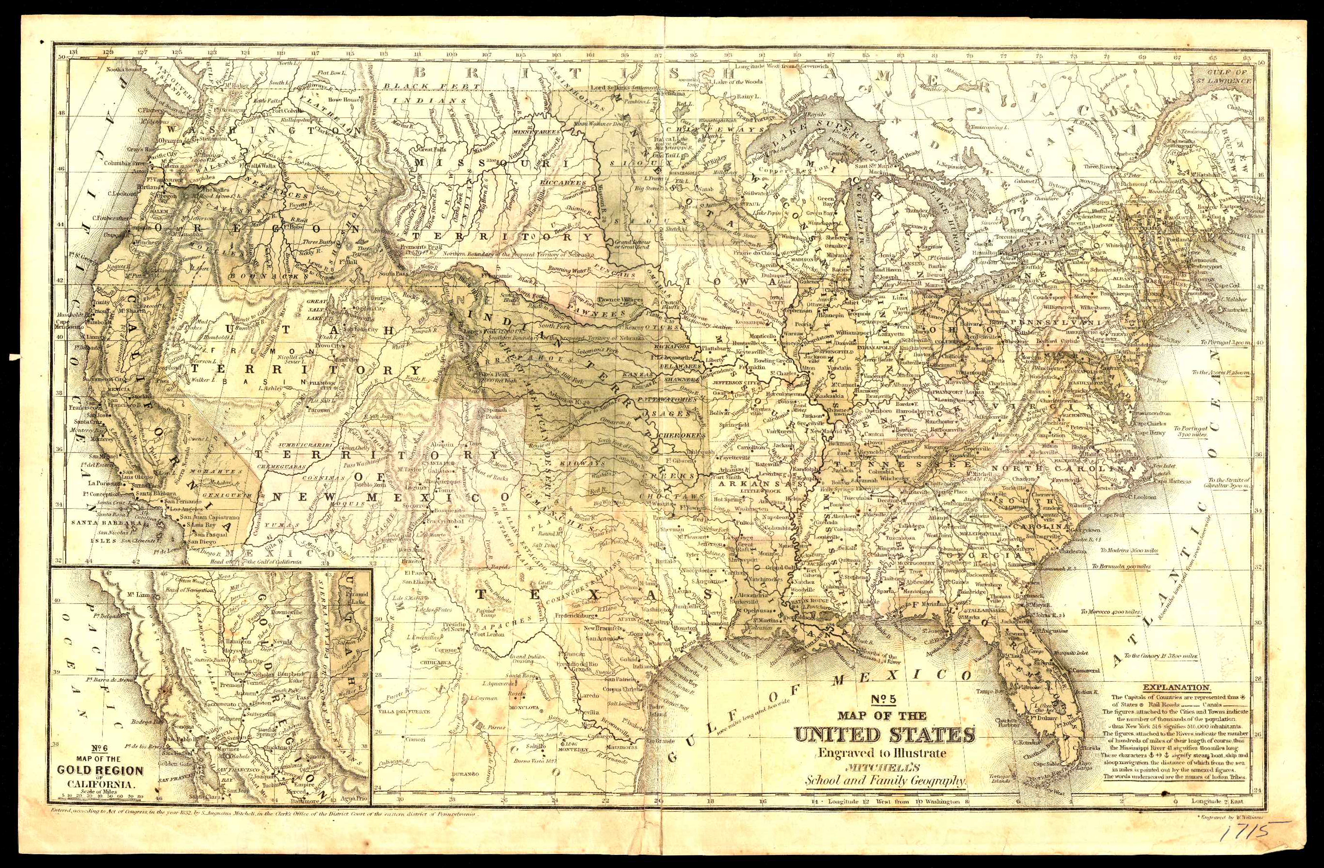
Collection: 973.64 W72m 1852 - Map of the United States : __engraved to illustrate Mitchell's school and family geography / __engraved by W. Williams
Folder:
Library
Item:
973.64 W72m 1852
Date:
Copyright 1852
Creator:
Williams, W. A.,--active 19th century
Title:
Map of the United States : __engraved to illustrate Mitchell's school and family geography / __engraved by W. Williams
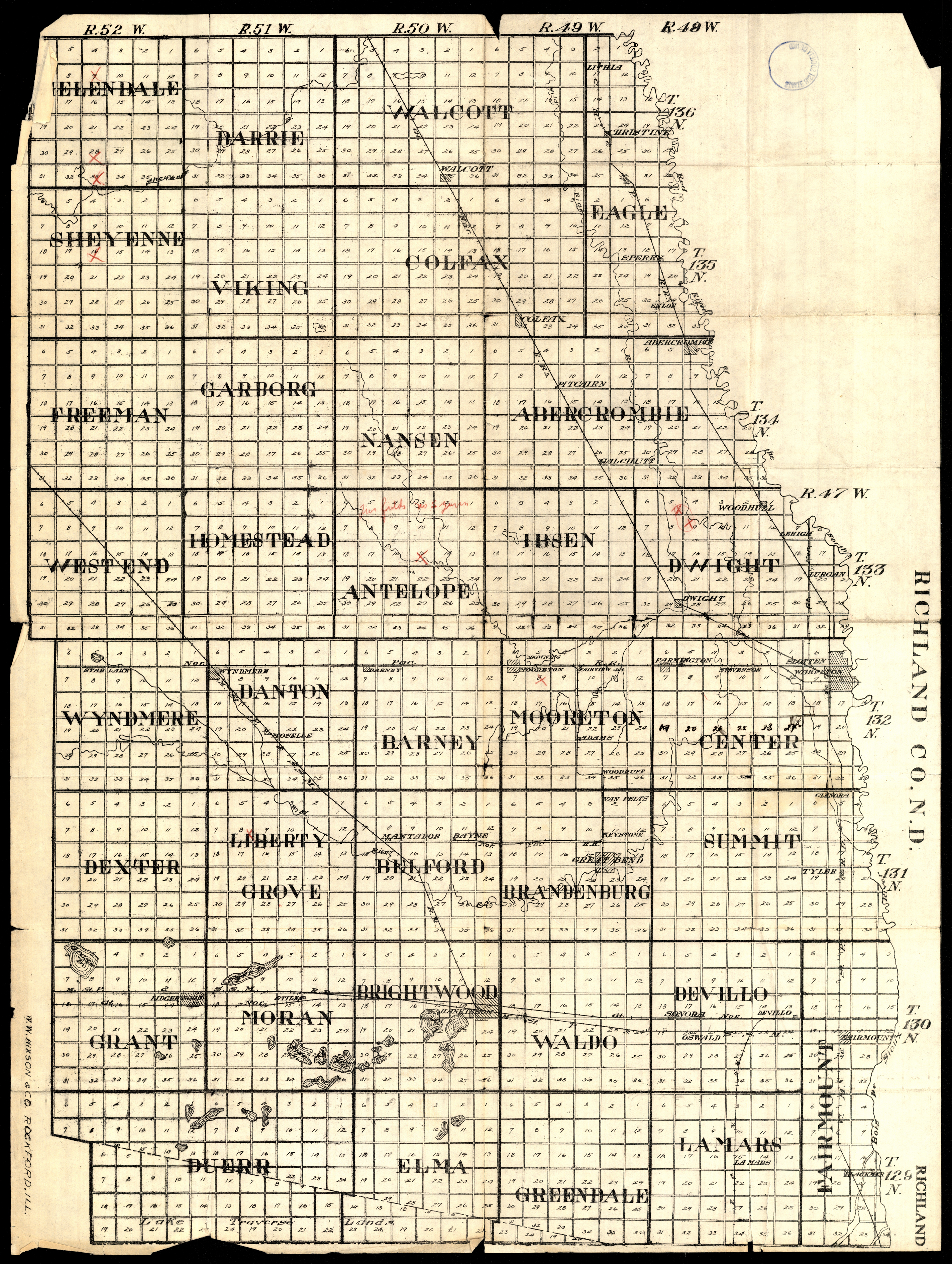
Collection: 978.412 W1117r 1916 - Richland Co., N.D
Folder:
Library
Item:
978.412 W1117r 1916
Date:
1916
Creator:
W.W. Hixson & Co
Title:
Richland Co., N.D