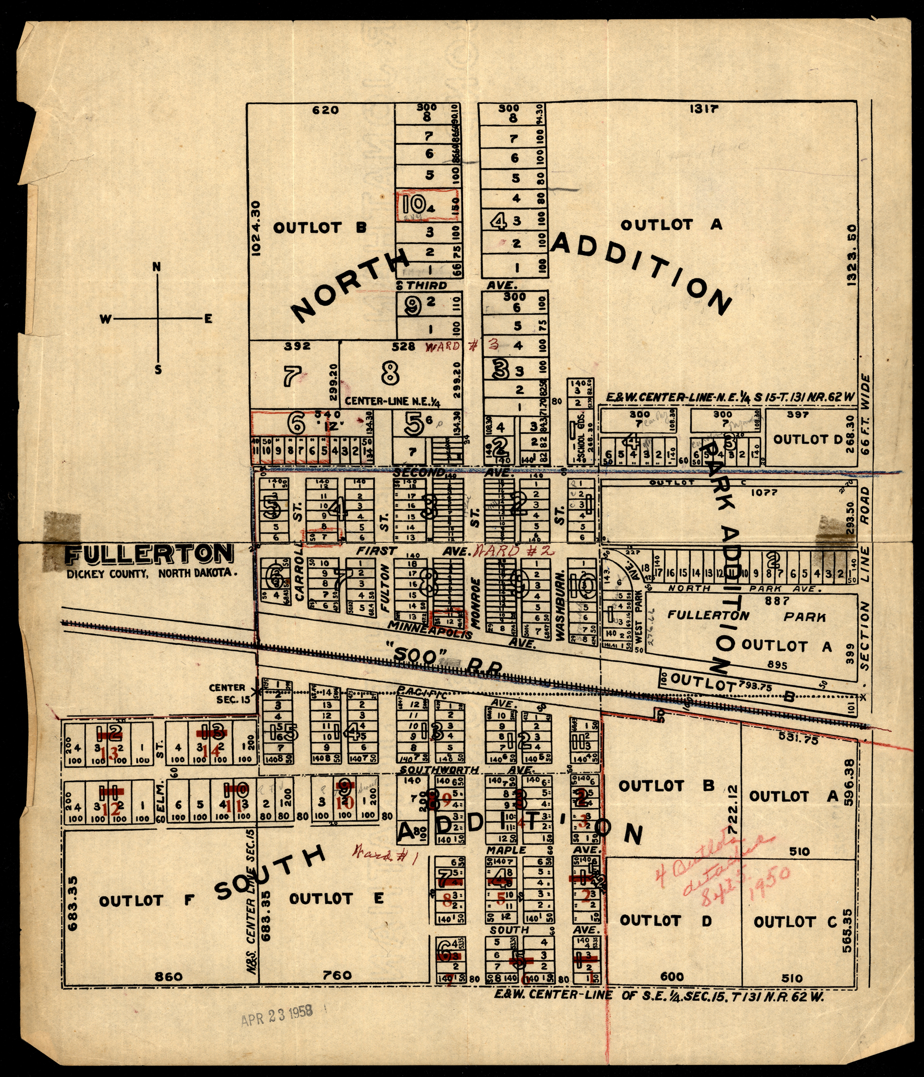
Collection: 978.454 F971 1958 - Fullerton, Dickey County, North Dakota
Folder:
Library
Item:
978.454 F971 1958
Date:
1958
Creator:
Title:
Fullerton, Dickey County, North Dakota
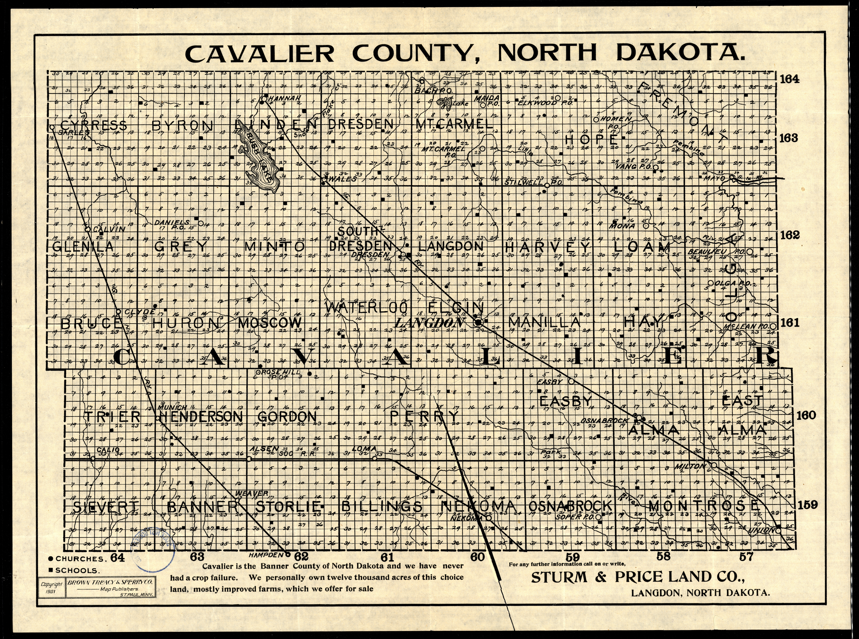
Collection: 978.437 B877c 1901 - Cavalier County, North Dakota / __ __Brown, Treacy & Sperry Co
Folder:
Library
Item:
978.437 B877c 1901
Date:
Copyright 1901
Creator:
Brown, Treacy & Sperry Co. (Saint Paul, Minn.)
Title:
Cavalier County, North Dakota / __ __Brown, Treacy & Sperry Co
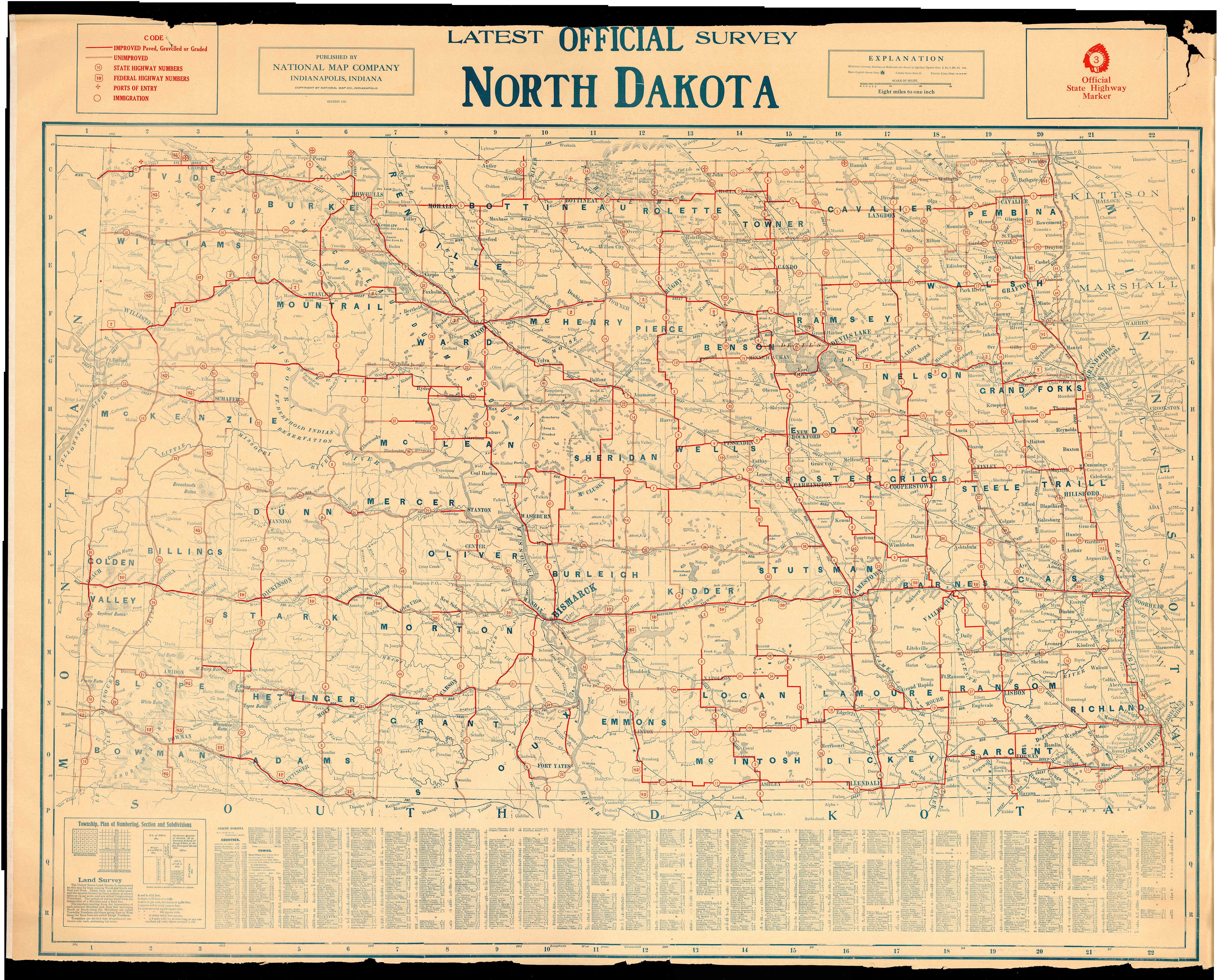
Collection: 978.4031 N277L - Latest official survey, North Dakota
Folder:
Library
Item:
978.4031 N277L
Date:
ca. 1915
Creator:
National Map Company
Title:
Latest official survey, North Dakota
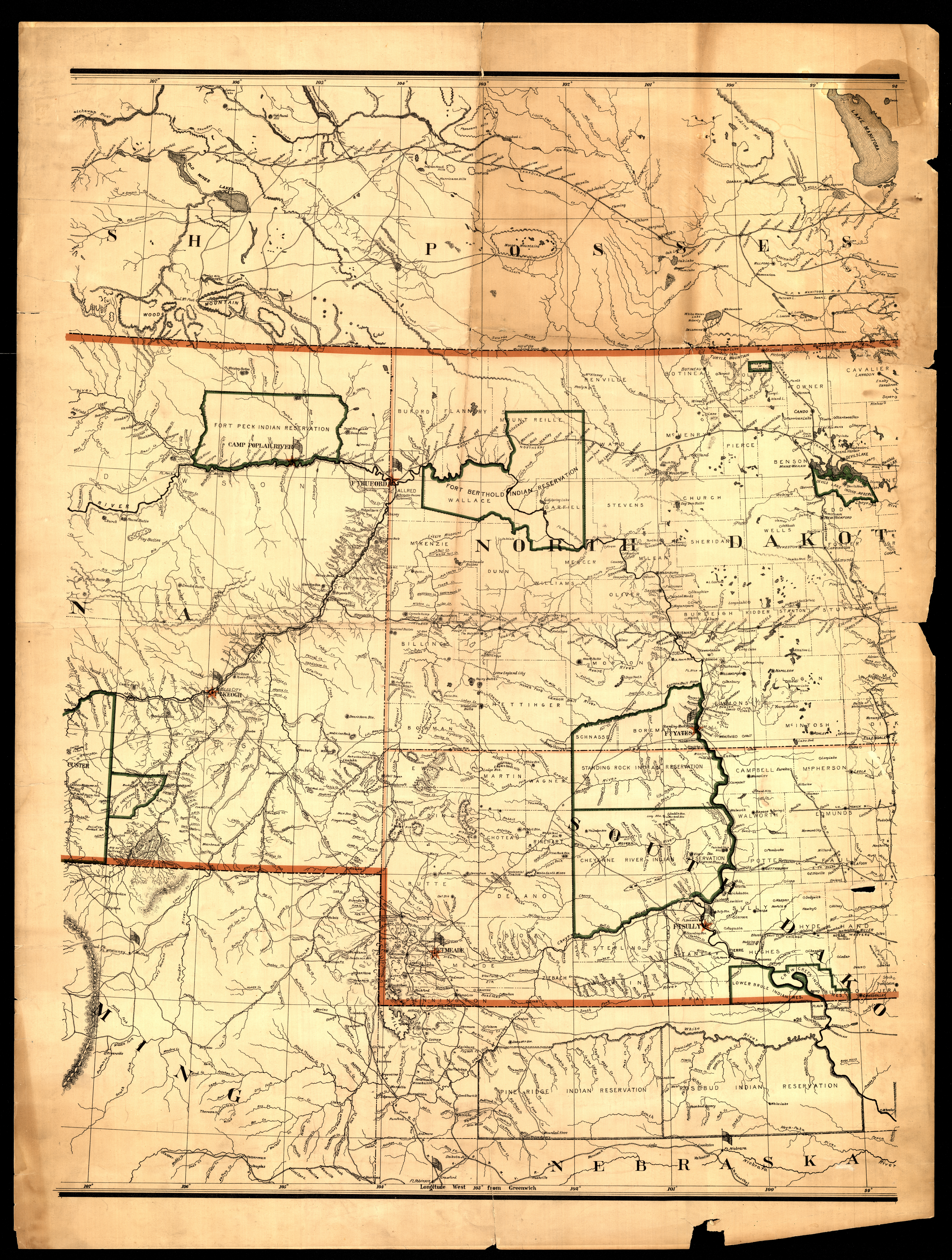
Collection: 978.02 R162m 1891 - Map of the Department of Dakota including Minnesota, North Dakota, Montana, Yellowstone National Park, and that portion of South Dakota lying north of the forty-fourth parallel of north latitude / __ __prepared by authority of Brigadier General Wesley Merritt in the Engineer Office Hdqrs. Dept. Dakota ; compiled and drawn under the direction of Lieut. Haydn S. Cole ... by H. F. Strebe
Folder:
Library
Item:
978.02 R162m 1891
Date:
1891
Creator:
United States.--Army.--Department of Dakota.--Engineer Office
Title:
Map of the Department of Dakota including Minnesota, North Dakota, Montana, Yellowstone National Park, and that portion of South Dakota lying north of the forty-fourth parallel of north latitude / __ __prepared by authority of Brigadier General Wesley Merritt in the Engineer Office Hdqrs. Dept. Dakota ; compiled and drawn under the direction of Lieut. Haydn S. Cole ... by H. F. Strebe
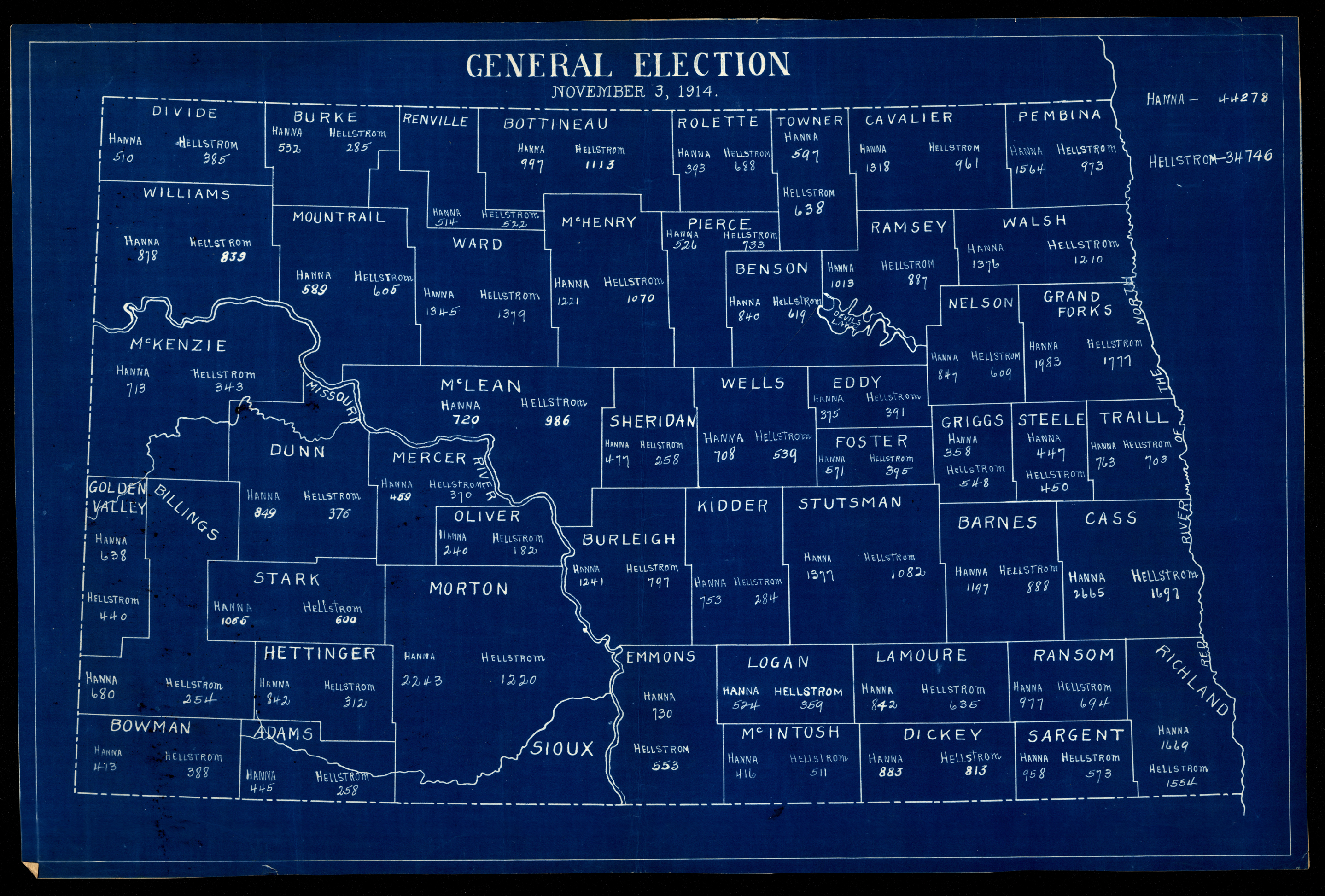
Collection: 324.9784 G3263 1914 - General election, November 3, 1914
Folder:
Library
Item:
324.9784 G3263 1914
Date:
1914
Creator:
Title:
General election, November 3, 1914
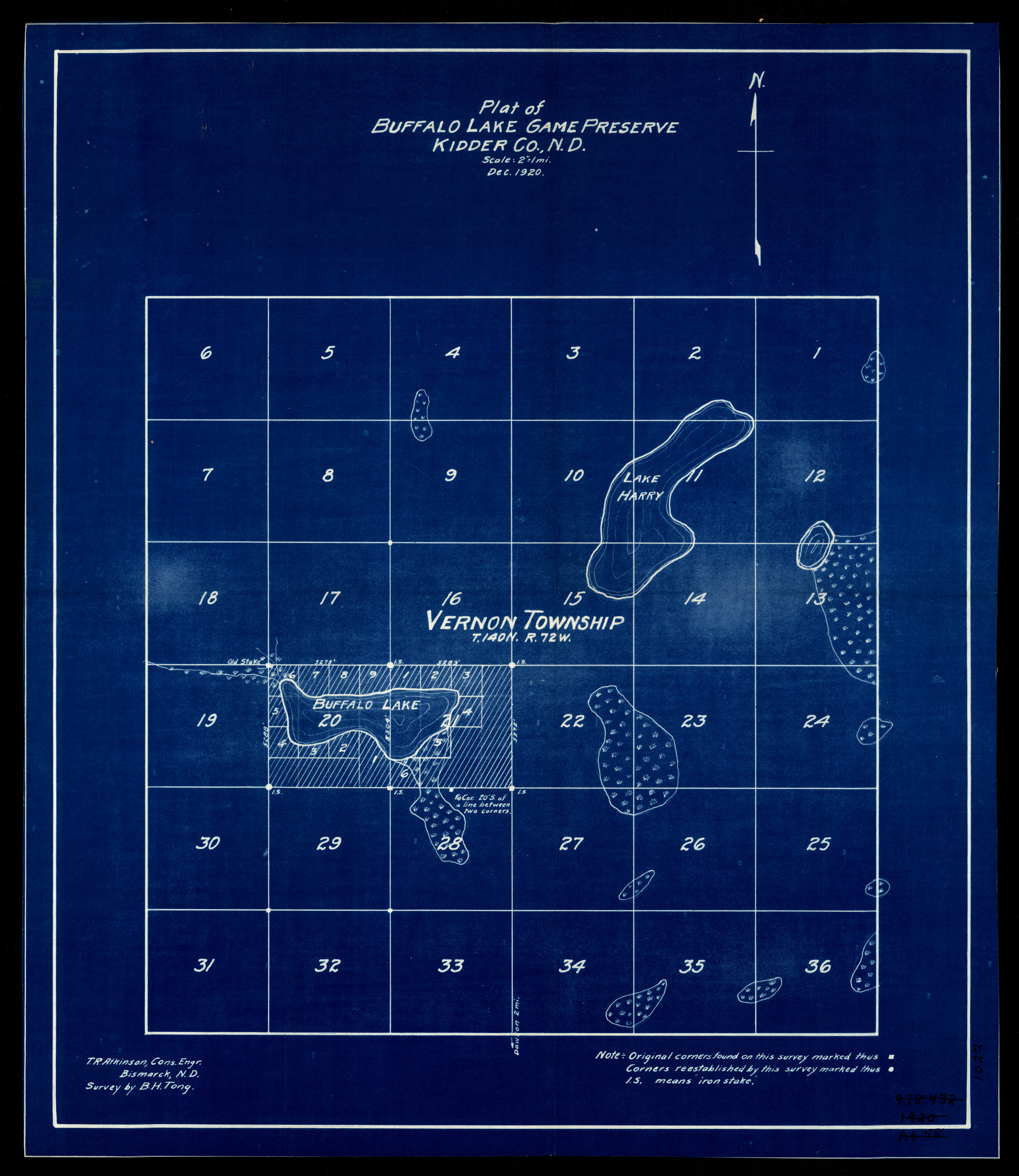
Collection: 978.457 A847pb 1920 - Plat of Buffalo Lake Game Preserve, Kidder Co., N.D. / __ __T.R. Atkinson cons. engr. ; survey by B.H. Tong
Folder:
Library
Item:
978.457 A847pb 1920
Date:
1920
Creator:
Atkinson, T. R
Title:
Plat of Buffalo Lake Game Preserve, Kidder Co., N.D. / __ __T.R. Atkinson cons. engr. ; survey by B.H. Tong
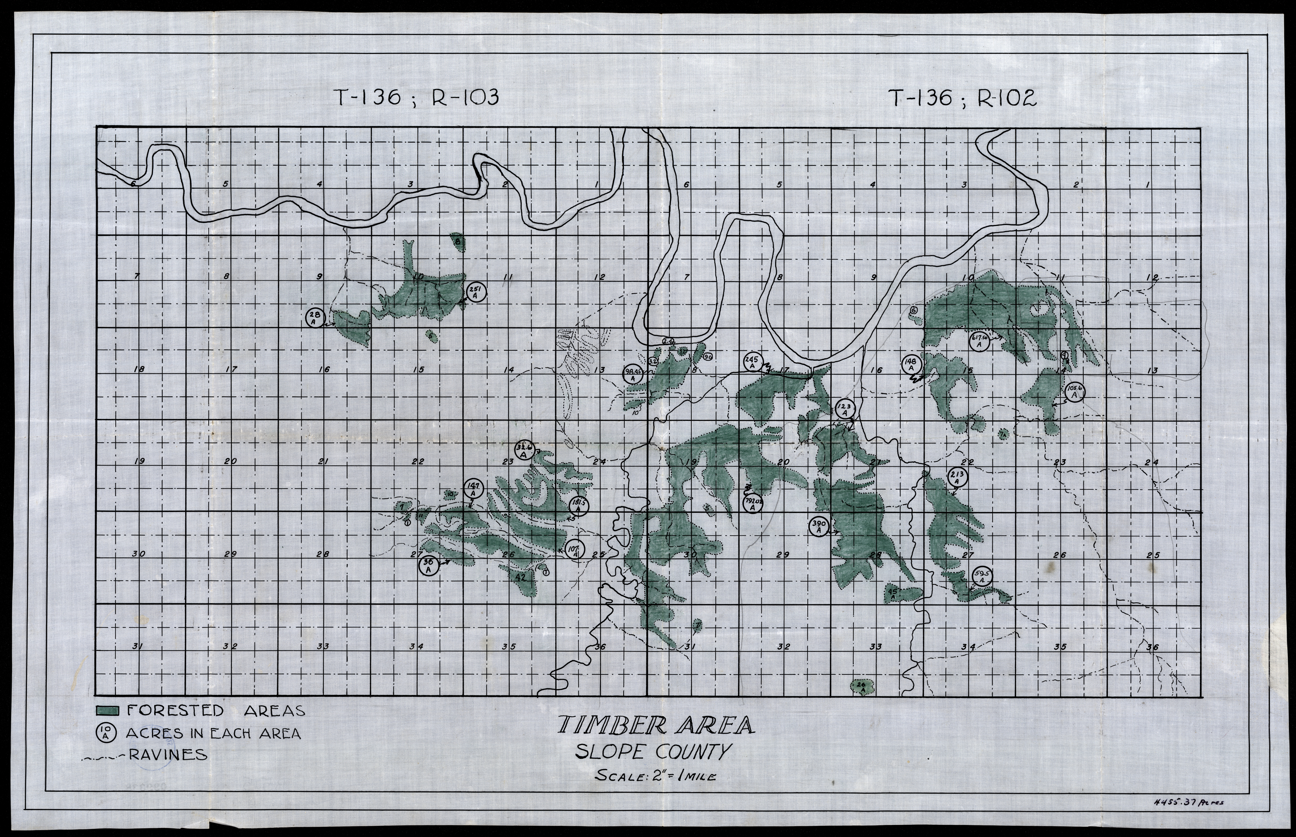
Collection: 978.493 T583 - Timber area, Slope County
Folder:
Library
Item:
978.493 T583
Date:
1900 - 1930
Creator:
Title:
Timber area, Slope County
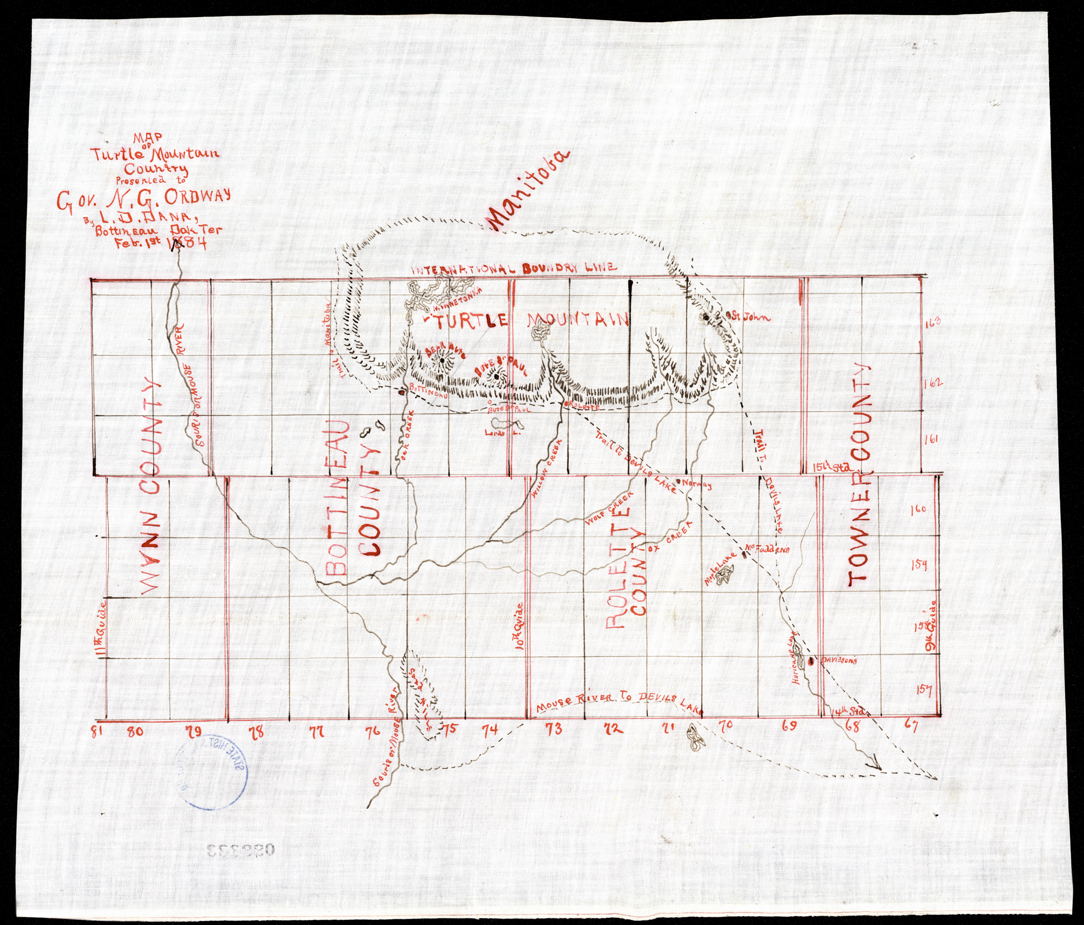
Collection: 978.46 D167m 1884 - Map of Turtle Mountain country / __ __presented to Gov. N.G. Ordway by L.D. Dana
Folder:
Library
Item:
978.46 D167m 1884
Date:
1884
Creator:
Dana, L. D
Title:
Map of Turtle Mountain country / __ __presented to Gov. N.G. Ordway by L.D. Dana
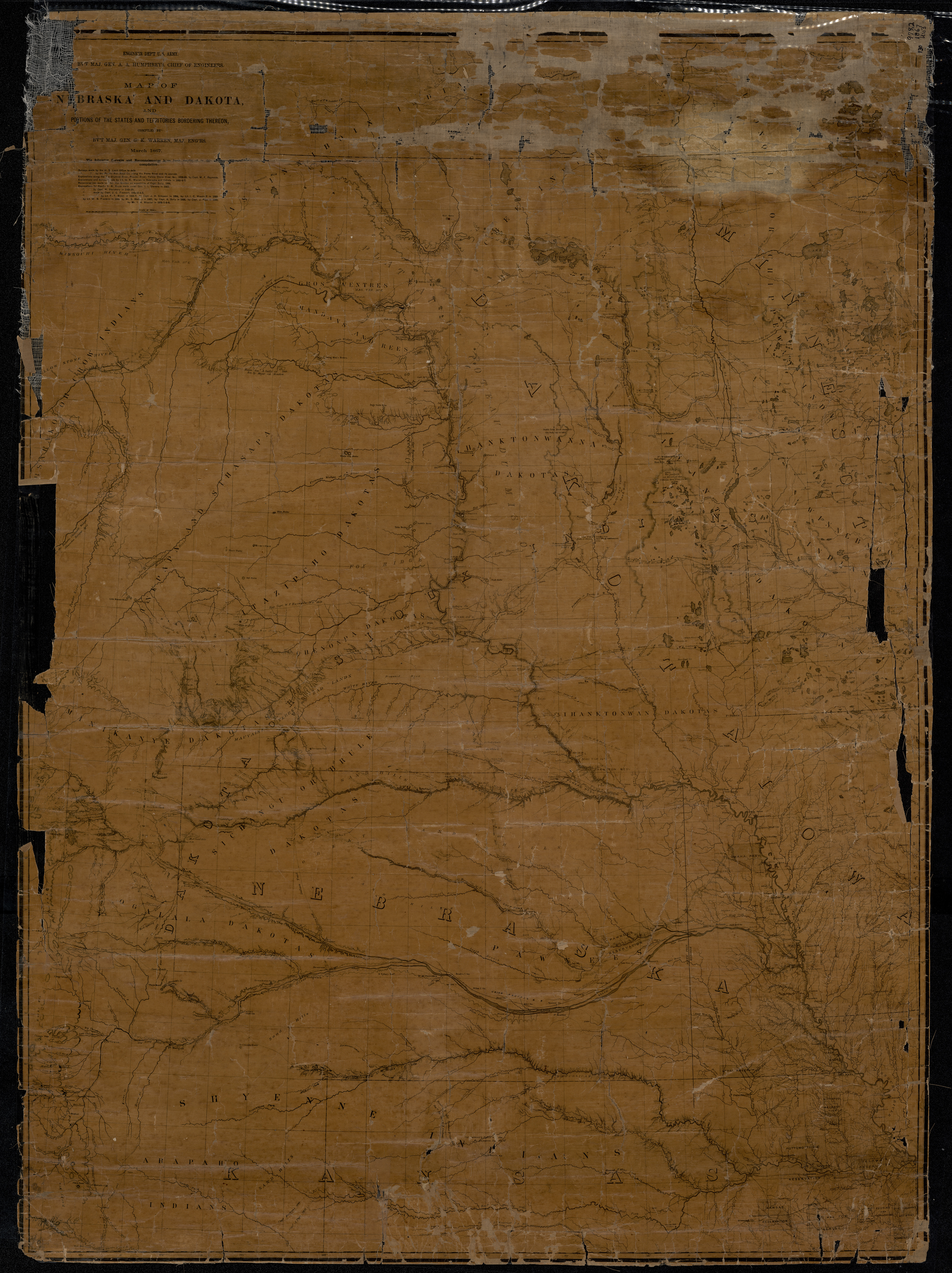
Collection: 978.02 W286m 1867 - Map of Nebraska and Dakota and portions of the states and territories bordering thereon / __ __compiled by Bv't Maj. Gen. G.K. Warren, Maj. Engineers, March, 1867
Folder:
Library
Item:
978.02 W286m 1867
Date:
1867
Creator:
Warren, G. K.--(Gouverneur Kemble),--1830-1882
Title:
Map of Nebraska and Dakota and portions of the states and territories bordering thereon / __ __compiled by Bv't Maj. Gen. G.K. Warren, Maj. Engineers, March, 1867
Collection: 978.403 C889n 1892 - North Dakota
Folder:
Library
Item:
978.403 C889n 1892
Date:
1892
Creator:
Cram, George Franklin,--1841-1928
Title:
North Dakota
Collection: 978.02 G3452p 1877 - Progress map of the U.S. Geographical Surveys west of the 100th meridian. __to accompany the annual report of 1st lieut. George M. Wheeler / __1st lieut. Geo. M. Wheeler, Corps of Engineers, U.S. Army, in charge ; under the direction of Brig. Gen. A.A. Humphreys, chief of engineers, U.S. Army
Folder:
Library
Item:
978.02 G3452p 1877
Date:
1877
Creator:
Geographical Surveys West of the 100th Meridian (U.S.)
Title:
Progress map of the U.S. Geographical Surveys west of the 100th meridian. __to accompany the annual report of 1st lieut. George M. Wheeler / __1st lieut. Geo. M. Wheeler, Corps of Engineers, U.S. Army, in charge ; under the direction of Brig. Gen. A.A. Humphreys, chief of engineers, U.S. Army
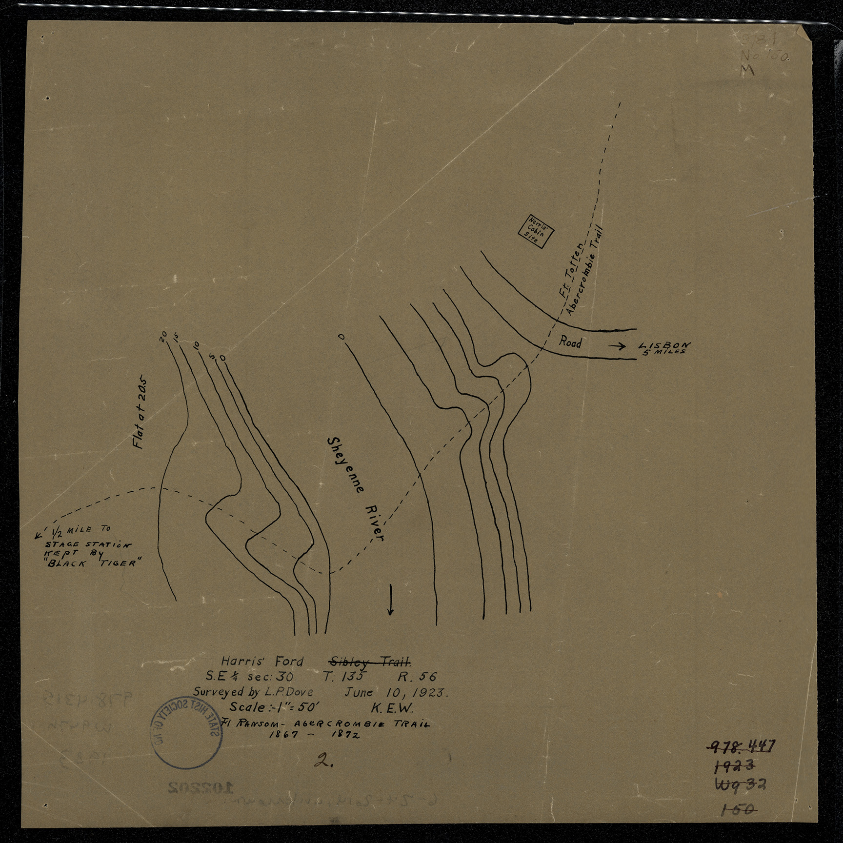
Collection: 978.4315 W947h 1923 - Harris' ford / __ __surveyed by L.P. Dove ; [map drawn by K.E. Wright]
Folder:
Library
Item:
978.4315 W947h 1923
Date:
1923
Creator:
Wright, K. E
Title:
Harris' ford / __ __surveyed by L.P. Dove ; [map drawn by K.E. Wright]
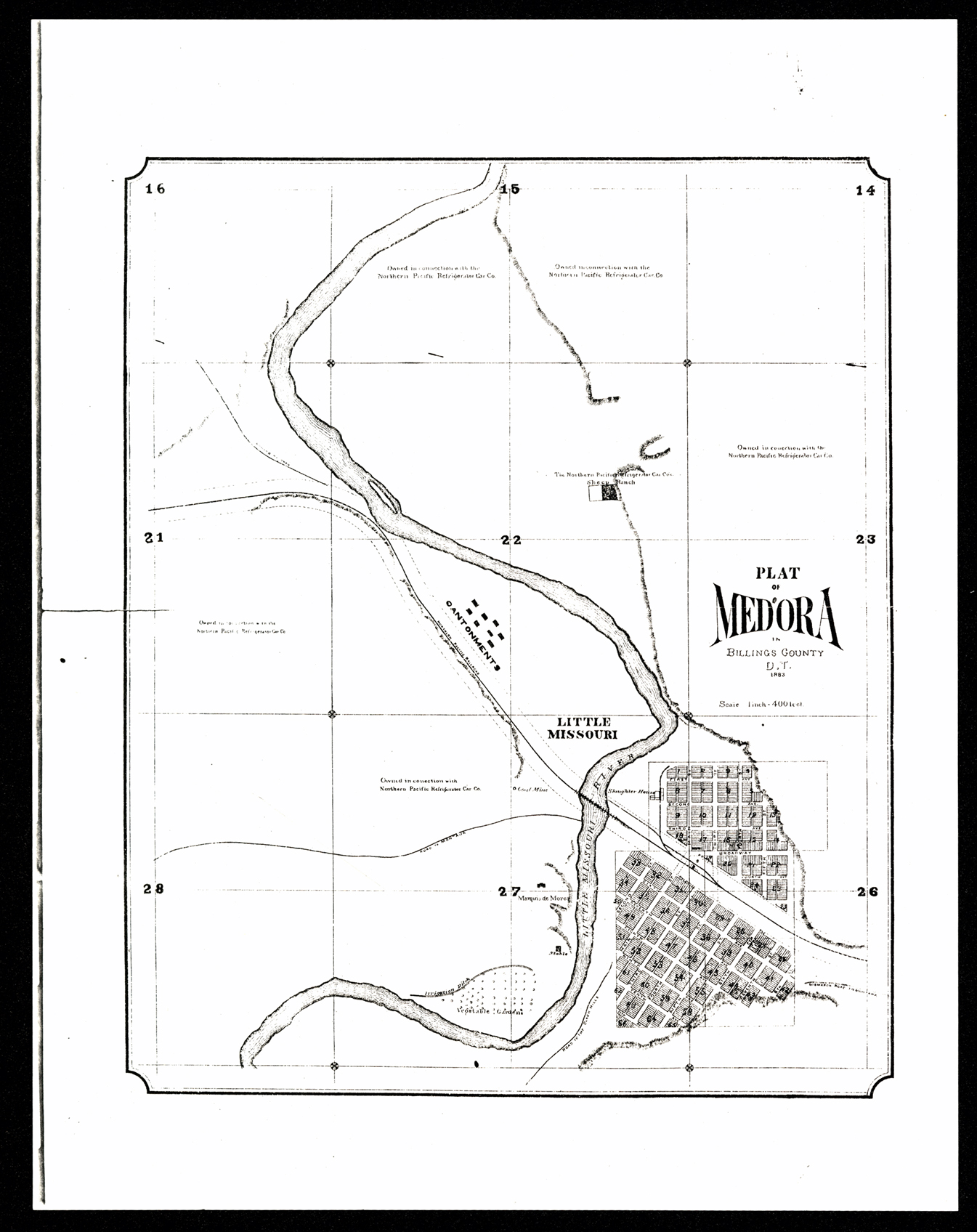
Collection: 978.494 P716 1883 - Plat of Medora in Billings County, D.T
Folder:
Library
Item:
978.494 P716 1883
Date:
1883
Creator:
Title:
Plat of Medora in Billings County, D.T
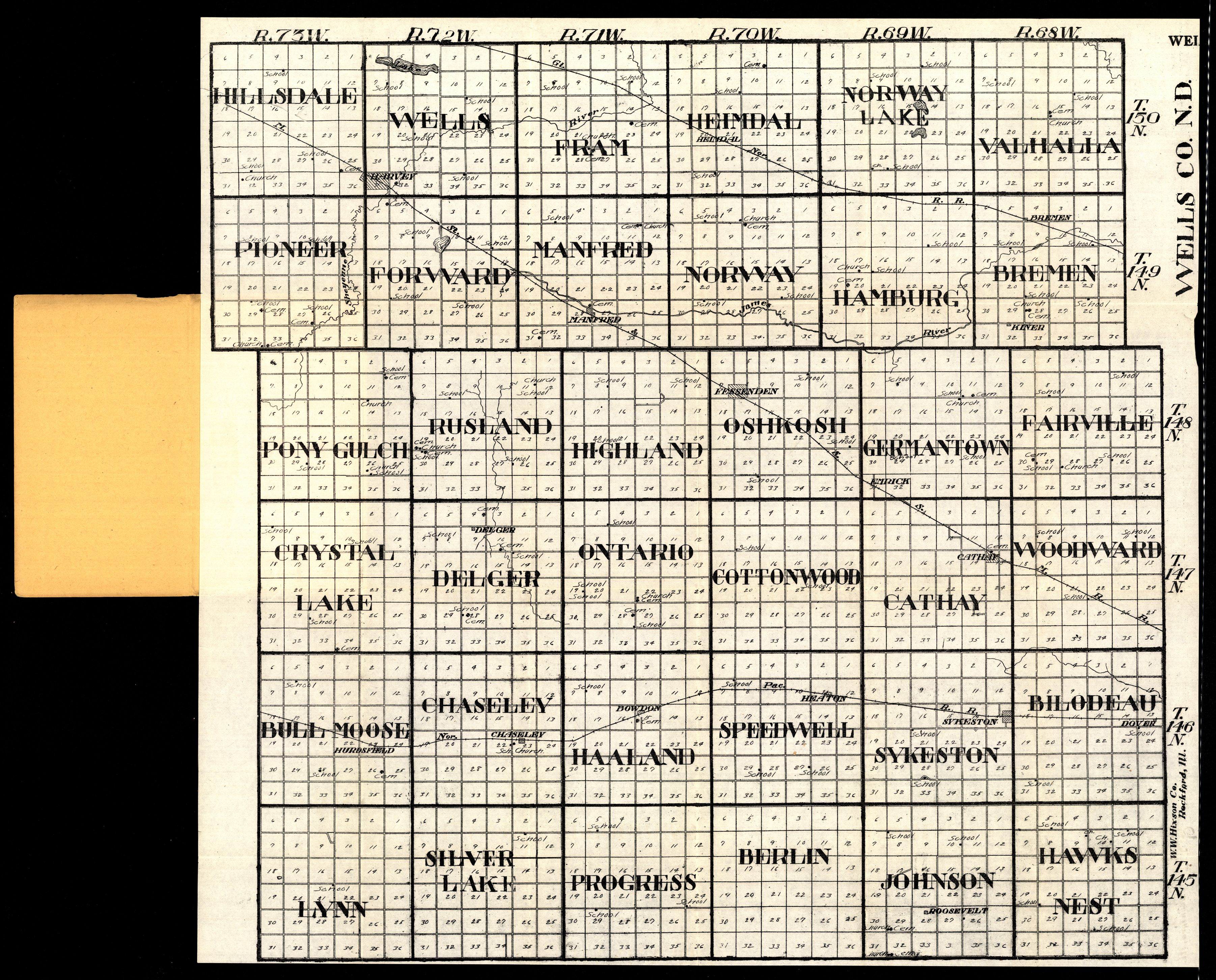
Collection: 978.458 W1117w 1916 - Wells Co., N.D
Folder:
Library
Item:
978.458 W1117w 1916
Date:
1916
Creator:
W.W. Hixson & Co
Title:
Wells Co., N.D
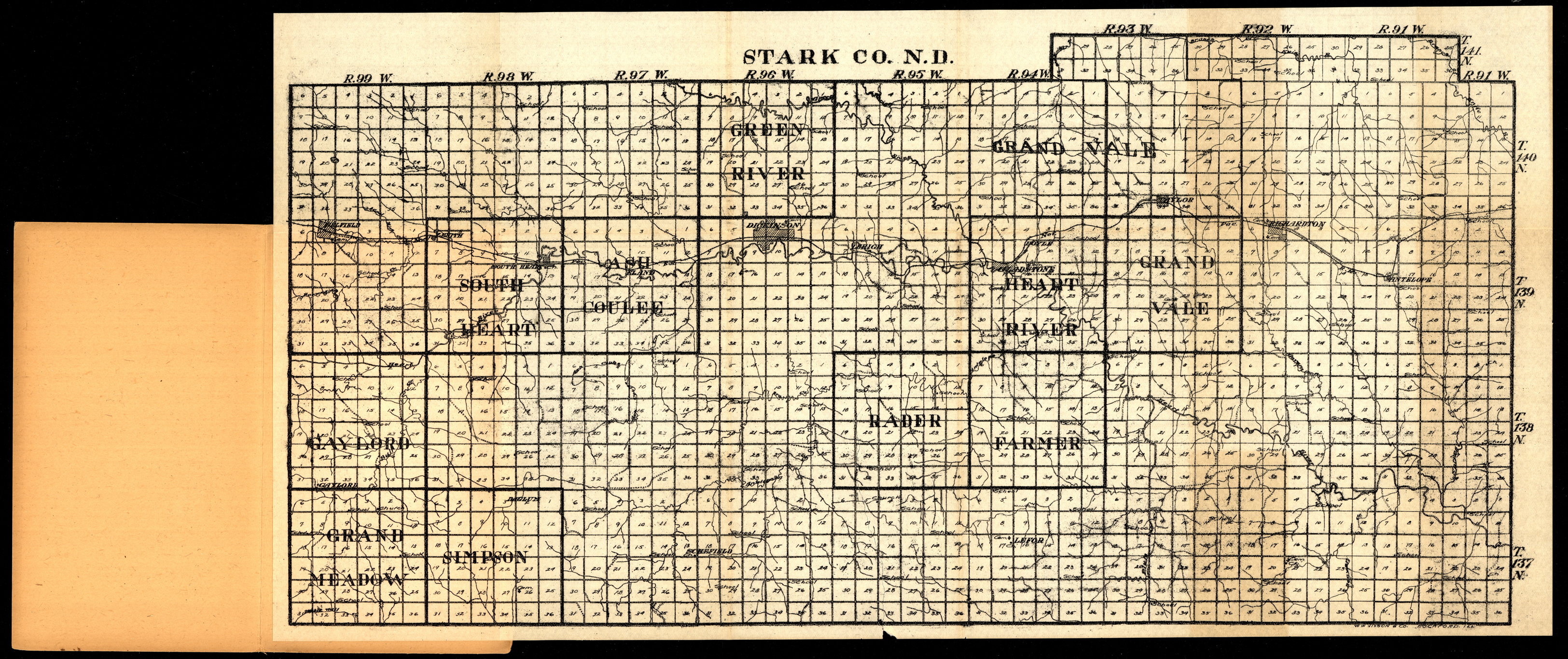
Collection: 978.4844 W1117s 1916 - Stark Co., N.D
Folder:
Library
Item:
978.4844 W1117s 1916
Date:
1916
Creator:
W.W. Hixson & Co
Title:
Stark Co., N.D
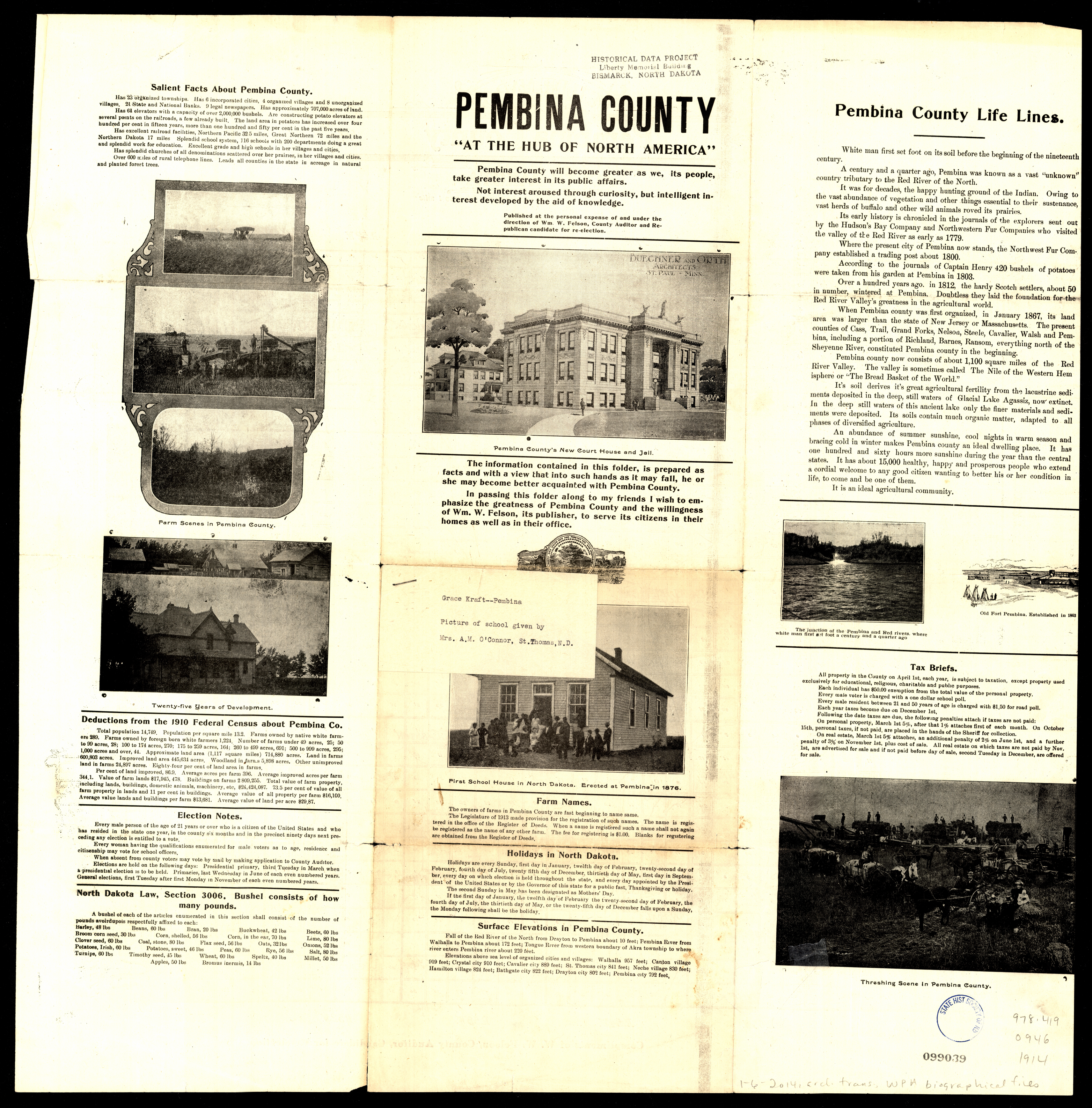
Collection: 978.419 O946 1914 - Outline map of Pembina County, North Dakota
Folder:
Library
Item:
978.419 O946 1914
Date:
1914
Creator:
Title:
Outline map of Pembina County, North Dakota
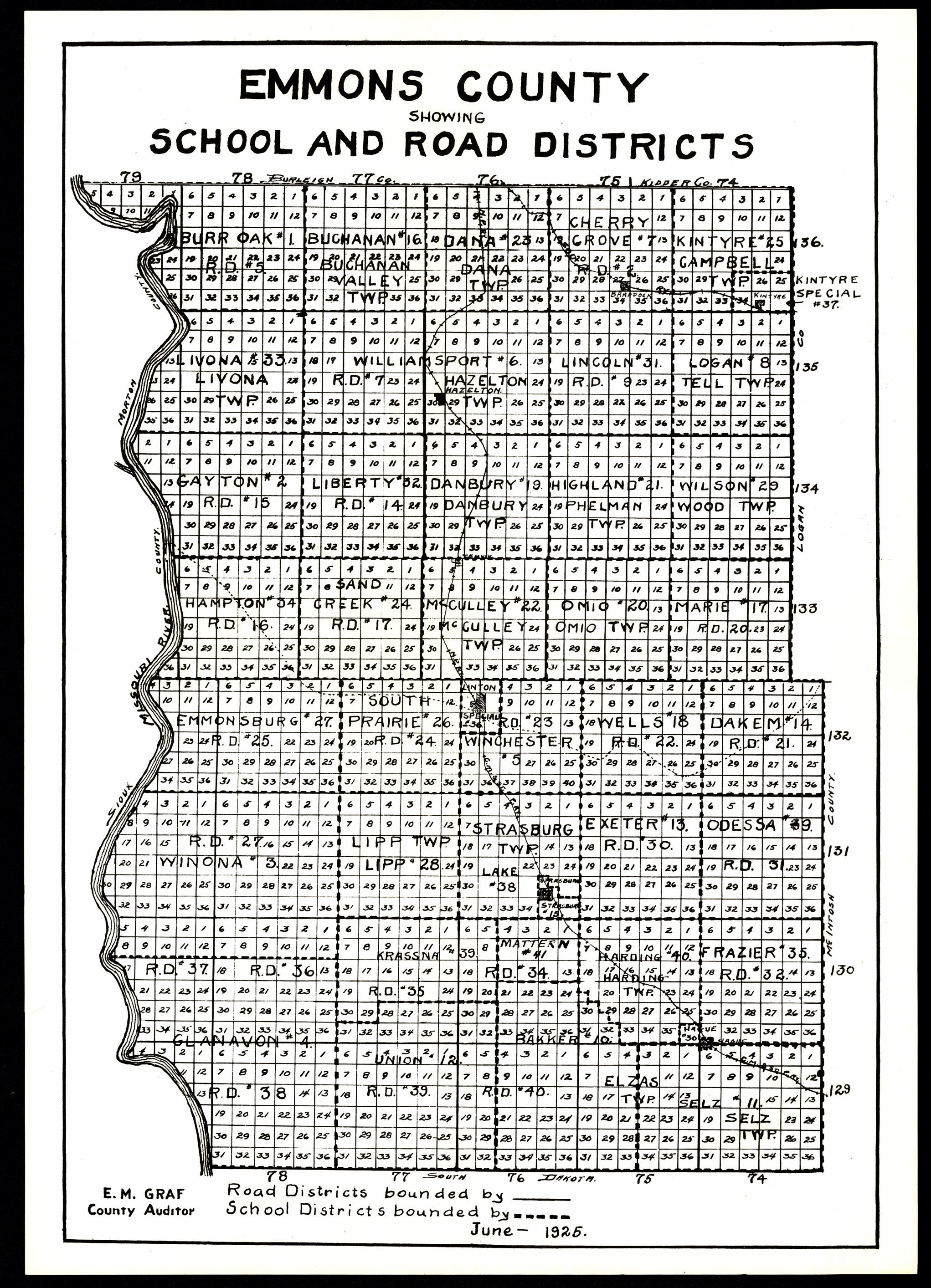
Collection: 978.478 E546 1925 - Emmons County, showing school and road districts / __ __E.M. Graf, county auditor
Folder:
Library
Item:
978.478 E546 1925
Date:
1925
Creator:
Title:
Emmons County, showing school and road districts / __ __E.M. Graf, county auditor
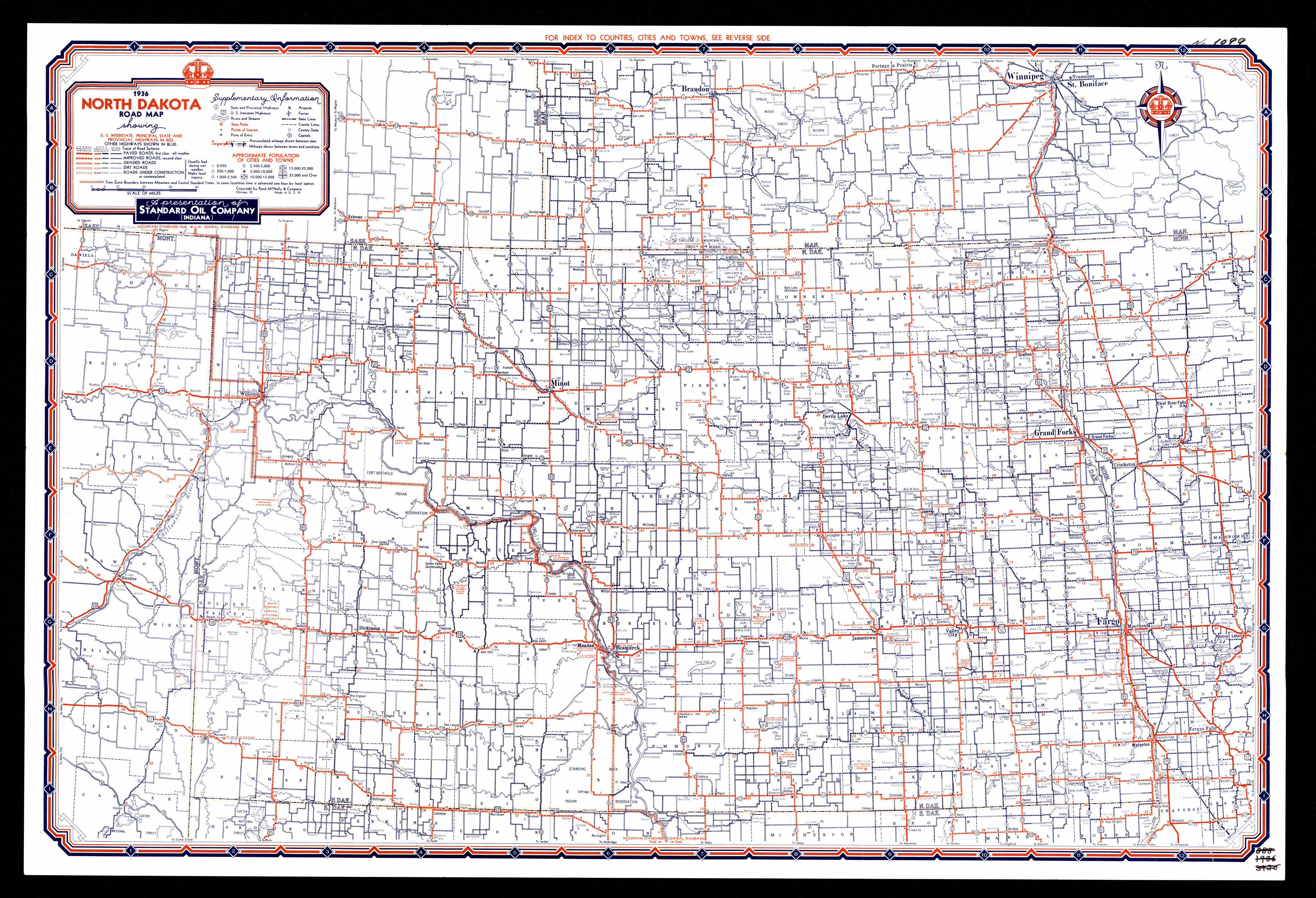
Collection: 978.4032 R186r 1936 - Road map, North Dakota / __ __a presentation of Standard Oil Company (Indiana)
Folder:
Library
Item:
978.4032 R186r 1936
Date:
1936
Creator:
Rand McNally and Company
Title:
Road map, North Dakota / __ __a presentation of Standard Oil Company (Indiana)
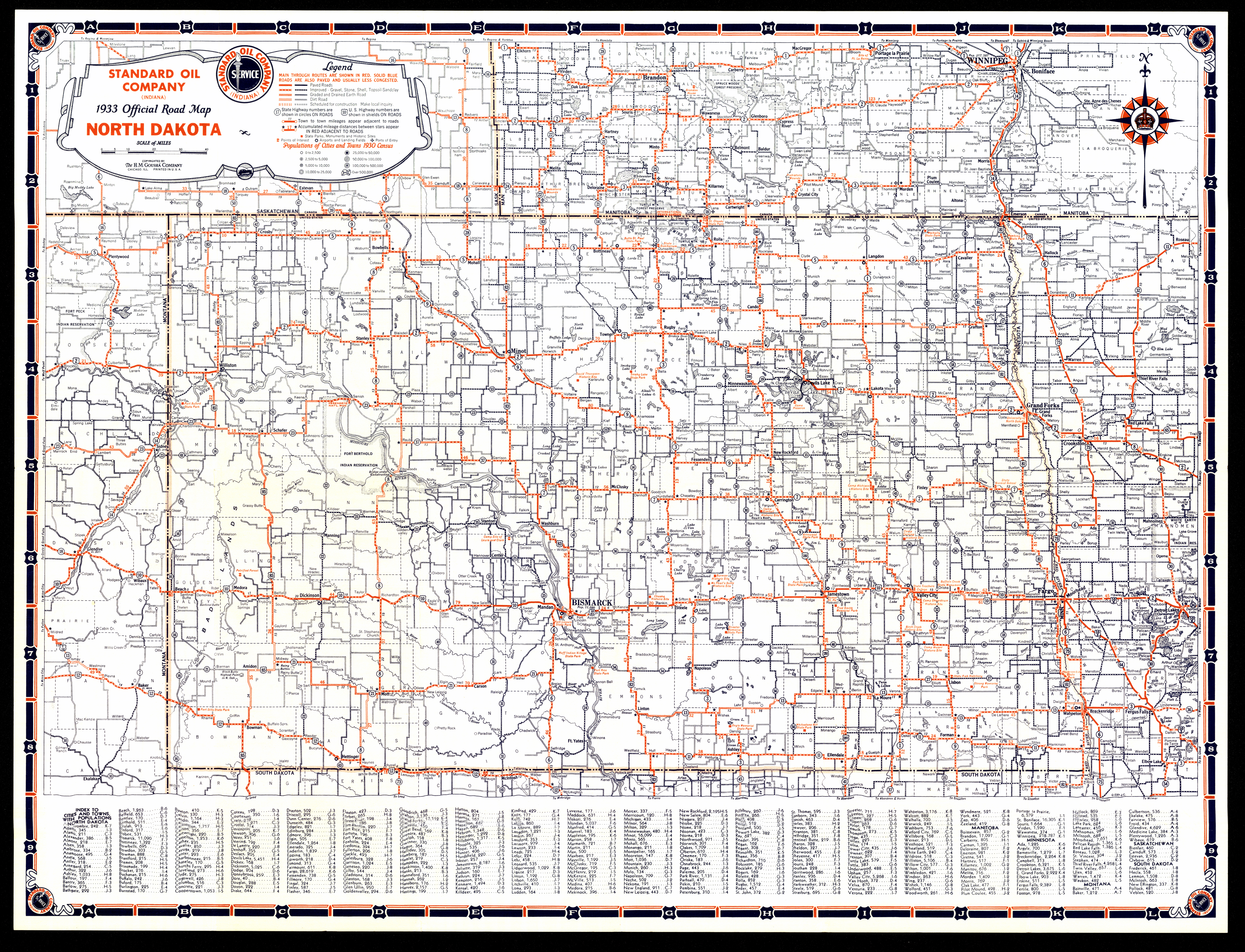
Collection: 978.4032 G717o 1933 - 1933 official road map, North Dakota / __ __H.M. Goushá Company [for] Standard Oil Company
Folder:
Library
Item:
978.4032 G717o 1933
Date:
1933
Creator:
H.M. Gousha Company
Title:
1933 official road map, North Dakota / __ __H.M. Goushá Company [for] Standard Oil Company
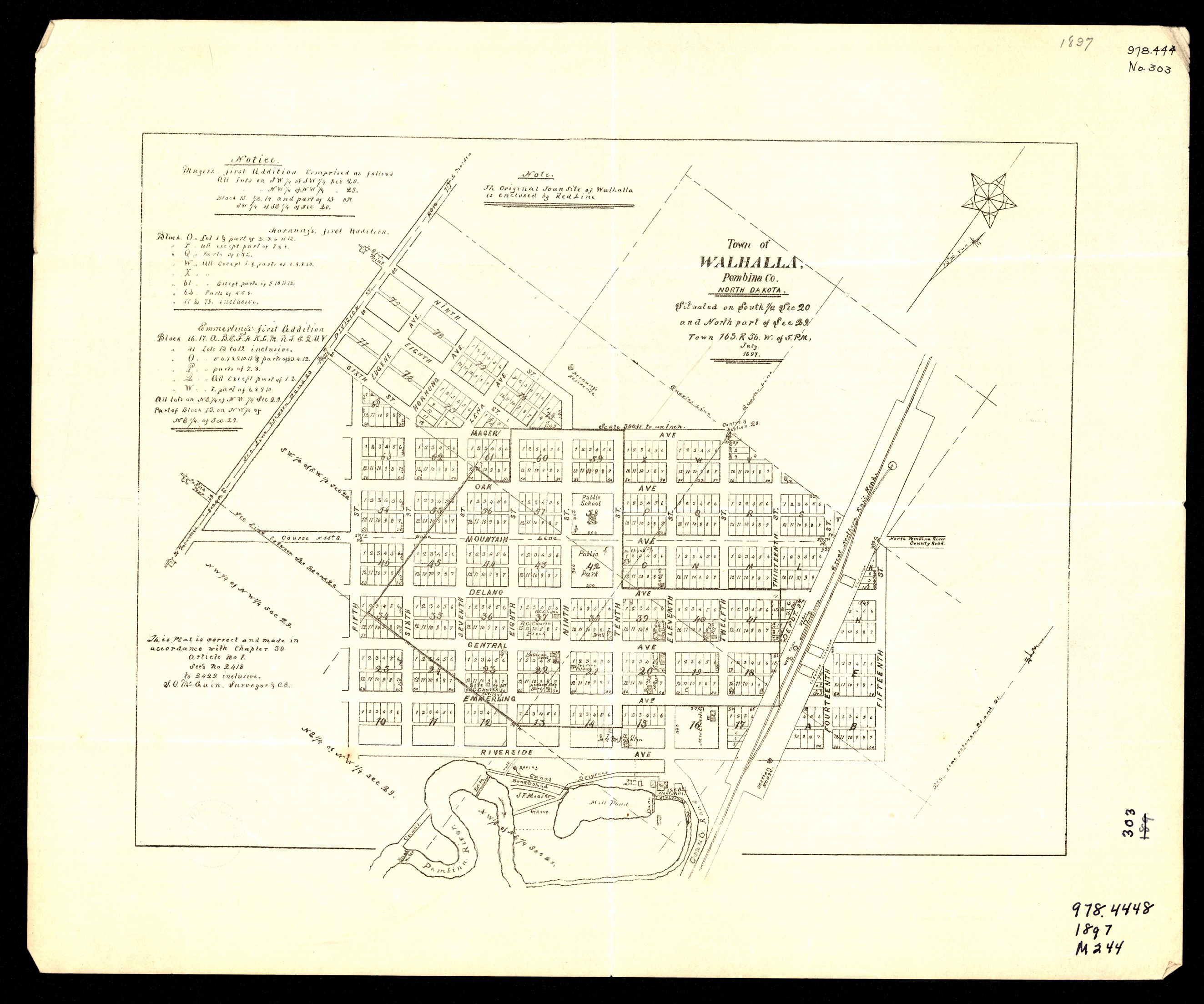
Collection: 978.419 W149 1897 - Town of Walhalla, Pembina Co., North Dakota
Folder:
Library
Item:
978.419 W149 1897
Date:
1897
Creator:
Title:
Town of Walhalla, Pembina Co., North Dakota
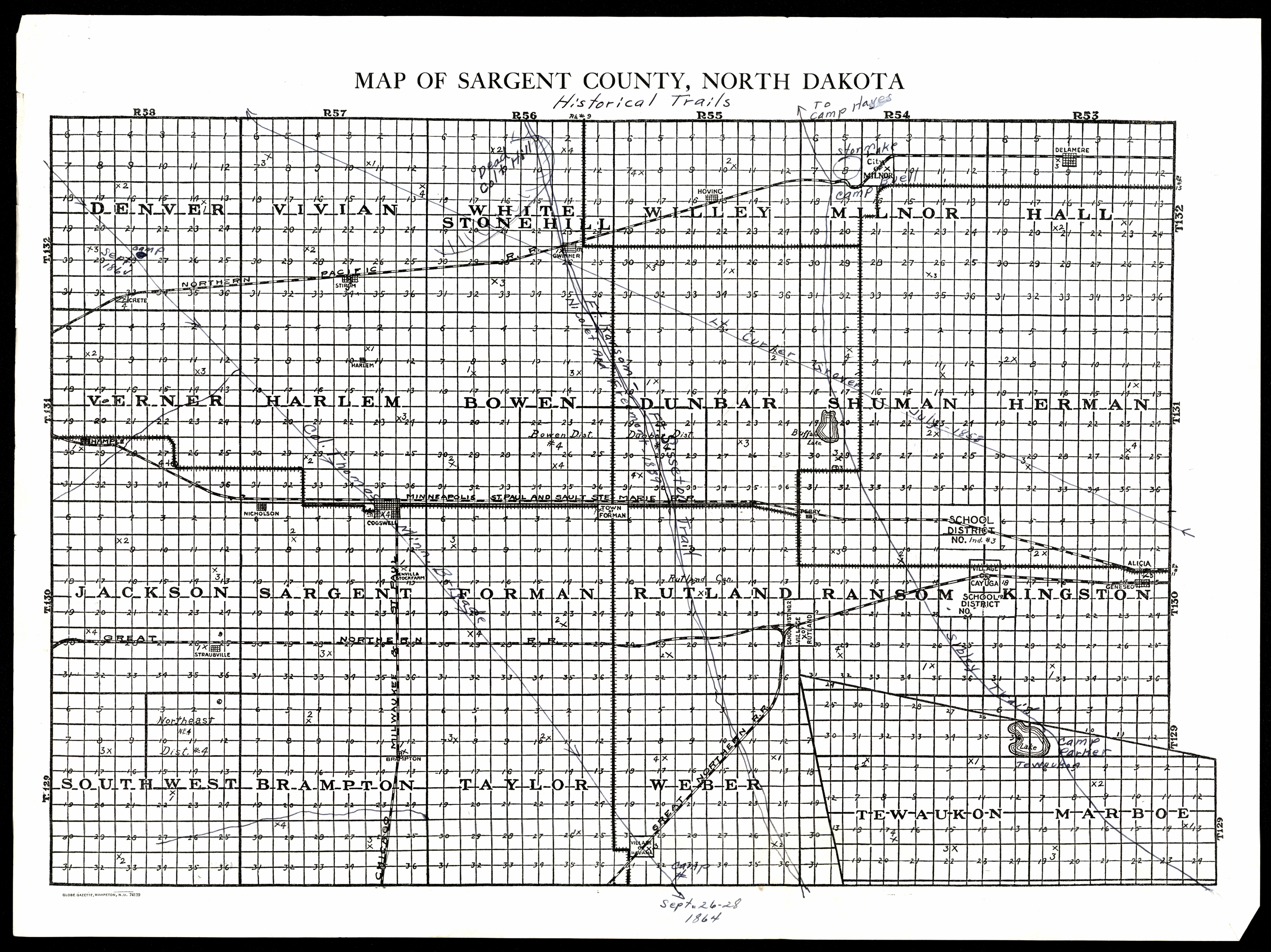
Collection: 978.4314 M297h - Map of Sargent County, North Dakota : __historical trails
Folder:
Library
Item:
978.4314 M297h
Date:
ca. 1925
Creator:
Title:
Map of Sargent County, North Dakota : __historical trails
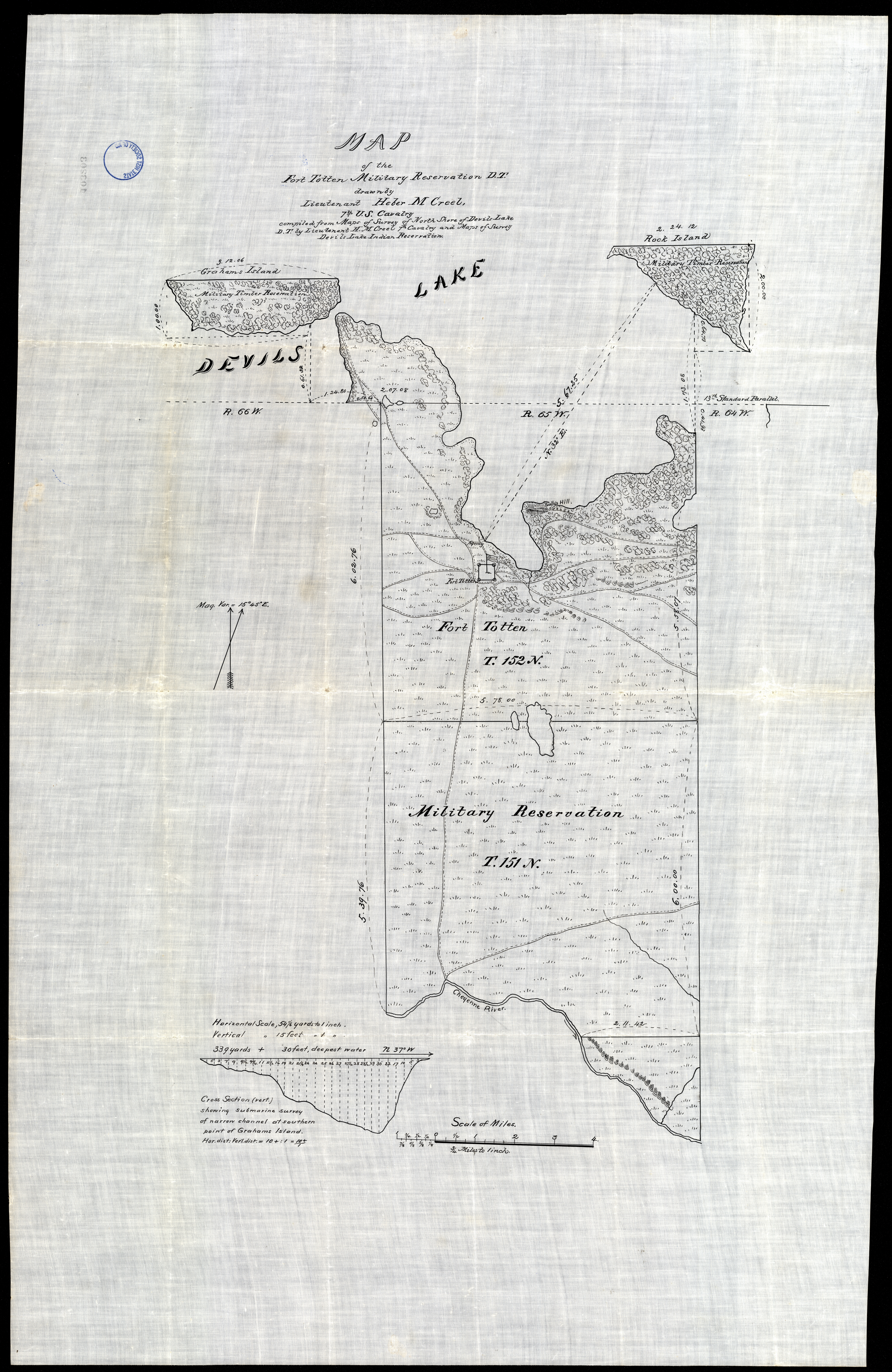
Collection: 978.439 C9135mf - Map of the Fort Totten Military Reservation, D.T. / __ __drawn by Lieutenant Heber M. Creel, 7th U.S. Cavalry, compiled from maps of survey of north shore of Devils Lake D.T. by Lieutenant H.M. Creel 7th Cavalry and maps of survey, Devils Lake Indian Reservation
Folder:
Library
Item:
978.439 C9135mf
Date:
ca. 1885
Creator:
Creel, Heber M
Title:
Map of the Fort Totten Military Reservation, D.T. / __ __drawn by Lieutenant Heber M. Creel, 7th U.S. Cavalry, compiled from maps of survey of north shore of Devils Lake D.T. by Lieutenant H.M. Creel 7th Cavalry and maps of survey, Devils Lake Indian Reservation
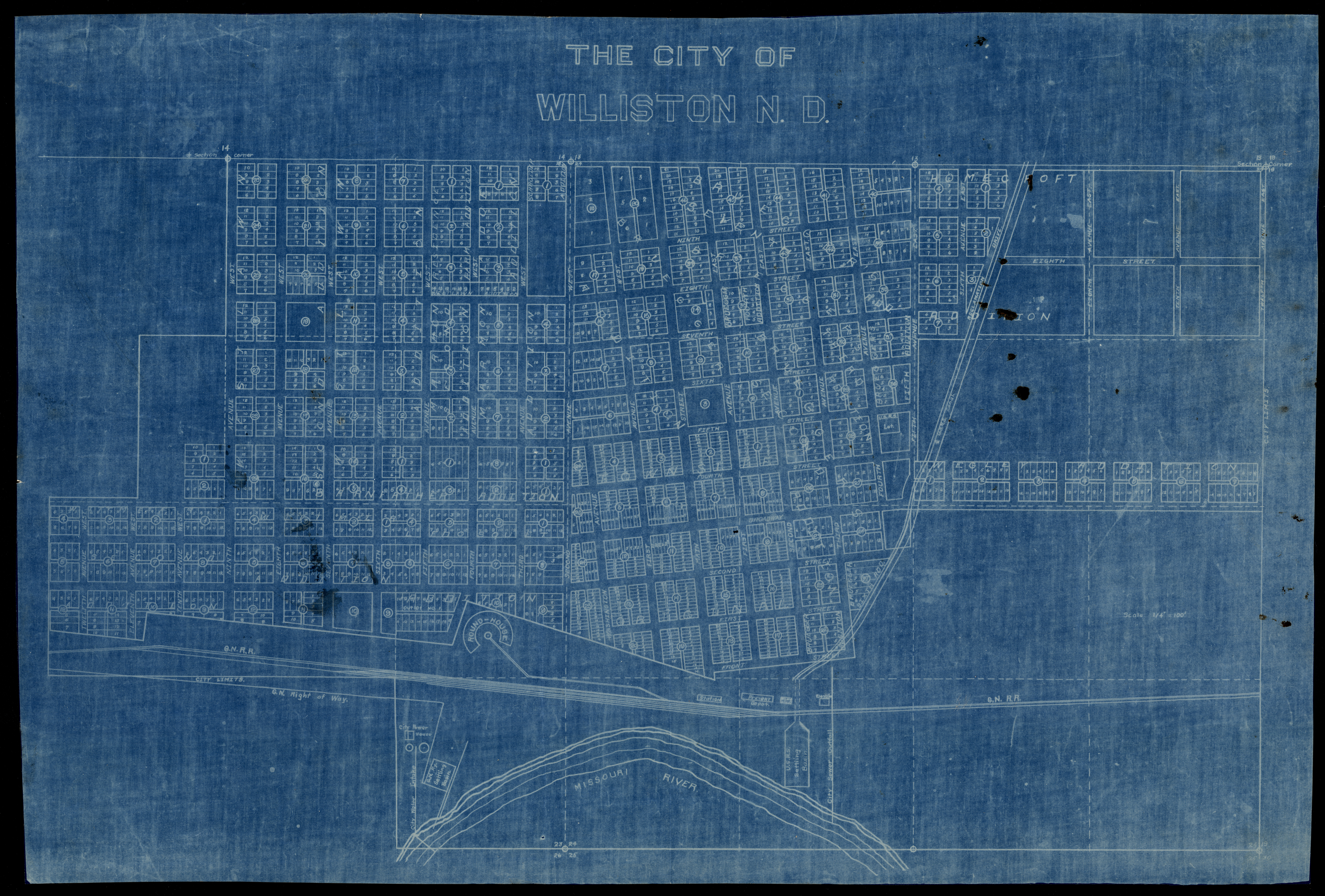
Collection: 978.473 C5814 - The city of Williston, N.D
Folder:
Library
Item:
978.473 C5814
Date:
1900 - 1910
Creator:
Title:
The city of Williston, N.D
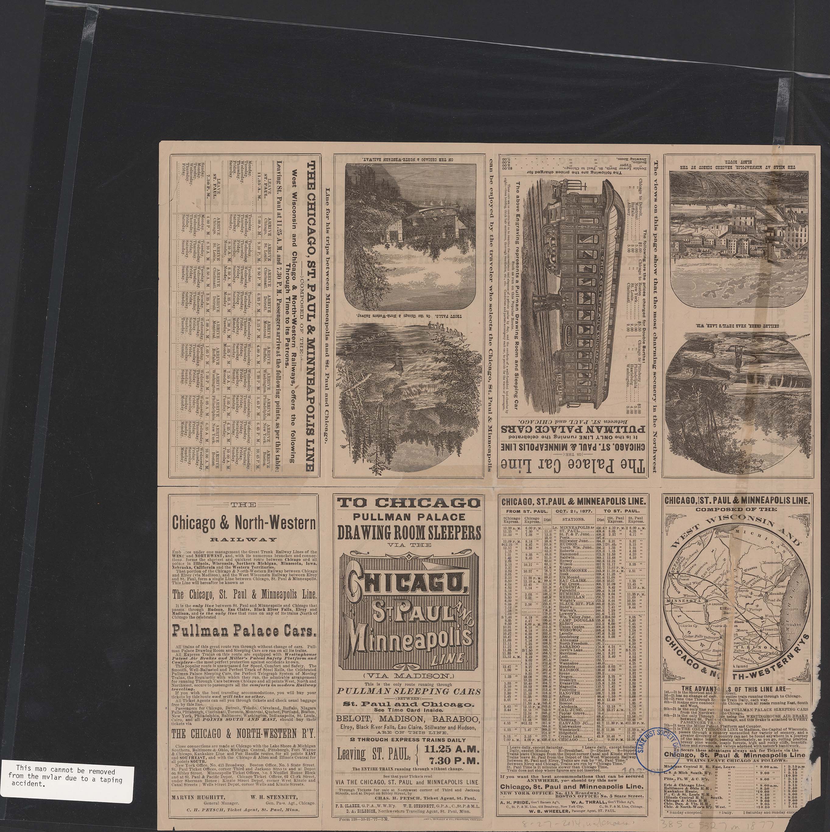
Collection: 385 C5327m 1877 - Map showing the Chicago, St. Paul & Minneapolis Line, via Madison, and its connections in the Northwest, the Northern Pacific Railway and Manitoba
Folder:
Library
Item:
385 C5327m 1877
Date:
1877
Creator:
Chicago and North Western Railway Company
Title:
Map showing the Chicago, St. Paul & Minneapolis Line, via Madison, and its connections in the Northwest, the Northern Pacific Railway and Manitoba
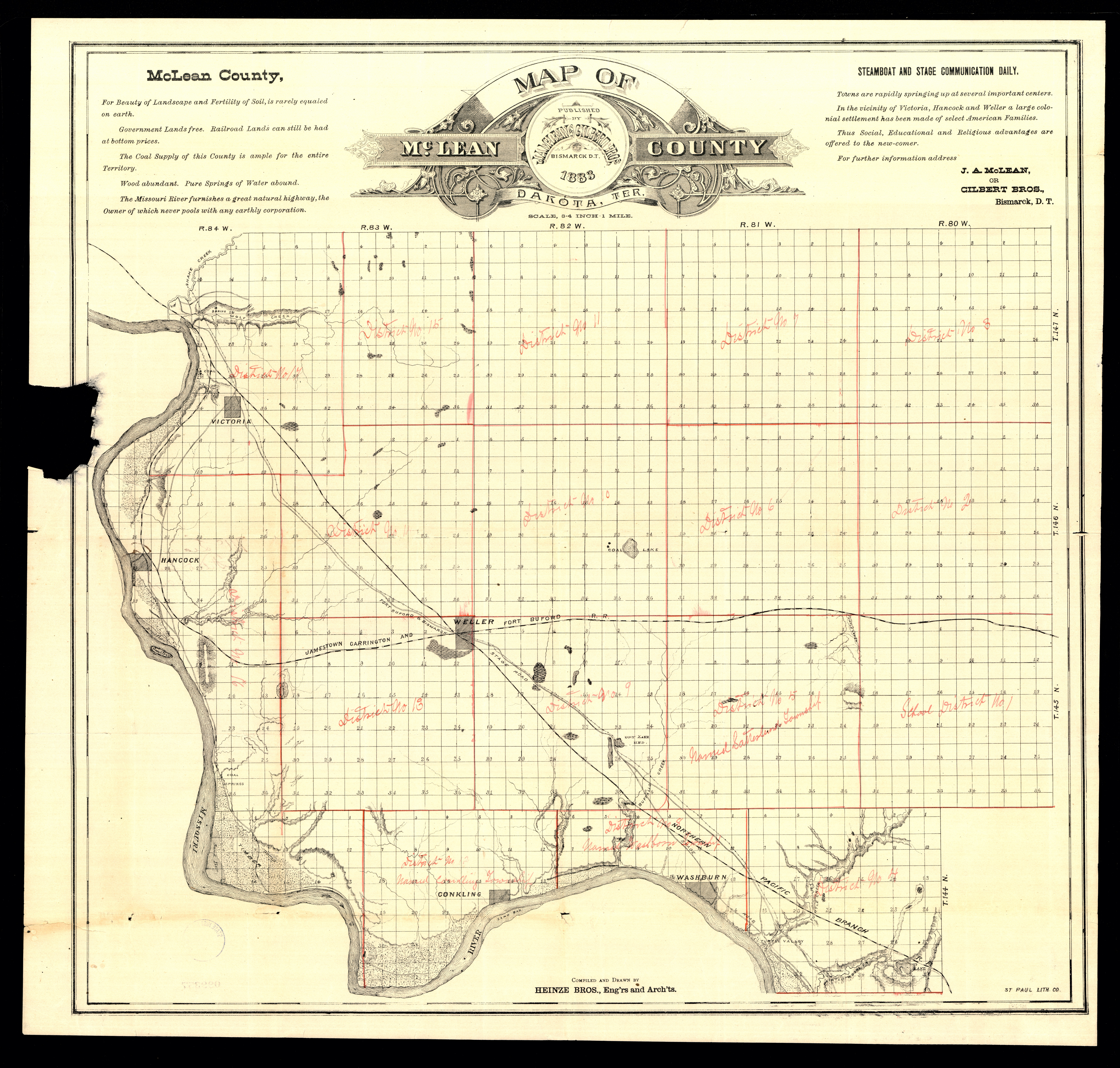
Collection: 978.475 H472m 1883 - Map of McLean County, Dakota Ter. / __ __compiled and drawn by Heinze Bros., Eng'rs and Arch'ts
Folder:
Library
Item:
978.475 H472m 1883
Date:
1883
Creator:
Heinze Bros
Title:
Map of McLean County, Dakota Ter. / __ __compiled and drawn by Heinze Bros., Eng'rs and Arch'ts